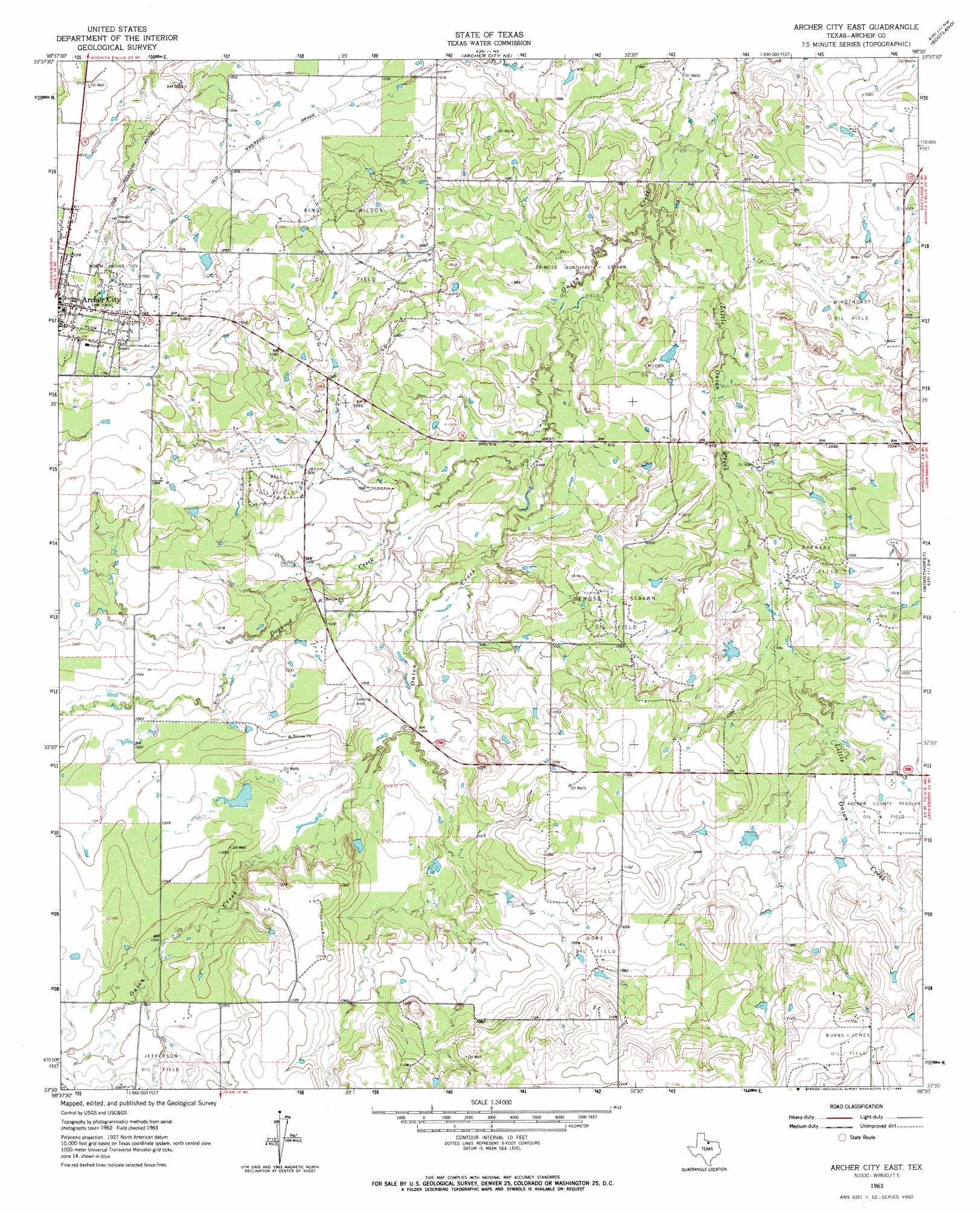
Archer City East Topo Map Texas
To zoom in, hover over the map of Archer City East
USGS Topo Quad 33098e5 - 1:24,000 scale
| Topo Map Name: | Archer City East |
| USGS Topo Quad ID: | 33098e5 |
| Print Size: | ca. 21 1/4" wide x 27" high |
| Southeast Coordinates: | 33.5° N latitude / 98.5° W longitude |
| Map Center Coordinates: | 33.5625° N latitude / 98.5625° W longitude |
| U.S. State: | TX |
| Filename: | o33098e5.jpg |
| Download Map JPG Image: | Archer City East topo map 1:24,000 scale |
| Map Type: | Topographic |
| Topo Series: | 7.5´ |
| Map Scale: | 1:24,000 |
| Source of Map Images: | United States Geological Survey (USGS) |
| Alternate Map Versions: |
Archer City East TX 1963, updated 1964 Download PDF Buy paper map Archer City East TX 2011 Download PDF Buy paper map Archer City East TX 2012 Download PDF Buy paper map Archer City East TX 2016 Download PDF Buy paper map |
1:24,000 Topo Quads surrounding Archer City East
Mankins |
Holliday |
Lake Wichita |
Sloop Creek |
Jolly |
Lake Kickapoo |
Dads Corner |
Archer City Ne |
Scotland |
Deer Creek |
Dundee Se |
Archer City West |
Archer City East |
Windthorst |
Scotland Se |
Lake Olney |
Bobcat Bluff |
Prickly Pear Branch |
Darnell Branch |
Antelope |
Olney |
True |
Loving |
Markley |
Lynn Creek |
> Back to 33098e1 at 1:100,000 scale
> Back to 33098a1 at 1:250,000 scale
> Back to U.S. Topo Maps home
Archer City East topo map: Gazetteer
Archer City East: Airports
Archer City Municipal Airport elevation 322m 1056′Archer City East: Dams
Schrieber Lake Dam elevation 313m 1026′Archer City East: Oilfields
Barbara Oil Field elevation 308m 1010′Bell Oil Field elevation 321m 1053′
Demoss Northeast- Strawn Oil Field elevation 290m 951′
Demoss- Strawn Oil Field elevation 318m 1043′
Gore Oil Field elevation 321m 1053′
Jefferson Oil Field elevation 324m 1062′
King-Wilson Oil Field elevation 318m 1043′
Moody Oil Field elevation 299m 980′
North Archer City Oil Field elevation 312m 1023′
Windthorst Oil Field elevation 301m 987′
Archer City East: Reservoirs
Schrieber Lake elevation 313m 1026′Archer City East: Streams
Dogwood Creek elevation 293m 961′Little Onion Creek elevation 290m 951′
Archer City East digital topo map on disk
Buy this Archer City East topo map showing relief, roads, GPS coordinates and other geographical features, as a high-resolution digital map file on DVD: