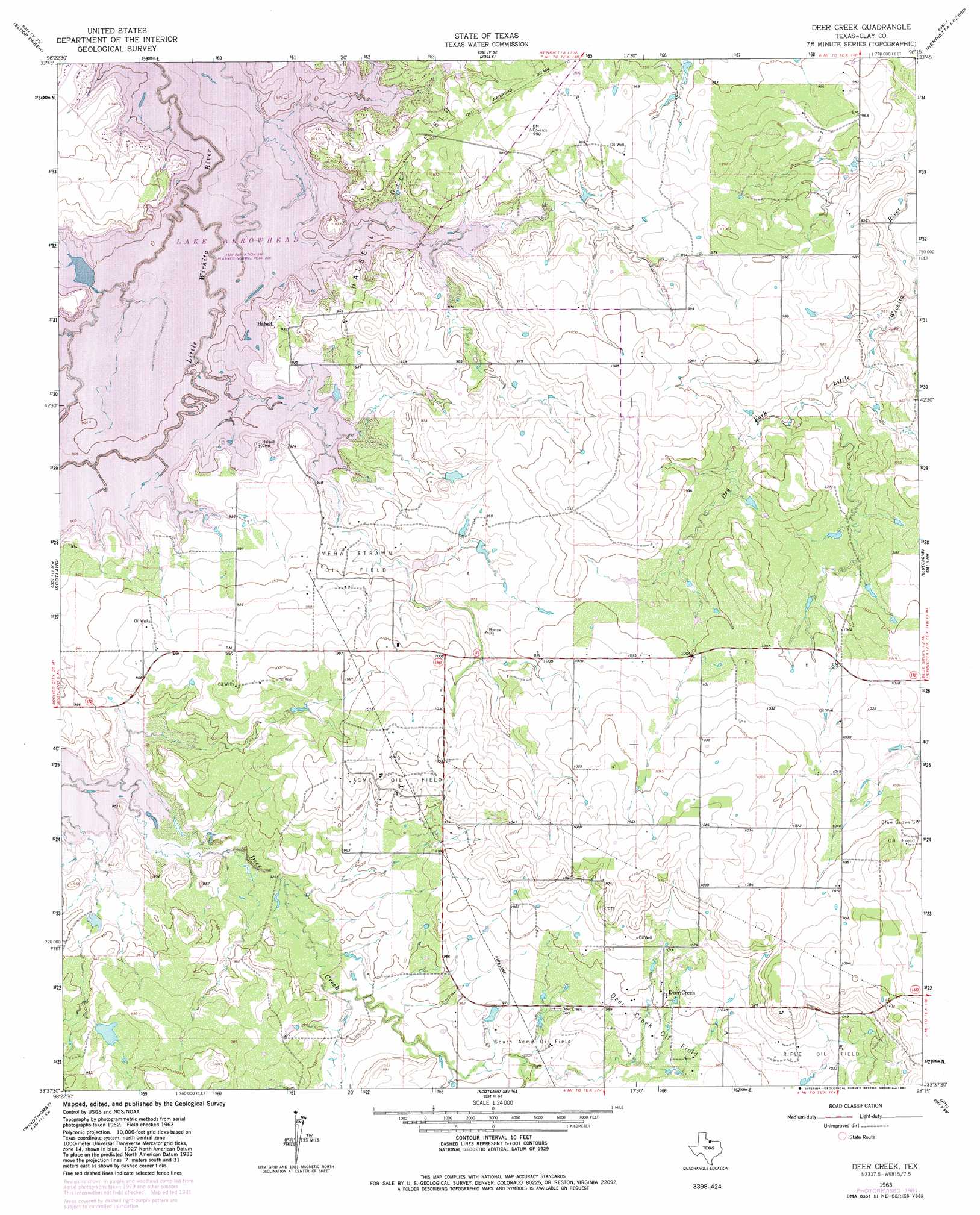
Deer Creek Topo Map Texas
To zoom in, hover over the map of Deer Creek
USGS Topo Quad 33098f3 - 1:24,000 scale
| Topo Map Name: | Deer Creek |
| USGS Topo Quad ID: | 33098f3 |
| Print Size: | ca. 21 1/4" wide x 27" high |
| Southeast Coordinates: | 33.625° N latitude / 98.25° W longitude |
| Map Center Coordinates: | 33.6875° N latitude / 98.3125° W longitude |
| U.S. State: | TX |
| Filename: | o33098f3.jpg |
| Download Map JPG Image: | Deer Creek topo map 1:24,000 scale |
| Map Type: | Topographic |
| Topo Series: | 7.5´ |
| Map Scale: | 1:24,000 |
| Source of Map Images: | United States Geological Survey (USGS) |
| Alternate Map Versions: |
Deer Creek TX 1963, updated 1964 Download PDF Buy paper map Deer Creek TX 1963, updated 1982 Download PDF Buy paper map Deer Creek TX 2010 Download PDF Buy paper map Deer Creek TX 2012 Download PDF Buy paper map Deer Creek TX 2016 Download PDF Buy paper map |
1:24,000 Topo Quads surrounding Deer Creek
Wichita Falls West |
Wichita Falls East |
Dean |
Hurnville |
Riverland Cemetery |
Lake Wichita |
Sloop Creek |
Jolly |
Henrietta |
Dickworsham |
Archer City Ne |
Scotland |
Deer Creek |
Bluegrove |
Bellevue |
Archer City East |
Windthorst |
Scotland Se |
Joy |
Vashti |
Prickly Pear Branch |
Darnell Branch |
Antelope |
Postoak |
Newport |
> Back to 33098e1 at 1:100,000 scale
> Back to 33098a1 at 1:250,000 scale
> Back to U.S. Topo Maps home
Deer Creek topo map: Gazetteer
Deer Creek: Dams
Berend Lake Dam elevation 294m 964′Halsell Estate Lake Dam elevation 287m 941′
Stephens Lake Dam elevation 285m 935′
W I Howard Lake Dam elevation 285m 935′
Deer Creek: Oilfields
Acme Oil Field elevation 318m 1043′Blue Grove Southwest Oil Field elevation 322m 1056′
Deer Creek Oil Field elevation 300m 984′
Halsell Oil Field elevation 279m 915′
Rifle Oil Field elevation 311m 1020′
South Acme Oil Field elevation 292m 958′
Vera Strawn Oil Field elevation 287m 941′
Deer Creek: Parks
Nocatee Park elevation 287m 941′Tonkawa Park elevation 306m 1003′
West Arrowhead Park elevation 287m 941′
Deer Creek: Populated Places
Deer Creek elevation 308m 1010′Halsell elevation 282m 925′
Deer Creek: Reservoirs
Berend Lake elevation 294m 964′Halsell Estate Lake elevation 287m 941′
Stephens Lake elevation 285m 935′
W I Howard Lake elevation 285m 935′
Deer Creek digital topo map on disk
Buy this Deer Creek topo map showing relief, roads, GPS coordinates and other geographical features, as a high-resolution digital map file on DVD: