Wichita Falls West Topo Map Texas
To zoom in, hover over the map of Wichita Falls West
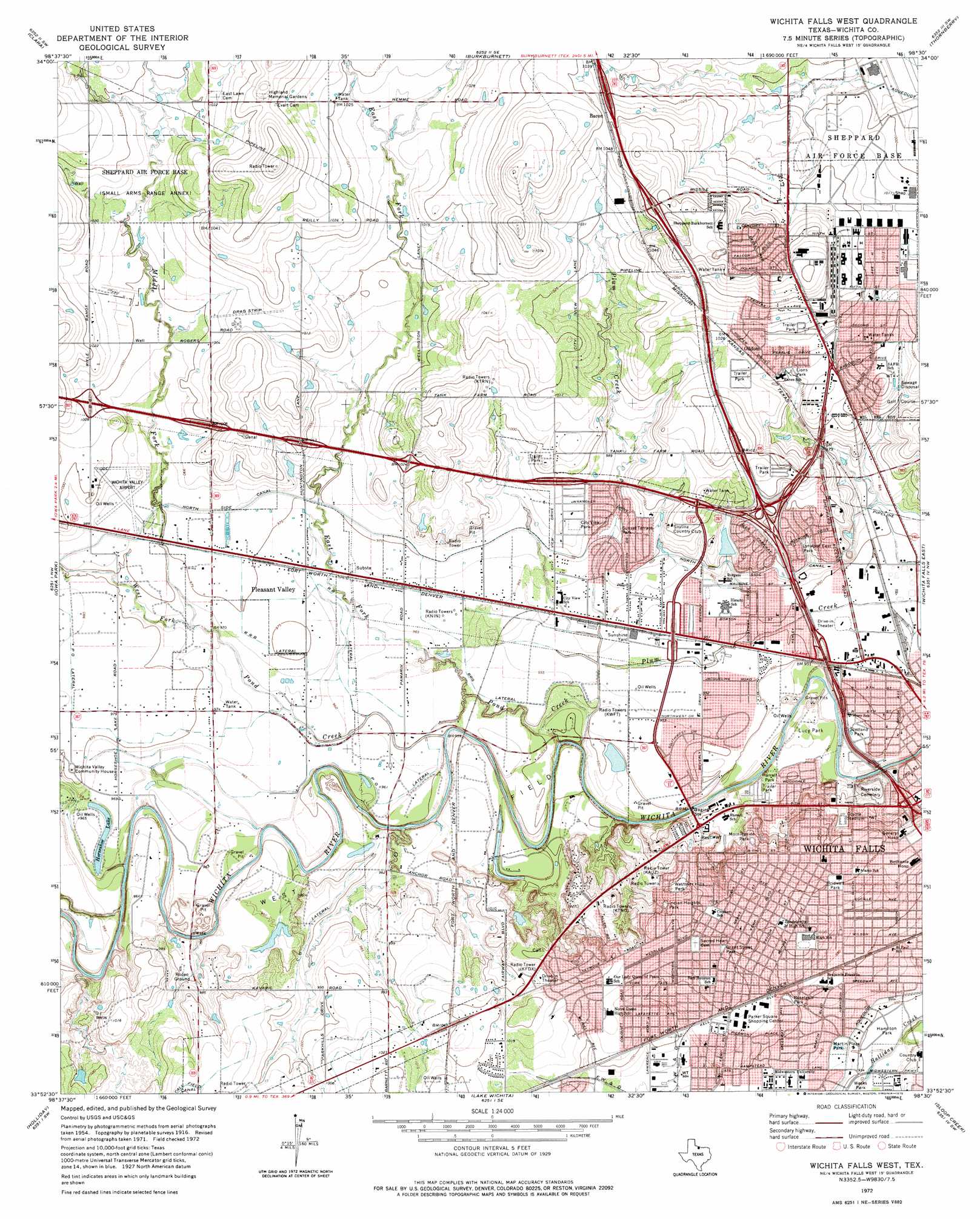
USGS Topo Quad 33098h5 - 1:24,000 scale
| Topo Map Name: | Wichita Falls West |
| USGS Topo Quad ID: | 33098h5 |
| Print Size: | ca. 21 1/4" wide x 27" high |
| Southeast Coordinates: | 33.875° N latitude / 98.5° W longitude |
| Map Center Coordinates: | 33.9375° N latitude / 98.5625° W longitude |
| U.S. State: | TX |
| Filename: | o33098h5.jpg |
| Download Map JPG Image: | Wichita Falls West topo map 1:24,000 scale |
| Map Type: | Topographic |
| Topo Series: | 7.5´ |
| Map Scale: | 1:24,000 |
| Source of Map Images: | United States Geological Survey (USGS) |
| Alternate Map Versions: |
Wichita Falls West TX 1957, updated 1958 Download PDF Buy paper map Wichita Falls West TX 1972, updated 1975 Download PDF Buy paper map Wichita Falls West TX 2010 Download PDF Buy paper map Wichita Falls West TX 2013 Download PDF Buy paper map Wichita Falls West TX 2016 Download PDF Buy paper map |
1:24,000 Topo Quads surrounding Wichita Falls West
Augar Creek |
Grandfield |
Devol |
Randlett |
Taylor |
Sunshine Hill |
Clara |
Burkburnett |
Thornberry |
Charlie |
Fowlkes |
Iowa Park |
Wichita Falls West |
Wichita Falls East |
Dean |
Mankins |
Holliday |
Lake Wichita |
Sloop Creek |
Jolly |
Lake Kickapoo |
Dads Corner |
Archer City Ne |
Scotland |
Deer Creek |
> Back to 33098e1 at 1:100,000 scale
> Back to 33098a1 at 1:250,000 scale
> Back to U.S. Topo Maps home
Wichita Falls West topo map: Gazetteer
Wichita Falls West: Airports
Wichita Valley Airport elevation 300m 984′Wichita Falls West: Canals
C G Lateral elevation 299m 980′North Side Canal elevation 296m 971′
P O Lateral elevation 297m 974′
R R B Lateral elevation 297m 974′
R R G Lateral elevation 292m 958′
R R Lateral elevation 294m 964′
Wichita Falls West: Dams
City of Wichita Falls Lake Dam elevation 302m 990′Wichita Falls West: Oilfields
West Oil Field elevation 293m 961′Wichita Falls West: Parks
Birdwell Park elevation 305m 1000′Bridwell Park elevation 306m 1003′
City View Park elevation 301m 987′
Coyote Stadium elevation 296m 971′
Grant Street Park elevation 306m 1003′
Hamilton Park elevation 289m 948′
Harrell Park elevation 287m 941′
Indian Heights Park elevation 312m 1023′
Lions Park elevation 306m 1003′
Lucy Park elevation 288m 944′
Lynwood East Park elevation 296m 971′
Martin Plaza Park elevation 291m 954′
Morningside Park elevation 303m 994′
Notre Dame Catholic School Baseball Field elevation 310m 1017′
Notre Dame Catholic School Football Field elevation 310m 1017′
Roselawn Park elevation 297m 974′
Scotland Ball Field elevation 288m 944′
Scotland Park elevation 289m 948′
Sunset Terrace Park elevation 296m 971′
Tesco Park elevation 299m 980′
Westover Hills Park elevation 313m 1026′
Wichita Falls High SchoolTrack elevation 305m 1000′
Wichita Falls West: Populated Places
Bacon elevation 319m 1046′Pleasant Valley elevation 296m 971′
Wichita Falls West: Reservoirs
City of Wichita Falls Lake elevation 302m 990′Horseshoe Lake elevation 292m 958′
Wichita Falls West: Streams
East Fork Pond Creek elevation 291m 954′Middle Fork Pond Creek elevation 294m 964′
Pond Creek elevation 285m 935′
West Fork Pond Creek elevation 291m 954′
Wichita Falls West: Trails
Lucy Park Trail elevation 289m 948′Riverbend Nature Works Trail elevation 286m 938′
Wichita Falls West digital topo map on disk
Buy this Wichita Falls West topo map showing relief, roads, GPS coordinates and other geographical features, as a high-resolution digital map file on DVD: