Lake Stamford West Topo Map Texas
To zoom in, hover over the map of Lake Stamford West
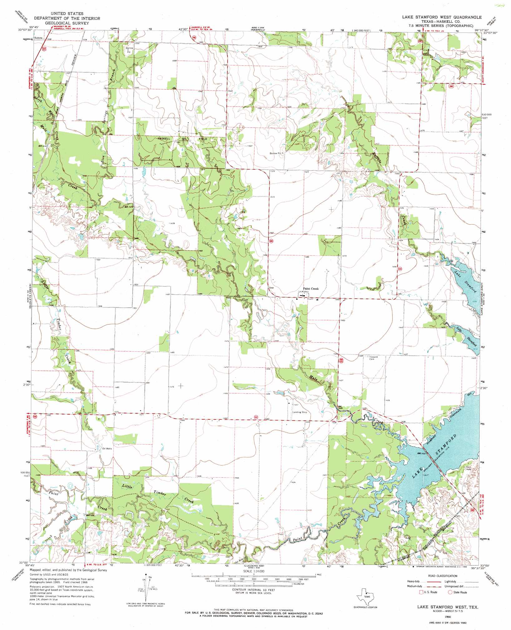
USGS Topo Quad 33099a6 - 1:24,000 scale
| Topo Map Name: | Lake Stamford West |
| USGS Topo Quad ID: | 33099a6 |
| Print Size: | ca. 21 1/4" wide x 27" high |
| Southeast Coordinates: | 33° N latitude / 99.625° W longitude |
| Map Center Coordinates: | 33.0625° N latitude / 99.6875° W longitude |
| U.S. State: | TX |
| Filename: | o33099a6.jpg |
| Download Map JPG Image: | Lake Stamford West topo map 1:24,000 scale |
| Map Type: | Topographic |
| Topo Series: | 7.5´ |
| Map Scale: | 1:24,000 |
| Source of Map Images: | United States Geological Survey (USGS) |
| Alternate Map Versions: |
Lake Stamford West TX 1966, updated 1969 Download PDF Buy paper map Lake Stamford West TX 2010 Download PDF Buy paper map Lake Stamford West TX 2013 Download PDF Buy paper map Lake Stamford West TX 2016 Download PDF Buy paper map |
1:24,000 Topo Quads surrounding Lake Stamford West
Jud |
Rochester |
Weinert |
Mattson |
Antelope Creek Sw |
Rule |
Pinkerton |
Haskell |
Irby |
Reynolds Bend Nw |
Sagerton |
Dudleys Creek |
Lake Stamford West |
Lake Stamford East |
Hoover Mountain |
Tuxedo |
Stamford |
Lueders Nw |
Lueders Ne |
Antelope Hills |
Anson |
Funston |
Lueders West |
Lueders East |
Collins Creek Sw |
> Back to 33099a1 at 1:100,000 scale
> Back to 33098a1 at 1:250,000 scale
> Back to U.S. Topo Maps home
Lake Stamford West topo map: Gazetteer
Lake Stamford West: Oilfields
Haskell Oil Field elevation 467m 1532′Lake Stamford West: Populated Places
Paint Creek elevation 450m 1476′Lake Stamford West: Streams
Buffalo Creek elevation 432m 1417′Flat Paint Creek elevation 433m 1420′
Little Timber Creek elevation 434m 1423′
Mule Creek elevation 432m 1417′
North Mule Creek elevation 454m 1489′
Rice Springs Branch elevation 451m 1479′
Stink Creek elevation 439m 1440′
Lake Stamford West digital topo map on disk
Buy this Lake Stamford West topo map showing relief, roads, GPS coordinates and other geographical features, as a high-resolution digital map file on DVD: