Northwest Lake Kemp Topo Map Texas
To zoom in, hover over the map of Northwest Lake Kemp
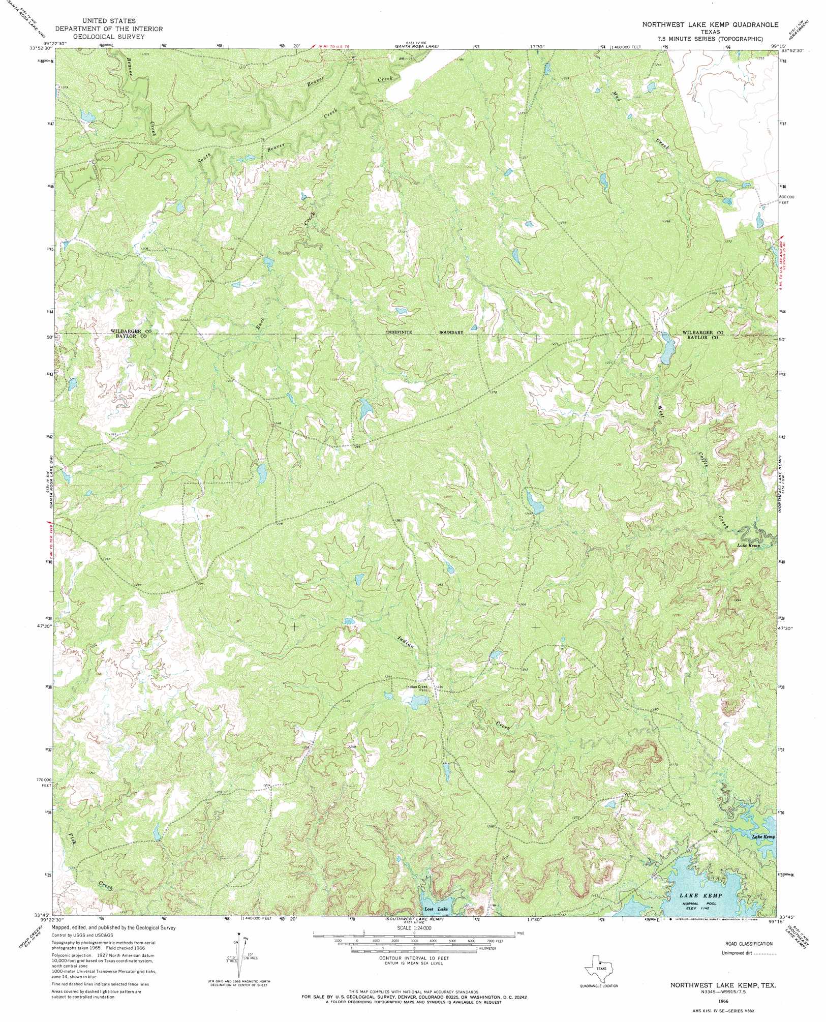
USGS Topo Quad 33099g3 - 1:24,000 scale
| Topo Map Name: | Northwest Lake Kemp |
| USGS Topo Quad ID: | 33099g3 |
| Print Size: | ca. 21 1/4" wide x 27" high |
| Southeast Coordinates: | 33.75° N latitude / 99.25° W longitude |
| Map Center Coordinates: | 33.8125° N latitude / 99.3125° W longitude |
| U.S. State: | TX |
| Filename: | o33099g3.jpg |
| Download Map JPG Image: | Northwest Lake Kemp topo map 1:24,000 scale |
| Map Type: | Topographic |
| Topo Series: | 7.5´ |
| Map Scale: | 1:24,000 |
| Source of Map Images: | United States Geological Survey (USGS) |
| Alternate Map Versions: |
Northwest Lake Kemp TX 1966, updated 1969 Download PDF Buy paper map Northwest Lake Kemp TX 2010 Download PDF Buy paper map Northwest Lake Kemp TX 2013 Download PDF Buy paper map Northwest Lake Kemp TX 2016 Download PDF Buy paper map |
1:24,000 Topo Quads surrounding Northwest Lake Kemp
Warrior Hollow |
Rayland |
Lockett |
Boggy Creek |
Harrold |
Thalia |
Santa Rosa Lake Nw |
Santa Rosa Lake |
Grayback |
Lake Electra |
Colwell Creek |
Santa Rosa Lake Sw |
Northwest Lake Kemp |
Northeast Lake Kemp |
Franklin Bend |
Vera |
Soap Creek |
Southwest Lake Kemp |
Southeast Lake Kemp |
Fulda |
Hefner |
Bomarton |
Seymour West |
Seymour East |
Cope Branch |
> Back to 33099e1 at 1:100,000 scale
> Back to 33098a1 at 1:250,000 scale
> Back to U.S. Topo Maps home
Northwest Lake Kemp topo map: Gazetteer
Northwest Lake Kemp: Dams
Waggoner Lake Number 1 Dam elevation 372m 1220′Waggoner Lake Number 2 Dam elevation 377m 1236′
Waggoner Lake Number 3 Dam elevation 374m 1227′
Waggoner Lake Number 4 Dam elevation 378m 1240′
Northwest Lake Kemp: Reservoirs
Waggoner Lake Number 1 elevation 372m 1220′Waggoner Lake Number 2 elevation 377m 1236′
Waggoner Lake Number 3 elevation 374m 1227′
Waggoner Lake Number 4 elevation 378m 1240′
Northwest Lake Kemp: Streams
Buck Creek elevation 360m 1181′Indian Creek elevation 350m 1148′
South Beaver Creek elevation 357m 1171′
Northwest Lake Kemp digital topo map on disk
Buy this Northwest Lake Kemp topo map showing relief, roads, GPS coordinates and other geographical features, as a high-resolution digital map file on DVD: