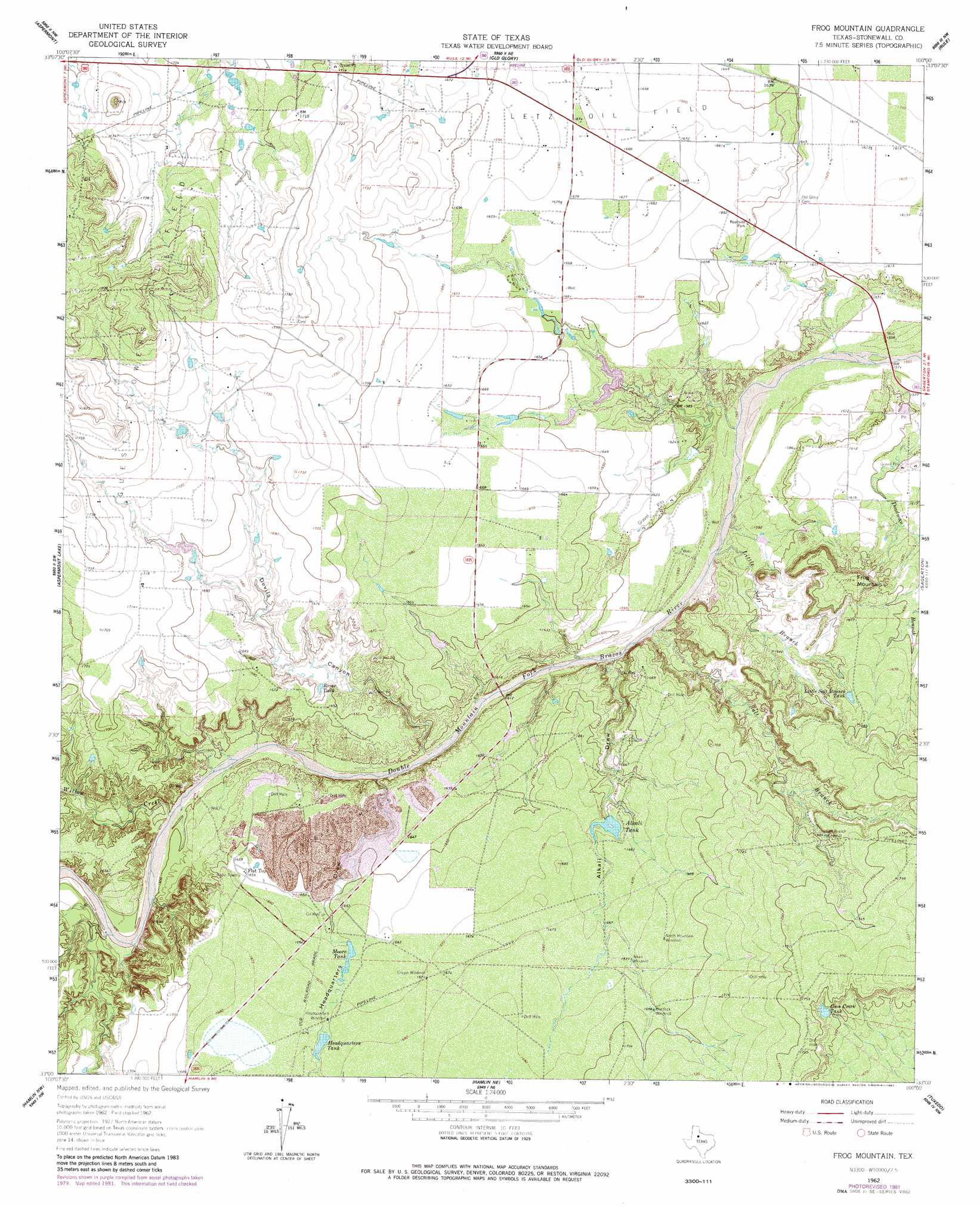
Frog Mountain Topo Map Texas
To zoom in, hover over the map of Frog Mountain
USGS Topo Quad 33100a1 - 1:24,000 scale
| Topo Map Name: | Frog Mountain |
| USGS Topo Quad ID: | 33100a1 |
| Print Size: | ca. 21 1/4" wide x 27" high |
| Southeast Coordinates: | 33° N latitude / 100° W longitude |
| Map Center Coordinates: | 33.0625° N latitude / 100.0625° W longitude |
| U.S. State: | TX |
| Filename: | o33100a1.jpg |
| Download Map JPG Image: | Frog Mountain topo map 1:24,000 scale |
| Map Type: | Topographic |
| Topo Series: | 7.5´ |
| Map Scale: | 1:24,000 |
| Source of Map Images: | United States Geological Survey (USGS) |
| Alternate Map Versions: |
Frog Mountain TX 1962, updated 1966 Download PDF Buy paper map Frog Mountain TX 1962, updated 1981 Download PDF Buy paper map Frog Mountain TX 2010 Download PDF Buy paper map Frog Mountain TX 2012 Download PDF Buy paper map Frog Mountain TX 2016 Download PDF Buy paper map |
1:24,000 Topo Quads surrounding Frog Mountain
Lovers Resort |
Kiowa Peak Sw |
Kiowa Peak |
Jud |
Rochester |
Swenson |
Aspermont |
Old Glory |
Rule |
Pinkerton |
Coon Hollow |
Aspermont Lake |
Frog Mountain |
Sagerton |
Dudleys Creek |
Poke Mountain |
Hamlin Nw |
Hamlin Ne |
Tuxedo |
Stamford |
Royston |
Mccaulley |
Neinda |
Anson |
Funston |
> Back to 33100a1 at 1:100,000 scale
> Back to 33100a1 at 1:250,000 scale
> Back to U.S. Topo Maps home
Frog Mountain topo map: Gazetteer
Frog Mountain: Oilfields
Letz Oil Field elevation 509m 1669′Frog Mountain: Populated Places
Flat Top elevation 505m 1656′Frog Mountain: Reservoirs
Alkali Tank elevation 503m 1650′Coon Creek Tank elevation 525m 1722′
Headquarters Tank elevation 509m 1669′
Little Salt Branch Tank elevation 508m 1666′
Moore Tank elevation 506m 1660′
River Tank elevation 497m 1630′
Frog Mountain: Streams
Little Salt Branch elevation 478m 1568′Salt Branch elevation 478m 1568′
Willow Creek elevation 484m 1587′
Frog Mountain: Summits
Frog Mountain elevation 526m 1725′Frog Mountain: Valleys
Alkali Draw elevation 481m 1578′Devils Canyon elevation 488m 1601′
Headquarters Draw elevation 484m 1587′
Frog Mountain digital topo map on disk
Buy this Frog Mountain topo map showing relief, roads, GPS coordinates and other geographical features, as a high-resolution digital map file on DVD: