Foreman Chapel Topo Map Texas
To zoom in, hover over the map of Foreman Chapel
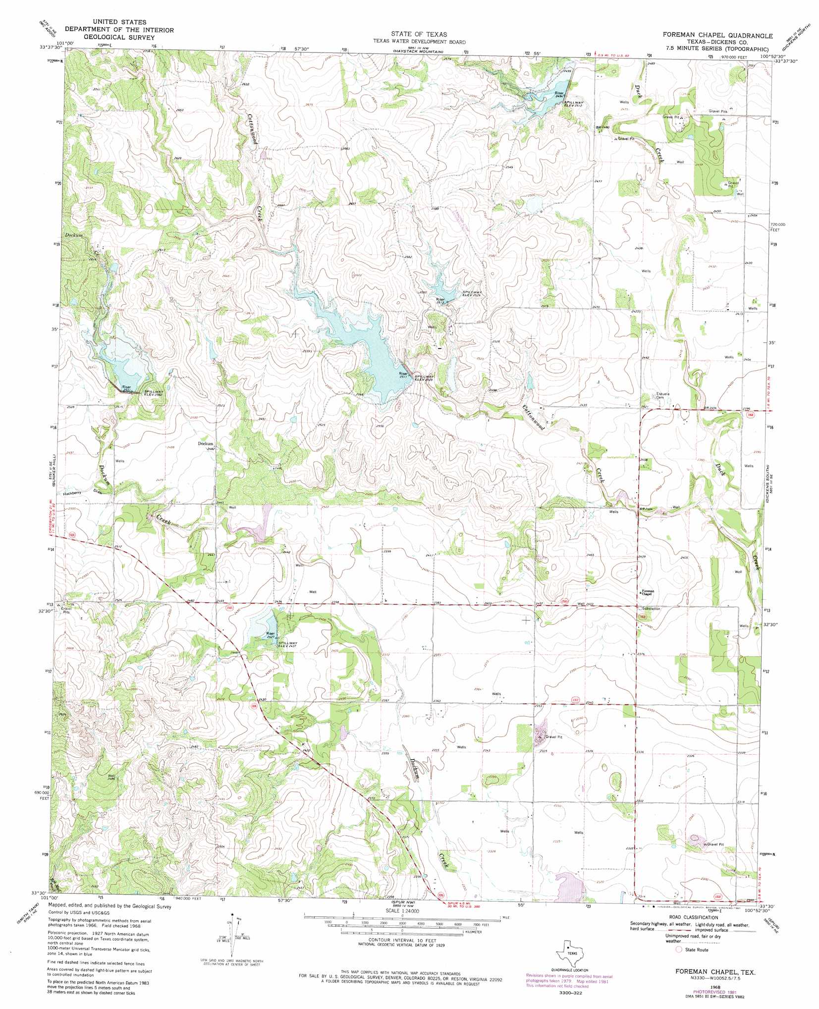
USGS Topo Quad 33100e8 - 1:24,000 scale
| Topo Map Name: | Foreman Chapel |
| USGS Topo Quad ID: | 33100e8 |
| Print Size: | ca. 21 1/4" wide x 27" high |
| Southeast Coordinates: | 33.5° N latitude / 100.875° W longitude |
| Map Center Coordinates: | 33.5625° N latitude / 100.9375° W longitude |
| U.S. State: | TX |
| Filename: | o33100e8.jpg |
| Download Map JPG Image: | Foreman Chapel topo map 1:24,000 scale |
| Map Type: | Topographic |
| Topo Series: | 7.5´ |
| Map Scale: | 1:24,000 |
| Source of Map Images: | United States Geological Survey (USGS) |
| Alternate Map Versions: |
Foreman Chapel TX 1968, updated 1970 Download PDF Buy paper map Foreman Chapel TX 1968, updated 1981 Download PDF Buy paper map Foreman Chapel TX 2010 Download PDF Buy paper map Foreman Chapel TX 2012 Download PDF Buy paper map Foreman Chapel TX 2016 Download PDF Buy paper map |
1:24,000 Topo Quads surrounding Foreman Chapel
Mount Blanco |
Wake |
Rustler Camp |
Afton |
Sanders Hollow |
Crosbyton |
Mcadoo |
Haystack Mountain |
Dickens North |
East Afton |
Collett Springs |
Bunker Hill |
Foreman Chapel |
Dickens South |
Croton Camp |
Kalgary |
Smith Tank |
Spur Nw |
Spur |
Gilpin |
Verbena |
Twomile Creek |
Spur Sw |
White Camp |
Girard |
> Back to 33100e1 at 1:100,000 scale
> Back to 33100a1 at 1:250,000 scale
> Back to U.S. Topo Maps home
Foreman Chapel topo map: Gazetteer
Foreman Chapel: Dams
Hale Lake Dam elevation 704m 2309′Soil Conservation Service Site 10 Dam elevation 724m 2375′
Soil Conservation Service Site 3 Dam elevation 758m 2486′
Soil Conservation Service Site 4 Dam elevation 771m 2529′
Soil Conservation Service Site 5 Dam elevation 757m 2483′
Soil Conservation Service Site 7 Dam elevation 772m 2532′
Soil Conservation Service Site 8 Dam elevation 738m 2421′
Soil Conservation Service Site 9 Dam elevation 738m 2421′
Spur Headquarters Ranch Dam elevation 778m 2552′
Foreman Chapel: Reservoirs
Hale Lake elevation 704m 2309′Soil Conservation Service Site 10 Reservoir elevation 724m 2375′
Soil Conservation Service Site 3 Reservoir elevation 758m 2486′
Soil Conservation Service Site 4 Reservoir elevation 771m 2529′
Soil Conservation Service Site 5 Reservoir elevation 757m 2483′
Soil Conservation Service Site 7 Reservoir elevation 772m 2532′
Soil Conservation Service Site 8 Reservoir elevation 738m 2421′
Soil Conservation Service Site 9 Reservoir elevation 738m 2421′
Spur Headquarters Ranch Lake elevation 778m 2552′
Foreman Chapel: Streams
Cottonwood Creek elevation 719m 2358′Foreman Chapel: Valleys
Hackberry Draw elevation 753m 2470′Foreman Chapel digital topo map on disk
Buy this Foreman Chapel topo map showing relief, roads, GPS coordinates and other geographical features, as a high-resolution digital map file on DVD: