Justiceburg Se Topo Map Texas
To zoom in, hover over the map of Justiceburg Se
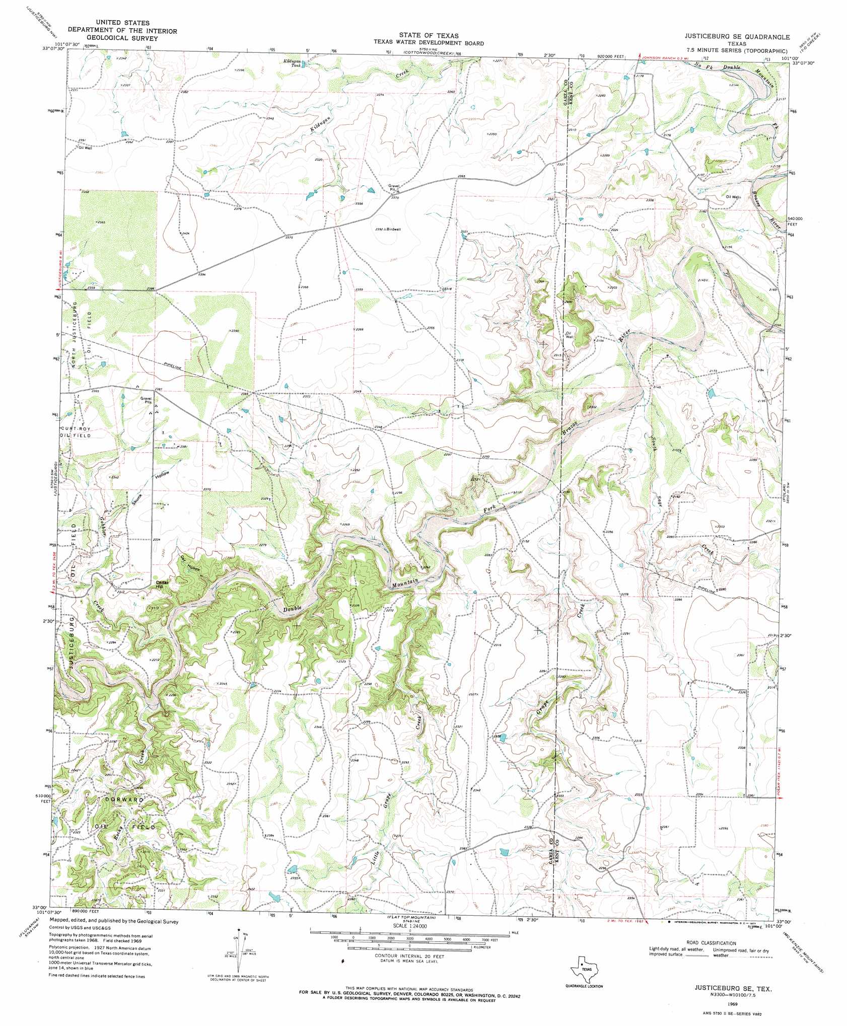
USGS Topo Quad 33101a1 - 1:24,000 scale
| Topo Map Name: | Justiceburg Se |
| USGS Topo Quad ID: | 33101a1 |
| Print Size: | ca. 21 1/4" wide x 27" high |
| Southeast Coordinates: | 33° N latitude / 101° W longitude |
| Map Center Coordinates: | 33.0625° N latitude / 101.0625° W longitude |
| U.S. State: | TX |
| Filename: | o33101a1.jpg |
| Download Map JPG Image: | Justiceburg Se topo map 1:24,000 scale |
| Map Type: | Topographic |
| Topo Series: | 7.5´ |
| Map Scale: | 1:24,000 |
| Source of Map Images: | United States Geological Survey (USGS) |
| Alternate Map Versions: |
Justiceburg SE TX 1969, updated 1971 Download PDF Buy paper map Justiceburg SE TX 2010 Download PDF Buy paper map Justiceburg SE TX 2012 Download PDF Buy paper map Justiceburg SE TX 2016 Download PDF Buy paper map |
1:24,000 Topo Quads surrounding Justiceburg Se
Cap Rock Se |
Verbena |
Twomile Creek |
Spur Sw |
White Camp |
Post East |
Justiceburg Nw |
Cottonwood Creek |
T-O Creek |
Clairemont West |
Cooper Creek |
Justiceburg |
Justiceburg Se |
Polar |
Cooper Mountain |
Gail Ne |
Fluvanna |
Flat Top Mountain |
Mckenzie Mountains |
Maverick Creek |
Fivemile Creek |
Arah |
Dermott |
Brand |
Lloyd Mountain |
> Back to 33101a1 at 1:100,000 scale
> Back to 33100a1 at 1:250,000 scale
> Back to U.S. Topo Maps home
Justiceburg Se topo map: Gazetteer
Justiceburg Se: Lakes
Lake Alan Henry elevation 658m 2158′Justiceburg Se: Oilfields
Dorward Oil Field elevation 704m 2309′Justiceburg Se: Reservoirs
Kildugan Tank elevation 702m 2303′Justiceburg Se: Streams
Grape Creek elevation 646m 2119′Little Grape Creek elevation 658m 2158′
North Fork Double Mountain Fork Brazos River elevation 639m 2096′
Rocky Creek elevation 665m 2181′
South Sage Creek elevation 644m 2112′
Justiceburg Se: Summits
Cedar Hill elevation 715m 2345′Justiceburg Se: Valleys
Cat Hollow elevation 661m 2168′Skunk Hollow elevation 695m 2280′
Justiceburg Se digital topo map on disk
Buy this Justiceburg Se topo map showing relief, roads, GPS coordinates and other geographical features, as a high-resolution digital map file on DVD: