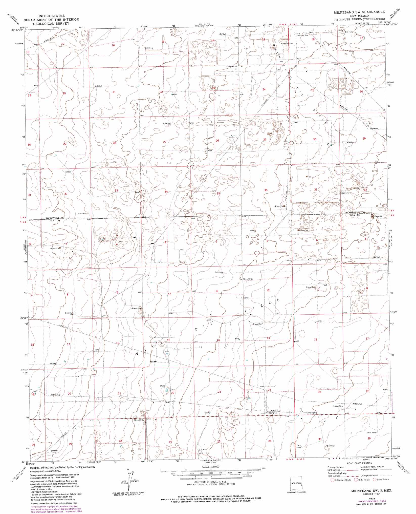
Milnesand Sw Topo Map New Mexico
To zoom in, hover over the map of Milnesand Sw
USGS Topo Quad 33103e4 - 1:24,000 scale
| Topo Map Name: | Milnesand Sw |
| USGS Topo Quad ID: | 33103e4 |
| Print Size: | ca. 21 1/4" wide x 27" high |
| Southeast Coordinates: | 33.5° N latitude / 103.375° W longitude |
| Map Center Coordinates: | 33.5625° N latitude / 103.4375° W longitude |
| U.S. State: | NM |
| Filename: | o33103e4.jpg |
| Download Map JPG Image: | Milnesand Sw topo map 1:24,000 scale |
| Map Type: | Topographic |
| Topo Series: | 7.5´ |
| Map Scale: | 1:24,000 |
| Source of Map Images: | United States Geological Survey (USGS) |
| Alternate Map Versions: |
Milnesand SW NM 1972, updated 1975 Download PDF Buy paper map Milnesand SW NM 1972, updated 1985 Download PDF Buy paper map Milnesand SW NM 2010 Download PDF Buy paper map Milnesand SW NM 2013 Download PDF Buy paper map Milnesand SW NM 2017 Download PDF Buy paper map |
1:24,000 Topo Quads surrounding Milnesand Sw
Schram Lake |
Elida Se |
Dora Sw |
Pep |
Garrison |
Button Mesa North |
Button Mesa Ne |
Milnesand Nw |
Milnesand |
Bluit |
Button Mesa South |
Flying M Ranch |
Milnesand Sw |
Crossroads |
Bledsoe Sw |
Caprock |
Lane Salt Lake |
Johnson Ranch |
Ranger Lake |
Walking Cane Ranch |
Soldier Hill |
Dallas Store |
Simanola Valley |
Tatum North |
Gladiola |
> Back to 33103e1 at 1:100,000 scale
> Back to 33102a1 at 1:250,000 scale
> Back to U.S. Topo Maps home
Milnesand Sw topo map: Gazetteer
Milnesand Sw: Oilfields
Milnesand Oil Field elevation 1287m 4222′Vada Oil Field elevation 1288m 4225′
Milnesand Sw: Wells
06226 Water Well elevation 1289m 4229′12530 Water Well elevation 1294m 4245′
12531 Water Well elevation 1294m 4245′
12532 Water Well elevation 1293m 4242′
12533 Water Well elevation 1293m 4242′
12534 Water Well elevation 1292m 4238′
12535 Water Well elevation 1307m 4288′
12536 Water Well elevation 1307m 4288′
12538 Water Well elevation 1303m 4274′
12539 Water Well elevation 1302m 4271′
12541 Water Well elevation 1292m 4238′
12542 Water Well elevation 1303m 4274′
12543 Water Well elevation 1278m 4192′
12544 Water Well elevation 1272m 4173′
12578 Water Well elevation 1297m 4255′
12579 Water Well elevation 1300m 4265′
12584 Water Well elevation 1293m 4242′
12585 Water Well elevation 1288m 4225′
12586 Water Well elevation 1294m 4245′
12587 Water Well elevation 1301m 4268′
12595 Water Well elevation 1283m 4209′
12600 Water Well elevation 1284m 4212′
12601 Water Well elevation 1282m 4206′
13372 Water Well elevation 1289m 4229′
13373 Water Well elevation 1301m 4268′
13374 Water Well elevation 1298m 4258′
Milnesand Sw digital topo map on disk
Buy this Milnesand Sw topo map showing relief, roads, GPS coordinates and other geographical features, as a high-resolution digital map file on DVD: