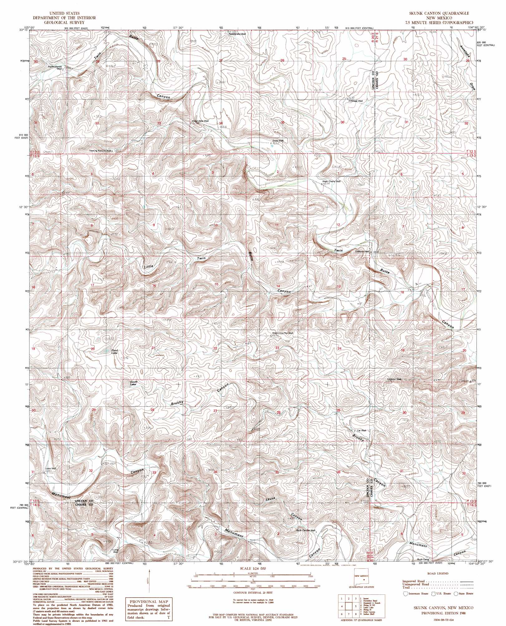
Skunk Canyon Topo Map New Mexico
To zoom in, hover over the map of Skunk Canyon
USGS Topo Quad 33104b8 - 1:24,000 scale
| Topo Map Name: | Skunk Canyon |
| USGS Topo Quad ID: | 33104b8 |
| Print Size: | ca. 21 1/4" wide x 27" high |
| Southeast Coordinates: | 33.125° N latitude / 104.875° W longitude |
| Map Center Coordinates: | 33.1875° N latitude / 104.9375° W longitude |
| U.S. State: | NM |
| Filename: | o33104b8.jpg |
| Download Map JPG Image: | Skunk Canyon topo map 1:24,000 scale |
| Map Type: | Topographic |
| Topo Series: | 7.5´ |
| Map Scale: | 1:24,000 |
| Source of Map Images: | United States Geological Survey (USGS) |
| Alternate Map Versions: |
Skunk Canyon NM 1988, updated 1989 Download PDF Buy paper map Skunk Canyon NM 2010 Download PDF Buy paper map Skunk Canyon NM 2013 Download PDF Buy paper map Skunk Canyon NM 2017 Download PDF Buy paper map |
1:24,000 Topo Quads surrounding Skunk Canyon
Nelson Canyon West |
Nelson Canyon East |
Horseshoe Bend Nw |
Blackwater Hill |
Corn Ranch |
Tinnie |
Sunset |
Horseshoe Bend |
Diamond A Ranch |
Hondo Reservoir |
Flying H Nw |
Flying H Ne |
Skunk Canyon |
Lucky Lake |
Juan Lake |
Loco Canyon |
Flying H |
Dark Canyon |
Indian Bluff |
Kincaid Ranch |
Thimble Canyon |
Singer Lake |
Sagebrush Valley W. |
Sagebrush Valley E. |
Hope Nw |
> Back to 33104a1 at 1:100,000 scale
> Back to 33104a1 at 1:250,000 scale
> Back to U.S. Topo Maps home
Skunk Canyon topo map: Gazetteer
Skunk Canyon: Lakes
Pond Lake elevation 1541m 5055′South Lake elevation 1527m 5009′
Skunk Canyon: Valleys
Brushy Canyon elevation 1336m 4383′Little Twin Butte Canyon elevation 1346m 4416′
Skunk Canyon elevation 1374m 4507′
Skunk Canyon: Wells
Antelope Well elevation 1429m 4688′Black Canyon Well elevation 1375m 4511′
Cat Well elevation 1375m 4511′
Dicks Well elevation 1413m 4635′
Little Well elevation 1445m 4740′
Lone Well elevation 1484m 4868′
Lookout Well elevation 1447m 4747′
Lubbock Well elevation 1358m 4455′
Martin Harold Well elevation 1473m 4832′
Mattox Well elevation 1456m 4776′
Mothers Well elevation 1506m 4940′
Rattlesnake Well elevation 1439m 4721′
Water Hole Well elevation 1430m 4691′
West Cherry Well elevation 1386m 4547′
West Crow Flat Well elevation 1476m 4842′
Yearling Pasture Well elevation 1486m 4875′
Skunk Canyon digital topo map on disk
Buy this Skunk Canyon topo map showing relief, roads, GPS coordinates and other geographical features, as a high-resolution digital map file on DVD: