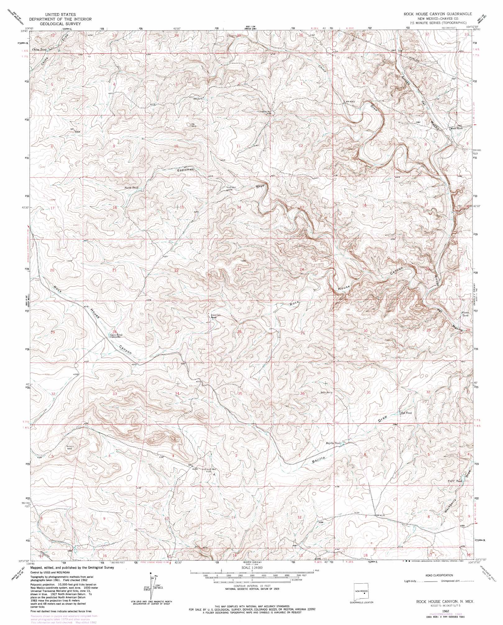
Rock House Canyon Topo Map New Mexico
To zoom in, hover over the map of Rock House Canyon
USGS Topo Quad 33104f6 - 1:24,000 scale
| Topo Map Name: | Rock House Canyon |
| USGS Topo Quad ID: | 33104f6 |
| Print Size: | ca. 21 1/4" wide x 27" high |
| Southeast Coordinates: | 33.625° N latitude / 104.625° W longitude |
| Map Center Coordinates: | 33.6875° N latitude / 104.6875° W longitude |
| U.S. State: | NM |
| Filename: | o33104f6.jpg |
| Download Map JPG Image: | Rock House Canyon topo map 1:24,000 scale |
| Map Type: | Topographic |
| Topo Series: | 7.5´ |
| Map Scale: | 1:24,000 |
| Source of Map Images: | United States Geological Survey (USGS) |
| Alternate Map Versions: |
Rock House Canyon NM 1962, updated 1964 Download PDF Buy paper map Rock House Canyon NM 1962, updated 1982 Download PDF Buy paper map Rock House Canyon NM 2010 Download PDF Buy paper map Rock House Canyon NM 2013 Download PDF Buy paper map Rock House Canyon NM 2017 Download PDF Buy paper map |
1:24,000 Topo Quads surrounding Rock House Canyon
Chivita Canyon |
Round Mountain |
Mesa |
Dunlap Sill |
Swallow Nest Canyon |
North Lake |
Round Mountain Se |
Mesa Sw |
Mesa Se |
Shannon Draw |
White Flat |
Deep Well |
Rock House Canyon |
Marley Draw |
Coyote Draw |
Elsie Canyon |
White Flat Se |
Barn Draw |
Panther Hill |
Melena |
Horseshoe Bend Nw |
Blackwater Hill |
Corn Ranch |
Roswell North |
Bitter Lake |
> Back to 33104e1 at 1:100,000 scale
> Back to 33104a1 at 1:250,000 scale
> Back to U.S. Topo Maps home
Rock House Canyon topo map: Gazetteer
Rock House Canyon: Reservoirs
Bajillo Tank elevation 1220m 4002′CCC Tank elevation 1218m 3996′
China Tank elevation 1312m 4304′
Flores Tank elevation 1175m 3854′
Gavi Tank elevation 1306m 4284′
North Tank elevation 1318m 4324′
Red Tank elevation 1205m 3953′
Rock House Canyon: Valleys
China Draw elevation 1183m 3881′Eddleman Draw elevation 1197m 3927′
Rock House Canyon elevation 1171m 3841′
Rock House Canyon: Wells
10000 Water Well elevation 1208m 3963′10452 Water Well elevation 1235m 4051′
10750 Water Well elevation 1199m 3933′
10769 Water Well elevation 1257m 4124′
Bajillo Well elevation 1257m 4124′
Rock House Canyon digital topo map on disk
Buy this Rock House Canyon topo map showing relief, roads, GPS coordinates and other geographical features, as a high-resolution digital map file on DVD: