Deep Well Topo Map New Mexico
To zoom in, hover over the map of Deep Well
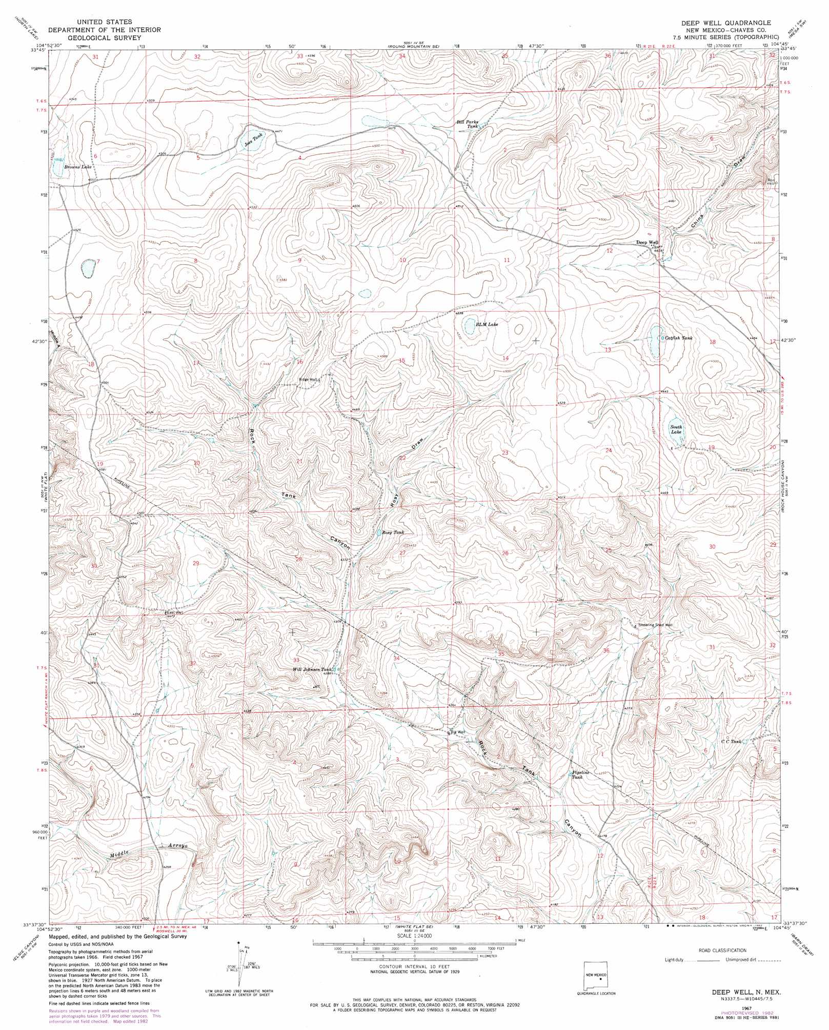
USGS Topo Quad 33104f7 - 1:24,000 scale
| Topo Map Name: | Deep Well |
| USGS Topo Quad ID: | 33104f7 |
| Print Size: | ca. 21 1/4" wide x 27" high |
| Southeast Coordinates: | 33.625° N latitude / 104.75° W longitude |
| Map Center Coordinates: | 33.6875° N latitude / 104.8125° W longitude |
| U.S. State: | NM |
| Filename: | o33104f7.jpg |
| Download Map JPG Image: | Deep Well topo map 1:24,000 scale |
| Map Type: | Topographic |
| Topo Series: | 7.5´ |
| Map Scale: | 1:24,000 |
| Source of Map Images: | United States Geological Survey (USGS) |
| Alternate Map Versions: |
Deep Well NM 1967, updated 1971 Download PDF Buy paper map Deep Well NM 1967, updated 1982 Download PDF Buy paper map Deep Well NM 2010 Download PDF Buy paper map Deep Well NM 2013 Download PDF Buy paper map Deep Well NM 2017 Download PDF Buy paper map |
1:24,000 Topo Quads surrounding Deep Well
Juan Largo Canyon East |
Chivita Canyon |
Round Mountain |
Mesa |
Dunlap Sill |
Cistern Draw |
North Lake |
Round Mountain Se |
Mesa Sw |
Mesa Se |
Arroyo Serrano East |
White Flat |
Deep Well |
Rock House Canyon |
Marley Draw |
Granville Canyon |
Elsie Canyon |
White Flat Se |
Barn Draw |
Panther Hill |
Nelson Canyon East |
Horseshoe Bend Nw |
Blackwater Hill |
Corn Ranch |
Roswell North |
> Back to 33104e1 at 1:100,000 scale
> Back to 33104a1 at 1:250,000 scale
> Back to U.S. Topo Maps home
Deep Well topo map: Gazetteer
Deep Well: Lakes
Blm Lake elevation 1377m 4517′Browns Lake elevation 1377m 4517′
South Lake elevation 1349m 4425′
Deep Well: Reservoirs
Bill Parks Tank elevation 1355m 4445′Catfish Tank elevation 1351m 4432′
CC Tank elevation 1299m 4261′
Joes Tank elevation 1362m 4468′
Pipeline Tank elevation 1282m 4206′
Rosy Tank elevation 1326m 4350′
Will Johnson Tank elevation 1307m 4288′
Deep Well: Valleys
Rosy Draw elevation 1324m 4343′Deep Well: Wells
Big Well elevation 1293m 4242′East Well elevation 1364m 4475′
Ridge Well elevation 1379m 4524′
Shearing Shed Well elevation 1316m 4317′
Deep Well digital topo map on disk
Buy this Deep Well topo map showing relief, roads, GPS coordinates and other geographical features, as a high-resolution digital map file on DVD: