Haystack Butte Topo Map New Mexico
To zoom in, hover over the map of Haystack Butte
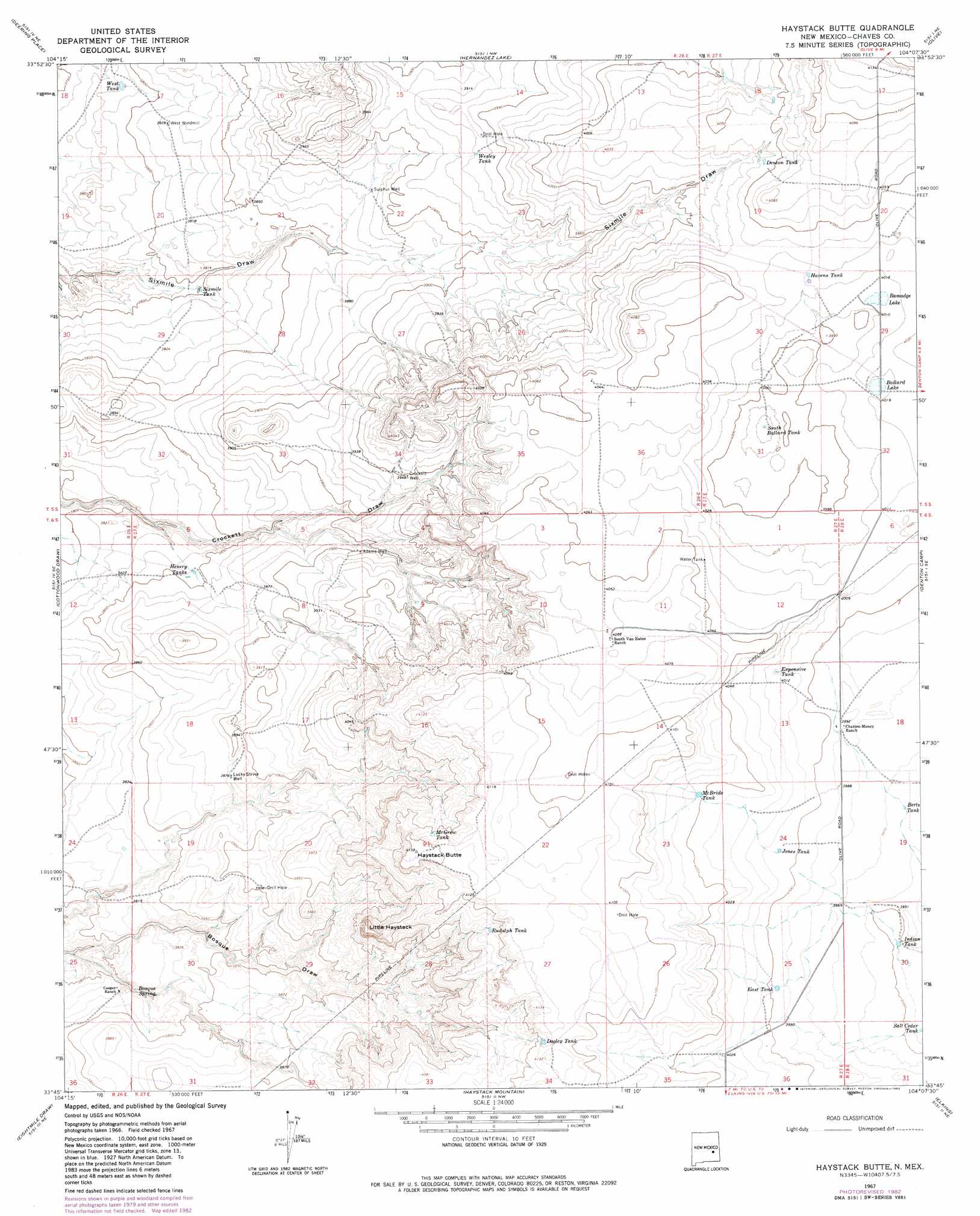
USGS Topo Quad 33104g2 - 1:24,000 scale
| Topo Map Name: | Haystack Butte |
| USGS Topo Quad ID: | 33104g2 |
| Print Size: | ca. 21 1/4" wide x 27" high |
| Southeast Coordinates: | 33.75° N latitude / 104.125° W longitude |
| Map Center Coordinates: | 33.8125° N latitude / 104.1875° W longitude |
| U.S. State: | NM |
| Filename: | o33104g2.jpg |
| Download Map JPG Image: | Haystack Butte topo map 1:24,000 scale |
| Map Type: | Topographic |
| Topo Series: | 7.5´ |
| Map Scale: | 1:24,000 |
| Source of Map Images: | United States Geological Survey (USGS) |
| Alternate Map Versions: |
Haystack Butte NM 1967, updated 1971 Download PDF Buy paper map Haystack Butte NM 1967, updated 1982 Download PDF Buy paper map Haystack Butte NM 2010 Download PDF Buy paper map Haystack Butte NM 2013 Download PDF Buy paper map Haystack Butte NM 2017 Download PDF Buy paper map |
1:24,000 Topo Quads surrounding Haystack Butte
Lovelady Draw |
La Espia Peak |
Cooley Lake |
Howell Ranch |
Rippee Ranch |
Swallow Nest Canyon |
Deering Place |
Hernandez Lake |
Olive |
San Juan Mesa West |
Shannon Draw |
Cottonwood Draw |
Haystack Butte |
Denton Camp |
Kenna Sw |
Coyote Draw |
Eightmile Draw |
Haystack Mountain |
Elkins |
Curlew Lake |
Melena |
Acme |
Campbell |
Sardine Lake |
Presler Lake |
> Back to 33104e1 at 1:100,000 scale
> Back to 33104a1 at 1:250,000 scale
> Back to U.S. Topo Maps home
Haystack Butte topo map: Gazetteer
Haystack Butte: Lakes
Ballard Lake elevation 1225m 4019′Ramadge Lake elevation 1225m 4019′
Haystack Butte: Reservoirs
Berts Tank elevation 1209m 3966′Denton Tank elevation 1233m 4045′
Dooley Tank elevation 1253m 4110′
East Tank elevation 1218m 3996′
Expensive Tank elevation 1223m 4012′
Havens Tank elevation 1228m 4028′
Henery Tanks elevation 1173m 3848′
Indian Tank elevation 1203m 3946′
Jones Tank elevation 1221m 4005′
McBride Tank elevation 1236m 4055′
McGrew Tank elevation 1255m 4117′
Rudolph Tank elevation 1246m 4087′
Salt Cedar Tank elevation 1200m 3937′
Sixmile Tank elevation 1159m 3802′
South Ballard Tank elevation 1213m 3979′
Wesley Tank elevation 1199m 3933′
West Tank elevation 1153m 3782′
Haystack Butte: Springs
Bosque Spring elevation 1160m 3805′Haystack Butte: Summits
Haystack Butte elevation 1267m 4156′Little Haystack elevation 1255m 4117′
Haystack Butte: Wells
06300 Water Well elevation 1204m 3950′06301 Water Well elevation 1239m 4064′
06302 Water Well elevation 1220m 4002′
06303 Water Well elevation 1239m 4064′
Adams Well elevation 1190m 3904′
Crockett Well elevation 1204m 3950′
Sulphur Well elevation 1181m 3874′
West Windmill elevation 1166m 3825′
Haystack Butte digital topo map on disk
Buy this Haystack Butte topo map showing relief, roads, GPS coordinates and other geographical features, as a high-resolution digital map file on DVD: