Swallow Nest Canyon Topo Map New Mexico
To zoom in, hover over the map of Swallow Nest Canyon
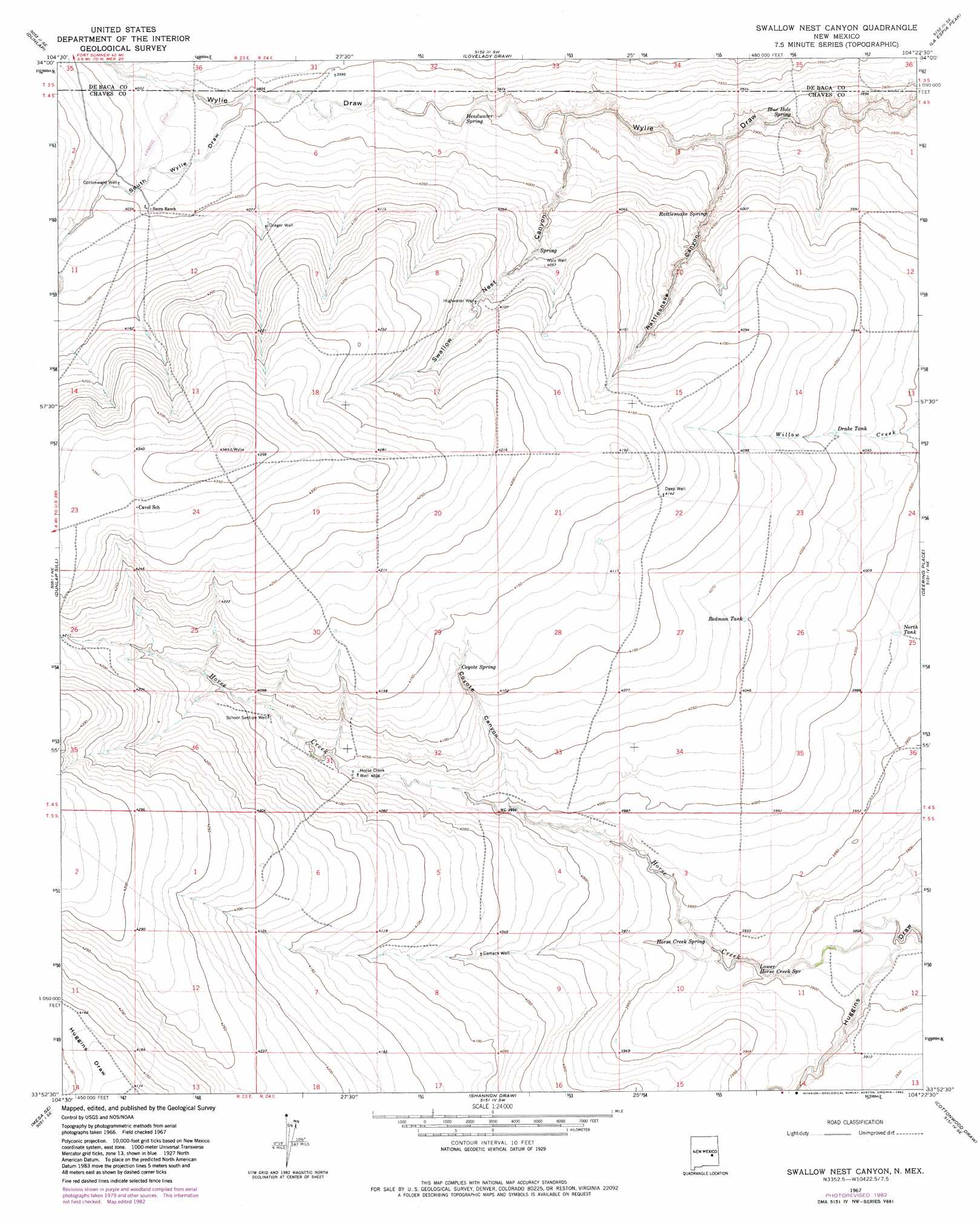
USGS Topo Quad 33104h4 - 1:24,000 scale
| Topo Map Name: | Swallow Nest Canyon |
| USGS Topo Quad ID: | 33104h4 |
| Print Size: | ca. 21 1/4" wide x 27" high |
| Southeast Coordinates: | 33.875° N latitude / 104.375° W longitude |
| Map Center Coordinates: | 33.9375° N latitude / 104.4375° W longitude |
| U.S. State: | NM |
| Filename: | o33104h4.jpg |
| Download Map JPG Image: | Swallow Nest Canyon topo map 1:24,000 scale |
| Map Type: | Topographic |
| Topo Series: | 7.5´ |
| Map Scale: | 1:24,000 |
| Source of Map Images: | United States Geological Survey (USGS) |
| Alternate Map Versions: |
Swallow Nest Canyon NM 1967, updated 1971 Download PDF Buy paper map Swallow Nest Canyon NM 1967, updated 1982 Download PDF Buy paper map Swallow Nest Canyon NM 2010 Download PDF Buy paper map Swallow Nest Canyon NM 2013 Download PDF Buy paper map Swallow Nest Canyon NM 2017 Download PDF Buy paper map |
1:24,000 Topo Quads surrounding Swallow Nest Canyon
The Old Dry Lake |
Dunlap Ne |
Conejo Creek West |
Conejo Creek East |
Eighteenmile Hill |
Devils Well |
Dunlap |
Lovelady Draw |
La Espia Peak |
Cooley Lake |
Mesa |
Dunlap Sill |
Swallow Nest Canyon |
Deering Place |
Hernandez Lake |
Mesa Sw |
Mesa Se |
Shannon Draw |
Cottonwood Draw |
Haystack Butte |
Rock House Canyon |
Marley Draw |
Coyote Draw |
Eightmile Draw |
Haystack Mountain |
> Back to 33104e1 at 1:100,000 scale
> Back to 33104a1 at 1:250,000 scale
> Back to U.S. Topo Maps home
Swallow Nest Canyon topo map: Gazetteer
Swallow Nest Canyon: Reservoirs
Drake Tank elevation 1230m 4035′North Tank elevation 1214m 3982′
Redman Tank elevation 1235m 4051′
Swallow Nest Canyon: Springs
Blue Hole Spring elevation 1179m 3868′Coyote Spring elevation 1258m 4127′
Headwater Spring elevation 1205m 3953′
Horse Creek Spring elevation 1191m 3907′
Lower Horse Creek Spring elevation 1189m 3900′
Rattlesnake Spring elevation 1206m 3956′
Swallow Nest Canyon: Streams
Horse Creek elevation 1174m 3851′Swallow Nest Canyon: Valleys
Coyote Canyon elevation 1218m 3996′Rattlesnake Canyon elevation 1184m 3884′
South Wylie Draw elevation 1217m 3992′
Swallow Nest Canyon elevation 1195m 3920′
Swallow Nest Canyon: Wells
10382 Water Well elevation 1216m 3989′10723 Water Well elevation 1236m 4055′
10727 Water Well elevation 1257m 4124′
10728 Water Well elevation 1249m 4097′
10729 Water Well elevation 1261m 4137′
10730 Water Well elevation 1255m 4117′
10731 Water Well elevation 1235m 4051′
Camack Well elevation 1229m 4032′
Cottonwood Well elevation 1233m 4045′
Deep Well elevation 1262m 4140′
Drager Well elevation 1248m 4094′
Highwater Well elevation 1249m 4097′
Horse Creek Well elevation 1231m 4038′
School Section Well elevation 1245m 4084′
Wyly Well elevation 1238m 4061′
Swallow Nest Canyon digital topo map on disk
Buy this Swallow Nest Canyon topo map showing relief, roads, GPS coordinates and other geographical features, as a high-resolution digital map file on DVD: