Dunlap Sill Topo Map New Mexico
To zoom in, hover over the map of Dunlap Sill
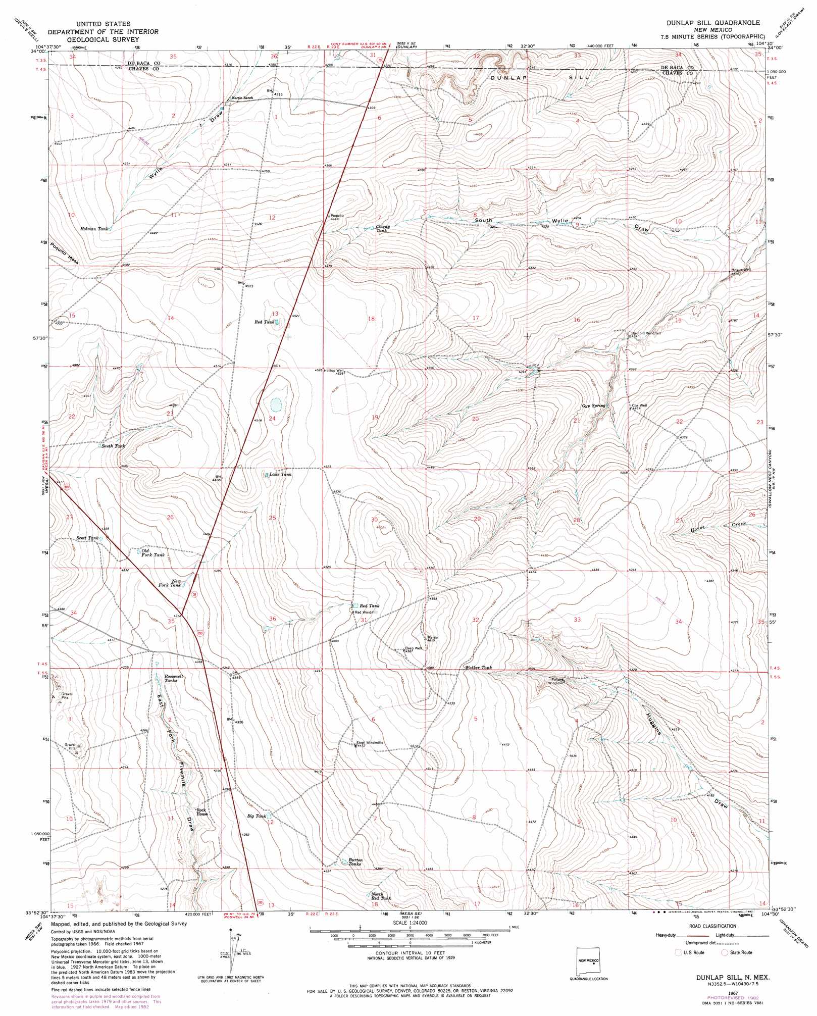
USGS Topo Quad 33104h5 - 1:24,000 scale
| Topo Map Name: | Dunlap Sill |
| USGS Topo Quad ID: | 33104h5 |
| Print Size: | ca. 21 1/4" wide x 27" high |
| Southeast Coordinates: | 33.875° N latitude / 104.5° W longitude |
| Map Center Coordinates: | 33.9375° N latitude / 104.5625° W longitude |
| U.S. State: | NM |
| Filename: | o33104h5.jpg |
| Download Map JPG Image: | Dunlap Sill topo map 1:24,000 scale |
| Map Type: | Topographic |
| Topo Series: | 7.5´ |
| Map Scale: | 1:24,000 |
| Source of Map Images: | United States Geological Survey (USGS) |
| Alternate Map Versions: |
Dunlap Sill NM 1967, updated 1971 Download PDF Buy paper map Dunlap Sill NM 1967, updated 1982 Download PDF Buy paper map Dunlap Sill NM 2010 Download PDF Buy paper map Dunlap Sill NM 2013 Download PDF Buy paper map Dunlap Sill NM 2017 Download PDF Buy paper map |
1:24,000 Topo Quads surrounding Dunlap Sill
Wright Ranch |
The Old Dry Lake |
Dunlap Ne |
Conejo Creek West |
Conejo Creek East |
Wire Lake |
Devils Well |
Dunlap |
Lovelady Draw |
La Espia Peak |
Round Mountain |
Mesa |
Dunlap Sill |
Swallow Nest Canyon |
Deering Place |
Round Mountain Se |
Mesa Sw |
Mesa Se |
Shannon Draw |
Cottonwood Draw |
Deep Well |
Rock House Canyon |
Marley Draw |
Coyote Draw |
Eightmile Draw |
> Back to 33104e1 at 1:100,000 scale
> Back to 33104a1 at 1:250,000 scale
> Back to U.S. Topo Maps home
Dunlap Sill topo map: Gazetteer
Dunlap Sill: Cliffs
Dunlap Sill elevation 1314m 4311′Dunlap Sill: Reservoirs
Big Tank elevation 1313m 4307′Burton Tanks elevation 1327m 4353′
Clardy Tank elevation 1328m 4356′
Holman Tank elevation 1344m 4409′
Lake Tank elevation 1358m 4455′
New Fork Tank elevation 1323m 4340′
North Red Tank elevation 1319m 4327′
Old Fork Tank elevation 1319m 4327′
Red Tank elevation 1373m 4504′
Red Tank elevation 1375m 4511′
Roosevelt Tanks elevation 1302m 4271′
Scott Tank elevation 1329m 4360′
South Tank elevation 1330m 4363′
Walker Tank elevation 1373m 4504′
Dunlap Sill: Springs
Gyp Spring elevation 1288m 4225′Dunlap Sill: Summits
PoquitA Mesa elevation 1373m 4504′Dunlap Sill: Wells
Cox Well elevation 1303m 4274′Deep Well elevation 1398m 4586′
Hilltop Well elevation 1381m 4530′
Hogue Well elevation 1254m 4114′
Dunlap Sill digital topo map on disk
Buy this Dunlap Sill topo map showing relief, roads, GPS coordinates and other geographical features, as a high-resolution digital map file on DVD: