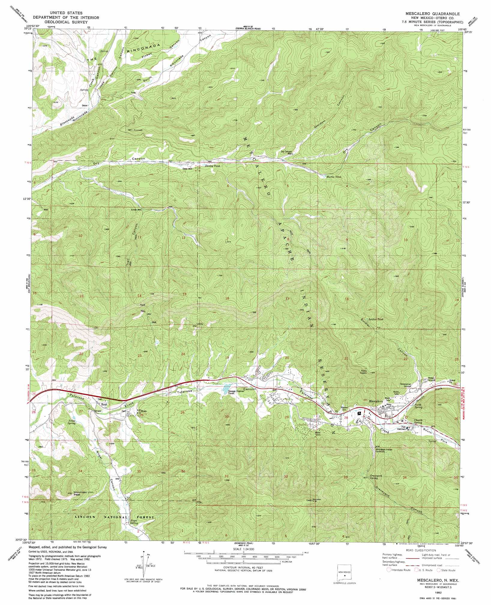
Mescalero Topo Map New Mexico
To zoom in, hover over the map of Mescalero
USGS Topo Quad 33105b7 - 1:24,000 scale
| Topo Map Name: | Mescalero |
| USGS Topo Quad ID: | 33105b7 |
| Print Size: | ca. 21 1/4" wide x 27" high |
| Southeast Coordinates: | 33.125° N latitude / 105.75° W longitude |
| Map Center Coordinates: | 33.1875° N latitude / 105.8125° W longitude |
| U.S. State: | NM |
| Filename: | o33105b7.jpg |
| Download Map JPG Image: | Mescalero topo map 1:24,000 scale |
| Map Type: | Topographic |
| Topo Series: | 7.5´ |
| Map Scale: | 1:24,000 |
| Source of Map Images: | United States Geological Survey (USGS) |
| Alternate Map Versions: |
Mescalero NM 1982, updated 1982 Download PDF Buy paper map Mescalero NM 2004, updated 2006 Download PDF Buy paper map Mescalero NM 2011 Download PDF Buy paper map Mescalero NM 2013 Download PDF Buy paper map |
| FStopo: | US Forest Service topo Mescalero is available: Download FStopo PDF Download FStopo TIF |
1:24,000 Topo Quads surrounding Mescalero
Oscura |
Godfrey Peak |
Nogal Peak |
Angus |
Fort Stanton |
Three Rivers |
Golondrina Draw |
Sierra Blanca Peak |
Ruidoso |
Ruidoso Downs |
Tularosa Ne |
Cat Mountain |
Mescalero |
Apache Summit |
Whitetail |
Tularosa |
Sabinata Flat |
Domingo Peak |
Firman Canyon |
Elk-Silver |
Malone Draw |
Alamogordo North |
High Rolls |
Cloudcroft |
Harvey Ranch |
> Back to 33105a1 at 1:100,000 scale
> Back to 33104a1 at 1:250,000 scale
> Back to U.S. Topo Maps home
Mescalero topo map: Gazetteer
Mescalero: Airports
Ihs Hospital Heliport elevation 2061m 6761′Mescalero: Mines
Mescalero Magnetite-Hematite elevation 2017m 6617′Mescalero: Parks
Saint Josephs Mission Historical Marker elevation 2003m 6571′Mescalero: Populated Places
Bent elevation 1775m 5823′Blazers Mill elevation 1965m 6446′
Mescalero elevation 2016m 6614′
Mescalero: Post Offices
Bent Post Office elevation 1775m 5823′Mescalero Post Office elevation 2016m 6614′
Mescalero: Ranges
Sacramento Mountains elevation 2204m 7230′Mescalero: Reservoirs
Danley Tank elevation 1959m 6427′Martin Tank elevation 2205m 7234′
Soldier Tank elevation 2195m 7201′
Mescalero: Springs
Church Spring elevation 2028m 6653′Graveyard Spring elevation 2094m 6870′
Nogal Spring elevation 1902m 6240′
North Spring elevation 2372m 7782′
Telles Spring elevation 1776m 5826′
Mescalero: Summits
Mountain Lion Peak elevation 2037m 6683′Mescalero: Valleys
Graveyard Canyon elevation 1992m 6535′Jose Carrillo Canyon elevation 1797m 5895′
Mardem Canyon elevation 2040m 6692′
Nogal Canyon elevation 1756m 5761′
North Fork Tularosa Canyon elevation 2008m 6587′
Pinkey Canyon elevation 1832m 6010′
Soldier Canyon elevation 2061m 6761′
South Fork Tularosa Canyon elevation 2008m 6587′
South Rinconada Canyon elevation 1815m 5954′
Trail Canyon elevation 1952m 6404′
Mescalero: Wells
10144 Water Well elevation 1892m 6207′Deep Well elevation 1956m 6417′
Dry Can Water Well elevation 2055m 6742′
Dry Canyon Well elevation 2081m 6827′
Smith Well elevation 1949m 6394′
Mescalero digital topo map on disk
Buy this Mescalero topo map showing relief, roads, GPS coordinates and other geographical features, as a high-resolution digital map file on DVD: