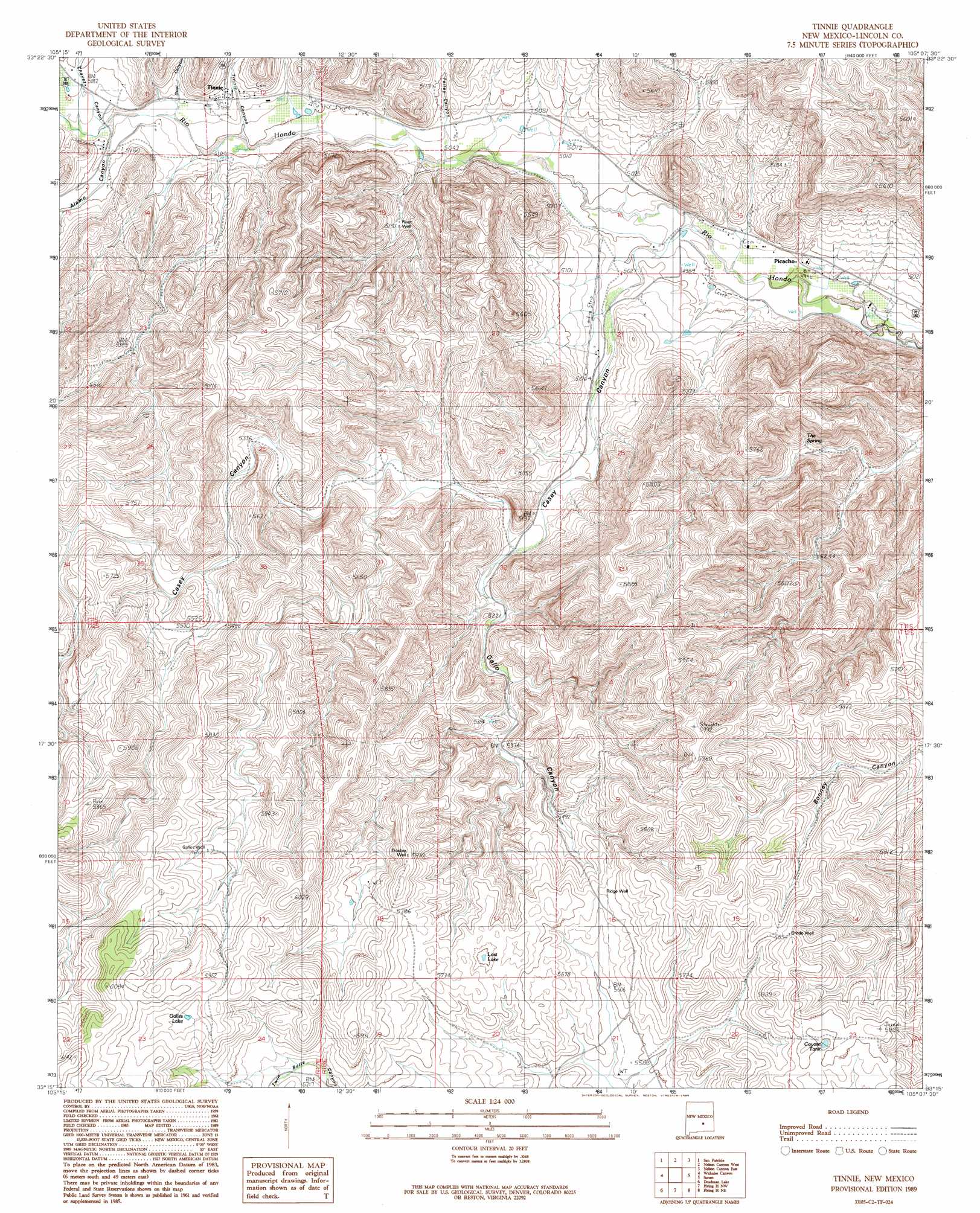
Tinnie Topo Map New Mexico
To zoom in, hover over the map of Tinnie
USGS Topo Quad 33105c2 - 1:24,000 scale
| Topo Map Name: | Tinnie |
| USGS Topo Quad ID: | 33105c2 |
| Print Size: | ca. 21 1/4" wide x 27" high |
| Southeast Coordinates: | 33.25° N latitude / 105.125° W longitude |
| Map Center Coordinates: | 33.3125° N latitude / 105.1875° W longitude |
| U.S. State: | NM |
| Filename: | o33105c2.jpg |
| Download Map JPG Image: | Tinnie topo map 1:24,000 scale |
| Map Type: | Topographic |
| Topo Series: | 7.5´ |
| Map Scale: | 1:24,000 |
| Source of Map Images: | United States Geological Survey (USGS) |
| Alternate Map Versions: |
Tinnie NM 1989, updated 1989 Download PDF Buy paper map Tinnie NM 2010 Download PDF Buy paper map Tinnie NM 2013 Download PDF Buy paper map |
1:24,000 Topo Quads surrounding Tinnie
Capitan Pass |
Capitan Peak |
Arabela |
Granville Canyon |
Elsie Canyon |
Lincoln |
San Patricio |
Nelson Canyon West |
Nelson Canyon East |
Horseshoe Bend Nw |
Sheeppen Canyon |
Wahalee Canyon |
Tinnie |
Sunset |
Horseshoe Bend |
Pajarita Mountain |
Deadman Lake |
Flying H Nw |
Flying H Ne |
Skunk Canyon |
Turkey Peak |
Clements Ranch |
Loco Canyon |
Flying H |
Dark Canyon |
> Back to 33105a1 at 1:100,000 scale
> Back to 33104a1 at 1:250,000 scale
> Back to U.S. Topo Maps home
Tinnie topo map: Gazetteer
Tinnie: Airports
Diamond A Ranch Airport elevation 1564m 5131′Tinnie: Bridges
Rio Hondo Bridge elevation 1576m 5170′Tinnie: Lakes
Galles Lake elevation 1802m 5912′Lost Lake elevation 1735m 5692′
Tinnie: Mines
Butts Pit elevation 1554m 5098′Tinnie: Populated Places
Picacho elevation 1520m 4986′Tinnie elevation 1576m 5170′
Tinnie: Post Offices
Picacho Post Office elevation 1520m 4986′Tinnie Post Office (historical) elevation 1576m 5170′
Tinnie: Reservoirs
Coyote Tank elevation 1769m 5803′Tinnie: Springs
The Spring elevation 1609m 5278′Tinnie: Streams
Baca Spring Creek elevation 1572m 5157′Tinnie: Valleys
Alamo Canyon elevation 1565m 5134′Casey Canyon elevation 1527m 5009′
Chavez Canyon elevation 1572m 5157′
Gallo Canyon elevation 1570m 5150′
Goat Canyon elevation 1561m 5121′
Tinnie Canyon elevation 1561m 5121′
Tinnie: Wells
Divide Well elevation 1785m 5856′Galles Well elevation 1773m 5816′
Ridge Well elevation 1732m 5682′
River Well elevation 1573m 5160′
Trouble Well elevation 1778m 5833′
Tinnie digital topo map on disk
Buy this Tinnie topo map showing relief, roads, GPS coordinates and other geographical features, as a high-resolution digital map file on DVD: