Sierra Blanca Peak Topo Map New Mexico
To zoom in, hover over the map of Sierra Blanca Peak
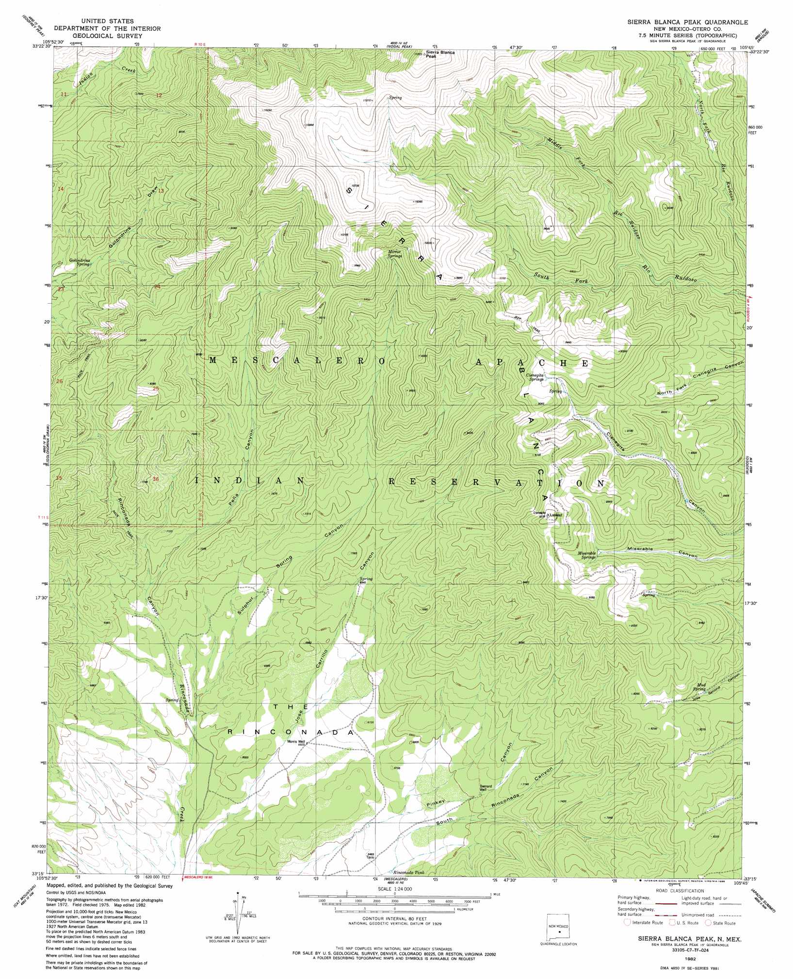
USGS Topo Quad 33105c7 - 1:24,000 scale
| Topo Map Name: | Sierra Blanca Peak |
| USGS Topo Quad ID: | 33105c7 |
| Print Size: | ca. 21 1/4" wide x 27" high |
| Southeast Coordinates: | 33.25° N latitude / 105.75° W longitude |
| Map Center Coordinates: | 33.3125° N latitude / 105.8125° W longitude |
| U.S. State: | NM |
| Filename: | o33105c7.jpg |
| Download Map JPG Image: | Sierra Blanca Peak topo map 1:24,000 scale |
| Map Type: | Topographic |
| Topo Series: | 7.5´ |
| Map Scale: | 1:24,000 |
| Source of Map Images: | United States Geological Survey (USGS) |
| Alternate Map Versions: |
Sierra Blanca Peak NM 1982, updated 1982 Download PDF Buy paper map Sierra Blanca Peak NM 1982, updated 1986 Download PDF Buy paper map Sierra Blanca Peak NM 2010 Download PDF Buy paper map Sierra Blanca Peak NM 2013 Download PDF Buy paper map |
| FStopo: | US Forest Service topo Sierra Blanca Peak is available: Download FStopo PDF Download FStopo TIF |
1:24,000 Topo Quads surrounding Sierra Blanca Peak
Bull Gap |
Cub Mountain |
Church Mountain |
Nogal |
Capitan |
Oscura |
Godfrey Peak |
Nogal Peak |
Angus |
Fort Stanton |
Three Rivers |
Golondrina Draw |
Sierra Blanca Peak |
Ruidoso |
Ruidoso Downs |
Tularosa Ne |
Cat Mountain |
Mescalero |
Apache Summit |
Whitetail |
Tularosa |
Sabinata Flat |
Domingo Peak |
Firman Canyon |
Elk-Silver |
> Back to 33105a1 at 1:100,000 scale
> Back to 33104a1 at 1:250,000 scale
> Back to U.S. Topo Maps home
Sierra Blanca Peak topo map: Gazetteer
Sierra Blanca Peak: Flats
The Rinconada elevation 1954m 6410′Sierra Blanca Peak: Parks
Sierra Blanca Historical Marker elevation 3625m 11893′Sierra Blanca Peak: Ranges
Sierra Blanca elevation 3634m 11922′Sierra Blanca Peak: Springs
Cienegita Springs elevation 2703m 8868′Golondrina Spring elevation 2102m 6896′
Miserable Springs elevation 2576m 8451′
Mud Spring elevation 2402m 7880′
Sierra Blanca Peak: Streams
Middle Fork Rio Ruidoso elevation 2436m 7992′Sierra Blanca Peak: Summits
Sierra Blanca Peak elevation 3625m 11893′Sierra Blanca Peak: Valleys
Peña Canyon elevation 2037m 6683′Sulphur Spring Canyon elevation 1936m 6351′
Sierra Blanca Peak: Wells
Bernard Well elevation 2092m 6863′Morris Well elevation 1979m 6492′
Sierra Blanca Peak digital topo map on disk
Buy this Sierra Blanca Peak topo map showing relief, roads, GPS coordinates and other geographical features, as a high-resolution digital map file on DVD: