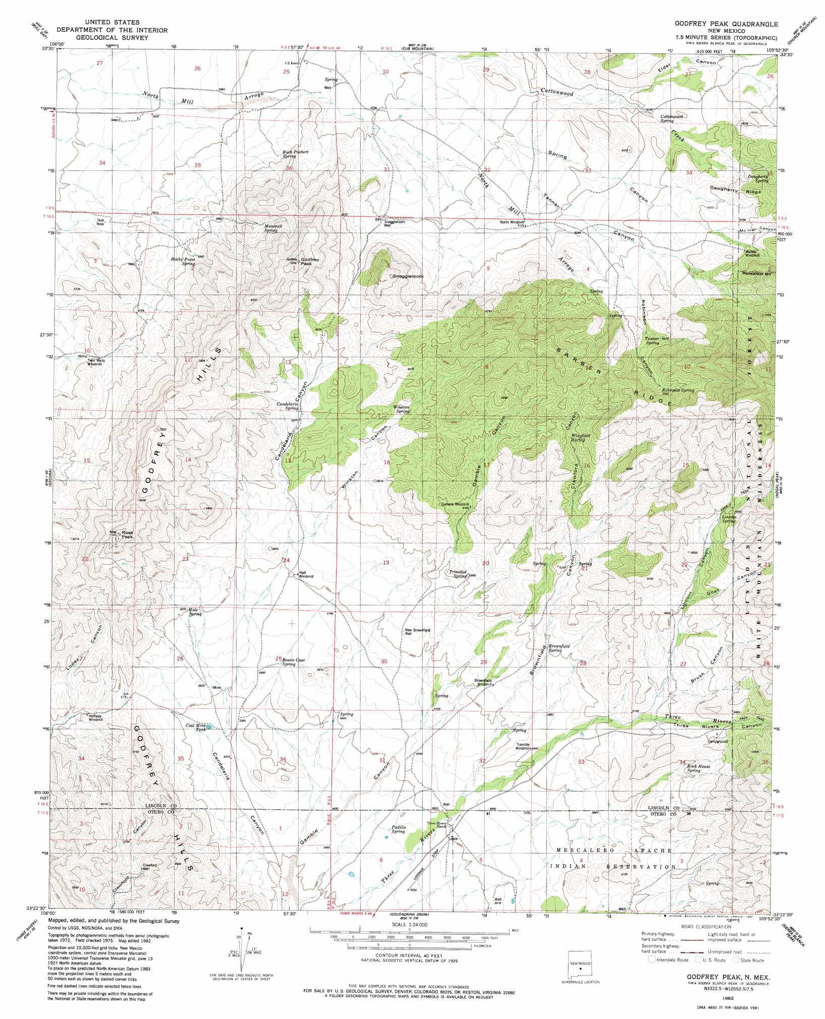
Godfrey Peak Topo Map New Mexico
To zoom in, hover over the map of Godfrey Peak
USGS Topo Quad 33105d8 - 1:24,000 scale
| Topo Map Name: | Godfrey Peak |
| USGS Topo Quad ID: | 33105d8 |
| Print Size: | ca. 21 1/4" wide x 27" high |
| Southeast Coordinates: | 33.375° N latitude / 105.875° W longitude |
| Map Center Coordinates: | 33.4375° N latitude / 105.9375° W longitude |
| U.S. State: | NM |
| Filename: | o33105d8.jpg |
| Download Map JPG Image: | Godfrey Peak topo map 1:24,000 scale |
| Map Type: | Topographic |
| Topo Series: | 7.5´ |
| Map Scale: | 1:24,000 |
| Source of Map Images: | United States Geological Survey (USGS) |
| Alternate Map Versions: |
Godfrey Peak NM 1982, updated 1982 Download PDF Buy paper map Godfrey Peak NM 2004, updated 2006 Download PDF Buy paper map Godfrey Peak NM 2011 Download PDF Buy paper map Godfrey Peak NM 2013 Download PDF Buy paper map |
| FStopo: | US Forest Service topo Godfrey Peak is available: Download FStopo PDF Download FStopo TIF |
1:24,000 Topo Quads surrounding Godfrey Peak
Red Canyon |
Wagon Canyon |
Carrizoza West |
Carrizoza East |
White Oaks South |
Bull Gap Sw |
Bull Gap |
Cub Mountain |
Church Mountain |
Nogal |
Three Rivers Nw |
Oscura |
Godfrey Peak |
Nogal Peak |
Angus |
Three Rivers Sw |
Three Rivers |
Golondrina Draw |
Sierra Blanca Peak |
Ruidoso |
Bitter Creek |
Tularosa Ne |
Cat Mountain |
Mescalero |
Apache Summit |
> Back to 33105a1 at 1:100,000 scale
> Back to 33104a1 at 1:250,000 scale
> Back to U.S. Topo Maps home
Godfrey Peak topo map: Gazetteer
Godfrey Peak: Ranges
Godfrey Hills elevation 2198m 7211′Godfrey Peak: Reservoirs
Coal Mine Tank elevation 1696m 5564′Godfrey Peak: Ridges
Barber Ridge elevation 2525m 8284′Daugherty Ridge elevation 2076m 6811′
Godfrey Peak: Springs
Bessie Case Spring elevation 1725m 5659′Brownfield Spring elevation 1818m 5964′
Buck Pasture Spring elevation 1751m 5744′
Candelaria Spring elevation 1840m 6036′
Cottonwood Spring elevation 1897m 6223′
Daugherty Spring elevation 2063m 6768′
Hide Spring elevation 1829m 6000′
I Bar X Spring elevation 1741m 5711′
Lincoln Spring elevation 2055m 6742′
Maverick Spring elevation 1853m 6079′
Padilla Spring elevation 1685m 5528′
Robinson Spring elevation 2099m 6886′
Rock House Spring elevation 1883m 6177′
Rocky Point Spring elevation 1781m 5843′
Tanner Spring elevation 2036m 6679′
Trinidad Spring elevation 1829m 6000′
Wingfield Spring elevation 1987m 6519′
Winston Spring elevation 1921m 6302′
Godfrey Peak: Summits
Godfrey Peak elevation 2181m 7155′Rose Peak elevation 2167m 7109′
Snaggletooth elevation 2078m 6817′
Godfrey Peak: Valleys
Brownfield Canyon elevation 1718m 5636′Brush Canyon elevation 1873m 6145′
Candelaria Canyon elevation 1640m 5380′
Crawford Canyon elevation 1898m 6227′
Elder Canyon elevation 1870m 6135′
Gamble Canyon elevation 1640m 5380′
Goat Canyon elevation 1964m 6443′
Lincoln Canyon elevation 1858m 6095′
Mc Iver Canyon elevation 2064m 6771′
Rattlesnake Canyon elevation 2162m 7093′
Robinson Canyon elevation 1912m 6272′
Tanner Canyon elevation 1770m 5807′
Winston Canyon elevation 1816m 5958′
Godfrey Peak: Wells
Crawford Well elevation 1712m 5616′New Brownfield Well elevation 1783m 5849′
Snaggletooth Well elevation 1830m 6003′
Godfrey Peak digital topo map on disk
Buy this Godfrey Peak topo map showing relief, roads, GPS coordinates and other geographical features, as a high-resolution digital map file on DVD: