Strawberry Peak Topo Map New Mexico
To zoom in, hover over the map of Strawberry Peak
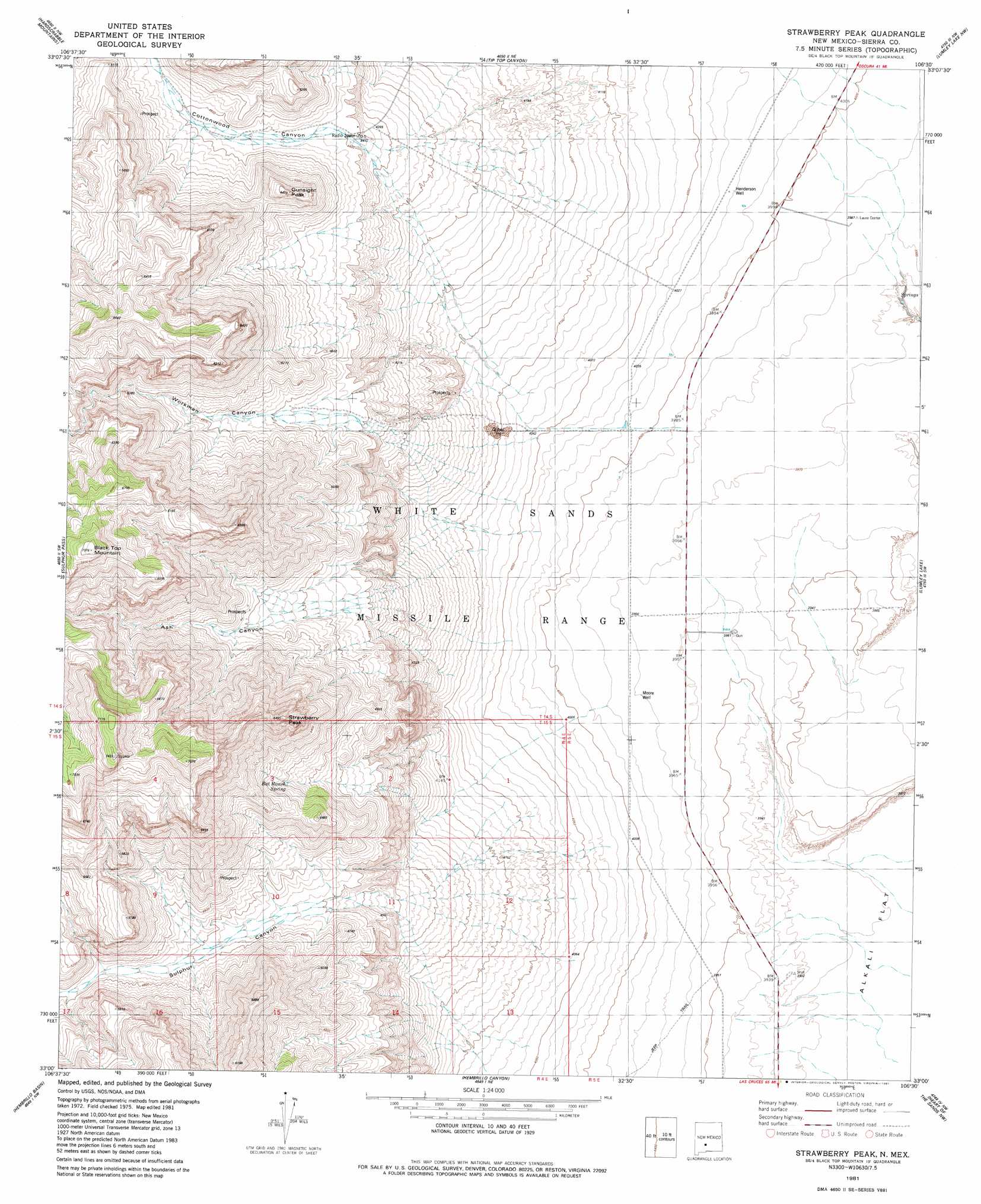
USGS Topo Quad 33106a5 - 1:24,000 scale
| Topo Map Name: | Strawberry Peak |
| USGS Topo Quad ID: | 33106a5 |
| Print Size: | ca. 21 1/4" wide x 27" high |
| Southeast Coordinates: | 33° N latitude / 106.5° W longitude |
| Map Center Coordinates: | 33.0625° N latitude / 106.5625° W longitude |
| U.S. State: | NM |
| Filename: | o33106a5.jpg |
| Download Map JPG Image: | Strawberry Peak topo map 1:24,000 scale |
| Map Type: | Topographic |
| Topo Series: | 7.5´ |
| Map Scale: | 1:24,000 |
| Source of Map Images: | United States Geological Survey (USGS) |
| Alternate Map Versions: |
Strawberry Peak NM 1981, updated 1981 Download PDF Buy paper map Strawberry Peak NM 2010 Download PDF Buy paper map Strawberry Peak NM 2013 Download PDF Buy paper map Strawberry Peak NM 2017 Download PDF Buy paper map |
1:24,000 Topo Quads surrounding Strawberry Peak
Fence Canyon |
Big Gyp Mountain |
Salinas Peak |
Sheep Mountain |
Capitol Peak Se |
Shannon Canyon |
Hardscrabble Mountains |
Tip Top Canyon |
Lumley Lake Nw |
Lumley Lake Ne |
Dugout Canyon |
Sulphur Pass |
Strawberry Peak |
Lumley Lake |
Fifteenmile Lake |
Prisor Well |
Hembrillo Basin |
Hembrillo Canyon |
Heart Of The Sands Nw |
Heart Of The Sands Ne |
Gilmore Draw |
Fleck Draw |
Gardner Peak |
Heart Of The Sands Sw |
Heart Of The Sands |
> Back to 33106a1 at 1:100,000 scale
> Back to 33106a1 at 1:250,000 scale
> Back to U.S. Topo Maps home
Strawberry Peak topo map: Gazetteer
Strawberry Peak: Mines
Cave Spar elevation 1590m 5216′Governor Group elevation 1378m 4520′
Harding Deposit elevation 1402m 4599′
Independence Mine elevation 1445m 4740′
Sulphur Canyon elevation 1499m 4917′
Strawberry Peak: Springs
Bat Ranch Spring elevation 1530m 5019′Eagle Nest Spring elevation 1852m 6076′
Strawberry Peak: Summits
Black Top Mountain elevation 2147m 7043′Gunsight Peak elevation 1653m 5423′
Strawberry Peak elevation 1924m 6312′
Strawberry Peak: Valleys
Ash Canyon elevation 1266m 4153′Cottonwood Canyon elevation 1336m 4383′
Quemado Canyon elevation 1450m 4757′
Sulphur Canyon elevation 1235m 4051′
Workman Canyon elevation 1267m 4156′
Strawberry Peak: Wells
Henderson Well elevation 1226m 4022′Moore Well elevation 1211m 3973′
Nelson Well elevation 1221m 4005′
Strawberry Peak digital topo map on disk
Buy this Strawberry Peak topo map showing relief, roads, GPS coordinates and other geographical features, as a high-resolution digital map file on DVD: