Sheep Mountain Topo Map New Mexico
To zoom in, hover over the map of Sheep Mountain
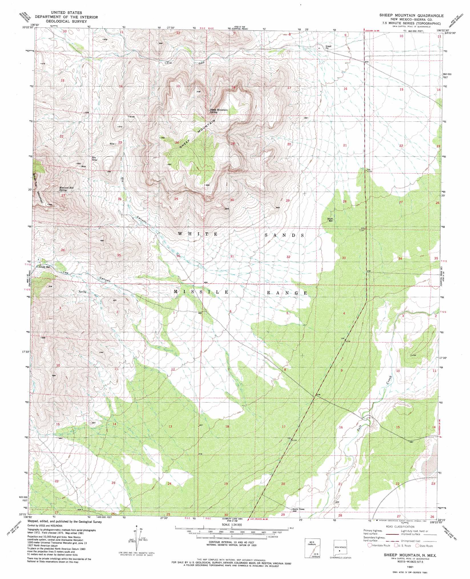
USGS Topo Quad 33106c4 - 1:24,000 scale
| Topo Map Name: | Sheep Mountain |
| USGS Topo Quad ID: | 33106c4 |
| Print Size: | ca. 21 1/4" wide x 27" high |
| Southeast Coordinates: | 33.25° N latitude / 106.375° W longitude |
| Map Center Coordinates: | 33.3125° N latitude / 106.4375° W longitude |
| U.S. State: | NM |
| Filename: | o33106c4.jpg |
| Download Map JPG Image: | Sheep Mountain topo map 1:24,000 scale |
| Map Type: | Topographic |
| Topo Series: | 7.5´ |
| Map Scale: | 1:24,000 |
| Source of Map Images: | United States Geological Survey (USGS) |
| Alternate Map Versions: |
Sheep Mountain NM 1981, updated 1982 Download PDF Buy paper map Sheep Mountain NM 2010 Download PDF Buy paper map Sheep Mountain NM 2013 Download PDF Buy paper map Sheep Mountain NM 2017 Download PDF Buy paper map |
1:24,000 Topo Quads surrounding Sheep Mountain
Blakemore Well |
Foster Well |
Mockingbird Gap |
Mockingbird Gap Se |
Bull Gap Sw |
Salinas Peak Nw |
Fairview Mountain |
Capitol Peak |
Mound Springs |
Three Rivers Nw |
Big Gyp Mountain |
Salinas Peak |
Sheep Mountain |
Capitol Peak Se |
Three Rivers Sw |
Hardscrabble Mountains |
Tip Top Canyon |
Lumley Lake Nw |
Lumley Lake Ne |
Bitter Creek |
Sulphur Pass |
Strawberry Peak |
Lumley Lake |
Fifteenmile Lake |
Tularosa Peak |
> Back to 33106a1 at 1:100,000 scale
> Back to 33106a1 at 1:250,000 scale
> Back to U.S. Topo Maps home
Sheep Mountain topo map: Gazetteer
Sheep Mountain: Gaps
Lava Gap elevation 1460m 4790′Sly Gap elevation 1662m 5452′
Sheep Mountain: Reservoirs
Joe West Tank elevation 1606m 5269′Sheep Mountain: Springs
Lee Canyon Spring elevation 1572m 5157′Mexican Hat Spring elevation 1876m 6154′
Sheep Mountain Spring elevation 1918m 6292′
Sheep Mountain: Summits
Sheep Mountain elevation 2099m 6886′Sheep Mountain: Valleys
Lee Canyon elevation 1448m 4750′Sly Canyon elevation 1372m 4501′
Thoroughgood Canyon elevation 1399m 4589′
Thurgood Canyon elevation 1393m 4570′
Sheep Mountain: Wells
Juniper Well elevation 1655m 5429′South Well elevation 1279m 4196′
Sheep Mountain digital topo map on disk
Buy this Sheep Mountain topo map showing relief, roads, GPS coordinates and other geographical features, as a high-resolution digital map file on DVD: