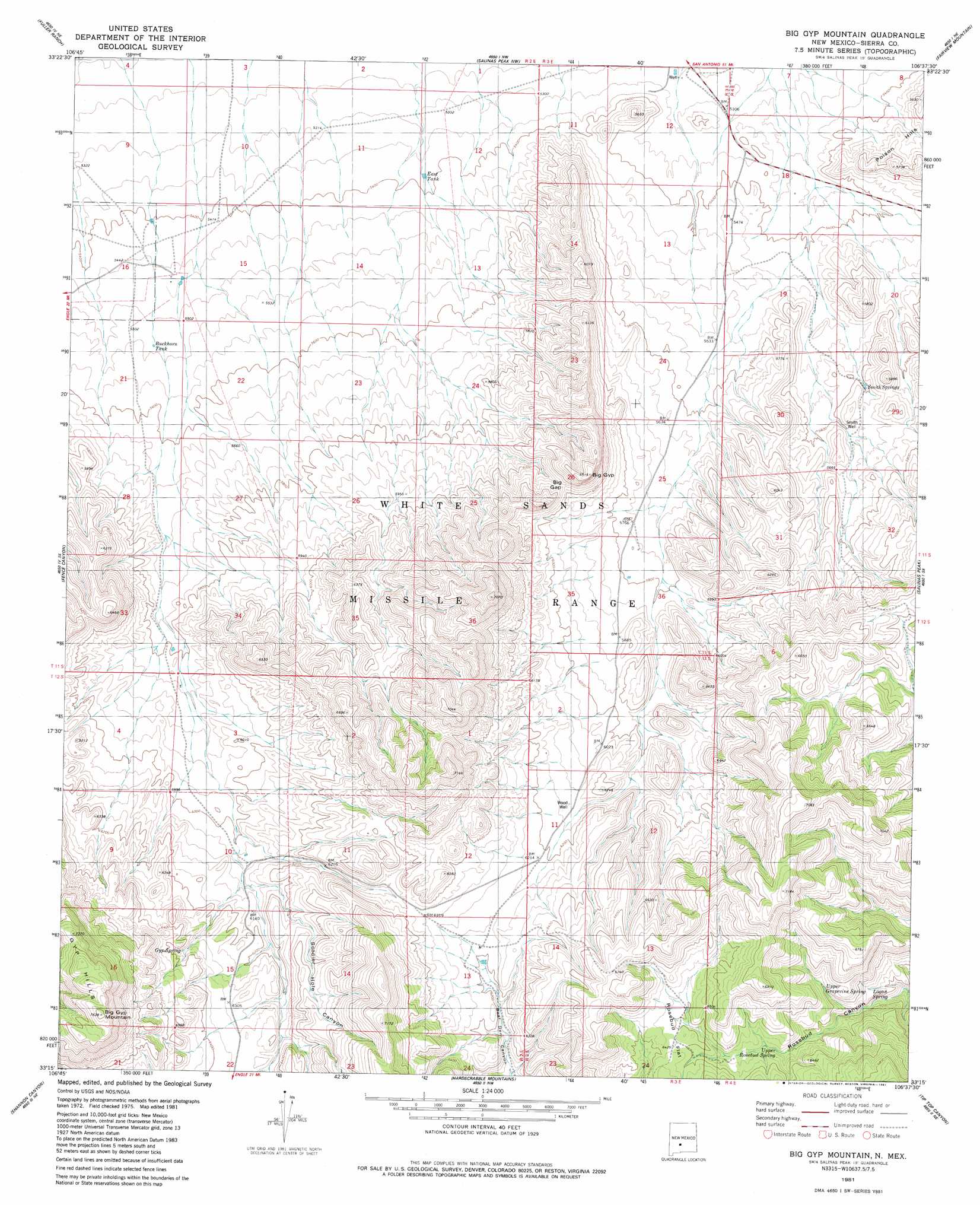
Big Gyp Mountain Topo Map New Mexico
To zoom in, hover over the map of Big Gyp Mountain
USGS Topo Quad 33106c6 - 1:24,000 scale
| Topo Map Name: | Big Gyp Mountain |
| USGS Topo Quad ID: | 33106c6 |
| Print Size: | ca. 21 1/4" wide x 27" high |
| Southeast Coordinates: | 33.25° N latitude / 106.625° W longitude |
| Map Center Coordinates: | 33.3125° N latitude / 106.6875° W longitude |
| U.S. State: | NM |
| Filename: | o33106c6.jpg |
| Download Map JPG Image: | Big Gyp Mountain topo map 1:24,000 scale |
| Map Type: | Topographic |
| Topo Series: | 7.5´ |
| Map Scale: | 1:24,000 |
| Source of Map Images: | United States Geological Survey (USGS) |
| Alternate Map Versions: |
Big Gyp Mountain NM 1981, updated 1981 Download PDF Buy paper map Big Gyp Mountain NM 2010 Download PDF Buy paper map Big Gyp Mountain NM 2013 Download PDF Buy paper map Big Gyp Mountain NM 2017 Download PDF Buy paper map |
1:24,000 Topo Quads surrounding Big Gyp Mountain
Pope |
Harriet Ranch |
Blakemore Well |
Foster Well |
Mockingbird Gap |
Tucson Spring |
Fuller Ranch |
Salinas Peak Nw |
Fairview Mountain |
Capitol Peak |
Fairview Well |
Fence Canyon |
Big Gyp Mountain |
Salinas Peak |
Sheep Mountain |
Shannon Canyon Nw |
Shannon Canyon |
Hardscrabble Mountains |
Tip Top Canyon |
Lumley Lake Nw |
Polecat Tank |
Dugout Canyon |
Sulphur Pass |
Strawberry Peak |
Lumley Lake |
> Back to 33106a1 at 1:100,000 scale
> Back to 33106a1 at 1:250,000 scale
> Back to U.S. Topo Maps home
Big Gyp Mountain topo map: Gazetteer
Big Gyp Mountain: Gaps
Big Gap elevation 1859m 6099′Big Gyp Mountain: Reservoirs
Buckhorn Tank elevation 1678m 5505′East Tank elevation 1644m 5393′
Big Gyp Mountain: Springs
Distill Spring elevation 1902m 6240′Gyp Spring elevation 1913m 6276′
Logan Spring elevation 1852m 6076′
Smith Springs elevation 1707m 5600′
Upper Grapevine Spring elevation 1870m 6135′
Upper Rosebud Spring elevation 1916m 6286′
Big Gyp Mountain: Summits
Big Gyp elevation 1972m 6469′Big Gyp Mountain elevation 2271m 7450′
Big Gyp Mountain: Valleys
Cottonwood Canyon elevation 1633m 5357′Soldier Hole Canyon elevation 1853m 6079′
Big Gyp Mountain: Wells
Smith Well elevation 1707m 5600′Wood Well elevation 1872m 6141′
Big Gyp Mountain digital topo map on disk
Buy this Big Gyp Mountain topo map showing relief, roads, GPS coordinates and other geographical features, as a high-resolution digital map file on DVD: