Wrye Peak Sw Topo Map New Mexico
To zoom in, hover over the map of Wrye Peak Sw
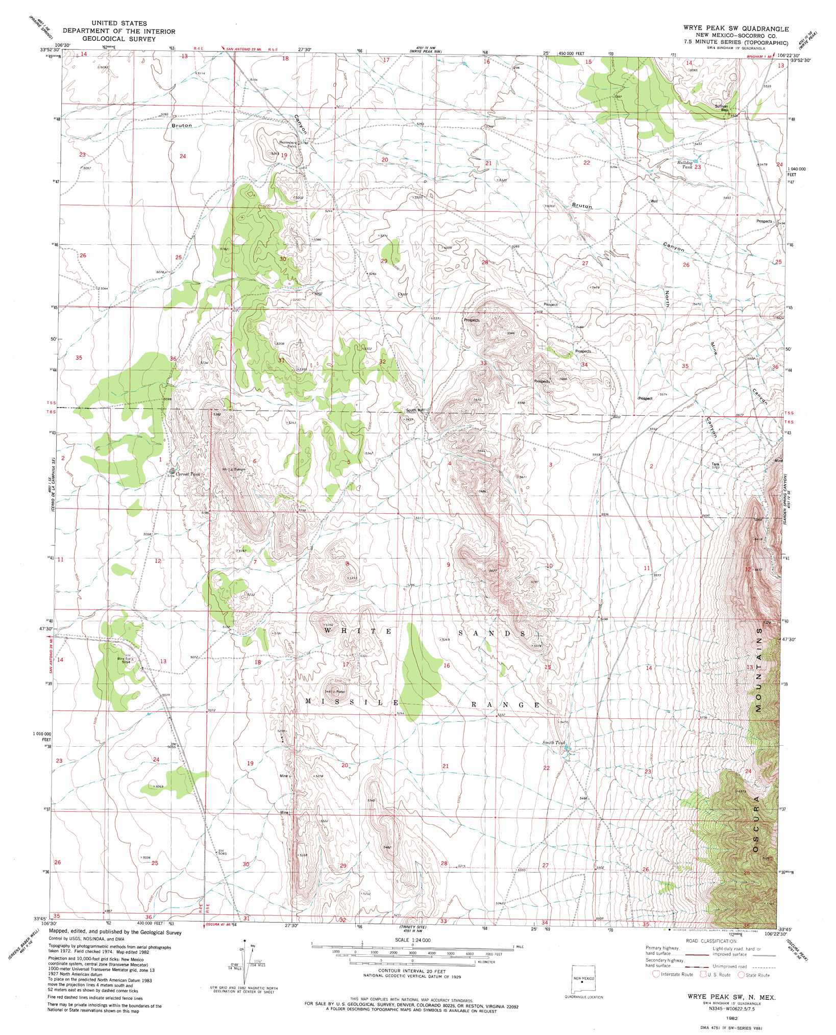
USGS Topo Quad 33106g4 - 1:24,000 scale
| Topo Map Name: | Wrye Peak Sw |
| USGS Topo Quad ID: | 33106g4 |
| Print Size: | ca. 21 1/4" wide x 27" high |
| Southeast Coordinates: | 33.75° N latitude / 106.375° W longitude |
| Map Center Coordinates: | 33.8125° N latitude / 106.4375° W longitude |
| U.S. State: | NM |
| Filename: | o33106g4.jpg |
| Download Map JPG Image: | Wrye Peak Sw topo map 1:24,000 scale |
| Map Type: | Topographic |
| Topo Series: | 7.5´ |
| Map Scale: | 1:24,000 |
| Source of Map Images: | United States Geological Survey (USGS) |
| Alternate Map Versions: |
Wrye Peak SW NM 1982, updated 1982 Download PDF Buy paper map Wrye Peak SW NM 2010 Download PDF Buy paper map Wrye Peak SW NM 2013 Download PDF Buy paper map Wrye Peak SW NM 2017 Download PDF Buy paper map |
1:24,000 Topo Quads surrounding Wrye Peak Sw
Bustos Well |
Sierra Larga South |
Orndorff Ranch |
Wilson Ranch |
Turkey Ridge Sw |
Canon Agua Buena |
Prairie Spring |
Wrye Peak Nw |
Wrye Peak |
Cooper Canyon |
Cerro De La Campana |
Cerro De La Campana Se |
Wrye Peak Sw |
Garden Spring Canyon |
Pink Peak |
Granjean Well |
Greens Baber Well |
Trinity Site |
Oscura Peak |
Red Canyon |
Blakemore Well |
Foster Well |
Mockingbird Gap |
Mockingbird Gap Se |
Bull Gap Sw |
> Back to 33106e1 at 1:100,000 scale
> Back to 33106a1 at 1:250,000 scale
> Back to U.S. Topo Maps home
Wrye Peak Sw topo map: Gazetteer
Wrye Peak Sw: Mines
Blanchard Mine elevation 1949m 6394′Farris Pit Number 1 elevation 1775m 5823′
Miera Prospect elevation 1972m 6469′
Wrye Peak Sw: Reservoirs
Bulldog Tank elevation 1656m 5433′Cornet Tank elevation 1553m 5095′
Smith Tank elevation 1653m 5423′
Wrye Peak Sw: Wells
Smith Well elevation 1705m 5593′Sullivan Well elevation 1677m 5501′
Wrye Peak Sw digital topo map on disk
Buy this Wrye Peak Sw topo map showing relief, roads, GPS coordinates and other geographical features, as a high-resolution digital map file on DVD: