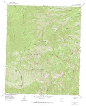
Victoria Park Topo Map New Mexico
To zoom in, hover over the map of Victoria Park
USGS Topo Quad 33107a7 - 1:24,000 scale
| Topo Map Name: | Victoria Park |
| USGS Topo Quad ID: | 33107a7 |
| Print Size: | ca. 21 1/4" wide x 27" high |
| Southeast Coordinates: | 33° N latitude / 107.75° W longitude |
| Map Center Coordinates: | 33.0625° N latitude / 107.8125° W longitude |
| U.S. State: | NM |
| Filename: | o33107a7.jpg |
| Download Map JPG Image: | Victoria Park topo map 1:24,000 scale |
| Map Type: | Topographic |
| Topo Series: | 7.5´ |
| Map Scale: | 1:24,000 |
| Source of Map Images: | United States Geological Survey (USGS) |
| Alternate Map Versions: |
Victoria Park NM 1963, updated 1965 Download PDF Buy paper map Victoria Park NM 1963, updated 1965 Download PDF Buy paper map Victorio Park NM 1999, updated 2002 Download PDF Buy paper map Victorio Park NM 2011 Download PDF Buy paper map Victorio Park NM 2013 Download PDF Buy paper map Victorio Park NM 2017 Download PDF Buy paper map |
| FStopo: | US Forest Service topo Victorio Park is available: Download FStopo PDF Download FStopo TIF |
1:24,000 Topo Quads surrounding Victoria Park
> Back to 33107a1 at 1:100,000 scale
> Back to 33106a1 at 1:250,000 scale
> Back to U.S. Topo Maps home
Victoria Park topo map: Gazetteer
Victoria Park: Areas
Gooseberry elevation 2147m 7043′Victoria Park: Flats
Victorio Park elevation 2173m 7129′Victoria Park: Gaps
Board Gate Saddle elevation 2863m 9393′Victoria Park: Lakes
Mimbres Lake elevation 2938m 9639′Mud Lake elevation 2339m 7673′
The Lakes elevation 2063m 6768′
Victoria Park: Populated Places
Murphy Place elevation 1996m 6548′Victoria Park: Springs
Deadman Spring elevation 2120m 6955′Geronimo Spring elevation 2441m 8008′
Marshall Spring elevation 2105m 6906′
McKnight Cabin Spring elevation 2898m 9507′
McKnight Pasture Spring elevation 2898m 9507′
Middle Seco Spring elevation 2229m 7312′
Negro Bill Spring elevation 2145m 7037′
North Seco Spring elevation 2825m 9268′
Ridge Spring elevation 2852m 9356′
Wild Cow Spring elevation 2226m 7303′
Willow Spring elevation 2941m 9648′
Victoria Park: Streams
Holden Prong elevation 2009m 6591′Sids Prong elevation 2180m 7152′
South Fork North Seco Creek elevation 2156m 7073′
Victoria Park: Summits
Granite Peak elevation 2830m 9284′McKnight Mountain elevation 3096m 10157′
Victorio Park Mountain elevation 2723m 8933′
Victoria Park: Valleys
East Curtis Canyon elevation 2093m 6866′Falls Gulch elevation 2036m 6679′
Flower Canyon elevation 2034m 6673′
Long Canyon elevation 2111m 6925′
Massacre Canyon elevation 1902m 6240′
Pretty Canyon elevation 2391m 7844′
Sand Canyon elevation 2004m 6574′
Victorio Park Canyon elevation 1952m 6404′
Water Canyon elevation 2072m 6797′
West Curtis Canyon elevation 1984m 6509′
Victoria Park digital topo map on disk
Buy this Victoria Park topo map showing relief, roads, GPS coordinates and other geographical features, as a high-resolution digital map file on DVD:


