Monticello Topo Map New Mexico
To zoom in, hover over the map of Monticello
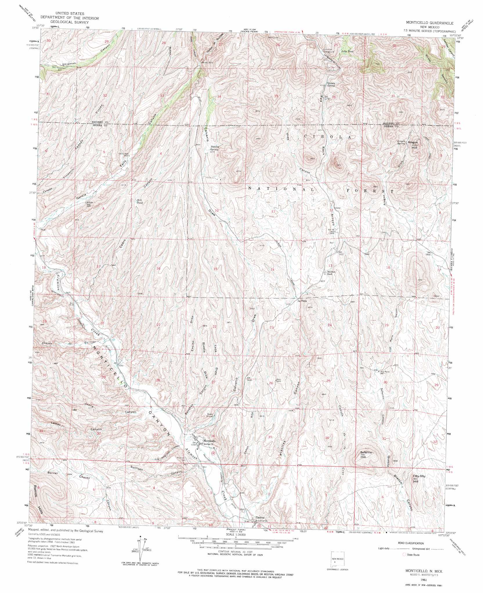
USGS Topo Quad 33107d4 - 1:24,000 scale
| Topo Map Name: | Monticello |
| USGS Topo Quad ID: | 33107d4 |
| Print Size: | ca. 21 1/4" wide x 27" high |
| Southeast Coordinates: | 33.375° N latitude / 107.375° W longitude |
| Map Center Coordinates: | 33.4375° N latitude / 107.4375° W longitude |
| U.S. State: | NM |
| Filename: | o33107d4.jpg |
| Download Map JPG Image: | Monticello topo map 1:24,000 scale |
| Map Type: | Topographic |
| Topo Series: | 7.5´ |
| Map Scale: | 1:24,000 |
| Source of Map Images: | United States Geological Survey (USGS) |
| Alternate Map Versions: |
Monticello NM 1961, updated 1964 Download PDF Buy paper map Monticello NM 1961, updated 1975 Download PDF Buy paper map Monticello NM 1995, updated 1998 Download PDF Buy paper map Monticello NM 2011 Download PDF Buy paper map Monticello NM 2013 Download PDF Buy paper map Monticello NM 2017 Download PDF Buy paper map |
| FStopo: | US Forest Service topo Monticello is available: Download FStopo PDF Download FStopo TIF |
1:24,000 Topo Quads surrounding Monticello
Dusty |
Welty Hill |
Blue Mountain |
San Juan Peak |
Hickman Ranch |
Wahoo Ranch |
Montoya Butte |
Vicks Peak |
Steel Hill |
Black Hill |
Iron Mountain |
Jaralosa Mountain |
Monticello |
Sierra Fijardo |
Romero Canyon |
Winston |
Chise |
Priest Tank |
Huerfano Hill |
Black Bluffs |
Sugarloaf Peak |
Thumb Tank Peak |
Williamsburg Nw |
Cuchillo |
Elephant Butte |
> Back to 33107a1 at 1:100,000 scale
> Back to 33106a1 at 1:250,000 scale
> Back to U.S. Topo Maps home
Monticello topo map: Gazetteer
Monticello: Arroyos
Cañada de Quirino elevation 1639m 5377′Monticello: Canals
Monticello Community Ditch elevation 1652m 5419′Monticello: Falls
Garcia Falls elevation 1893m 6210′Monticello: Mines
Goldsborough 1 Mine elevation 1987m 6519′Goldsborough 2 Mine elevation 1987m 6519′
Goldsborough 3 Mine elevation 1987m 6519′
Goldsborough 4 Mine elevation 1987m 6519′
Goldsborough District elevation 1910m 6266′
Negro Diggings elevation 2102m 6896′
Terry Prospect elevation 1735m 5692′
Monticello: Populated Places
La Petra elevation 1755m 5757′Monticello elevation 1602m 5255′
Placitas elevation 1586m 5203′
Monticello: Post Offices
Monticello Post Office elevation 1602m 5255′Monticello: Reservoirs
Alamo Tank elevation 1948m 6391′Bill Tank elevation 1833m 6013′
Jolla Tank elevation 2019m 6624′
Lumber Tank elevation 1989m 6525′
Monticello Number One Tank elevation 1808m 5931′
Monticello Number Two Tank elevation 1753m 5751′
Stanley Tank elevation 1836m 6023′
Stanley Well elevation 1811m 5941′
Monticello: Springs
Aragon Spring elevation 1911m 6269′East Monticello Spring elevation 1908m 6259′
Garcia Falls Spring elevation 1872m 6141′
Las Uvas Spring elevation 1933m 6341′
Questa Spring elevation 1926m 6318′
Stanley Spring elevation 1898m 6227′
Monticello: Summits
Aragon Hill elevation 2015m 6610′Fifty-fifty Hill elevation 1717m 5633′
La Questa de Trujillo elevation 2049m 6722′
Seferino Hill elevation 1791m 5875′
Monticello: Valleys
Calvario Draw elevation 1604m 5262′Cañon de Quirino elevation 1881m 6171′
Cañon Rita elevation 1586m 5203′
Cedro Canyon elevation 1651m 5416′
Deep Canyon elevation 1881m 6171′
Encino Draw elevation 1662m 5452′
Jose Maria Canyon elevation 1699m 5574′
Juana Canyon elevation 1615m 5298′
Lemes Canyon elevation 1613m 5291′
Los Negritos Canyon elevation 1598m 5242′
Middle Draw elevation 1686m 5531′
Placitas Canyon elevation 1583m 5193′
Red Rock Arroyo elevation 1743m 5718′
Sanchez Canyon elevation 1609m 5278′
Seferino Canyon elevation 1662m 5452′
Sullivan Canyon elevation 1597m 5239′
Tank Draw elevation 1686m 5531′
Uvas Canyon elevation 1847m 6059′
Monticello: Wells
Aragon Well elevation 1994m 6541′Bar Forty-Four Well elevation 1814m 5951′
Garcia Well elevation 1778m 5833′
Jose Maria Well elevation 1701m 5580′
Questa Well elevation 1926m 6318′
RG 24237 Water Well elevation 1632m 5354′
RG 24355C Water Well elevation 1652m 5419′
RG 27650 Water Well elevation 1604m 5262′
RG 31106 Water Well elevation 1628m 5341′
Shipman Well elevation 1851m 6072′
Wilhite Well elevation 1731m 5679′
Monticello digital topo map on disk
Buy this Monticello topo map showing relief, roads, GPS coordinates and other geographical features, as a high-resolution digital map file on DVD: