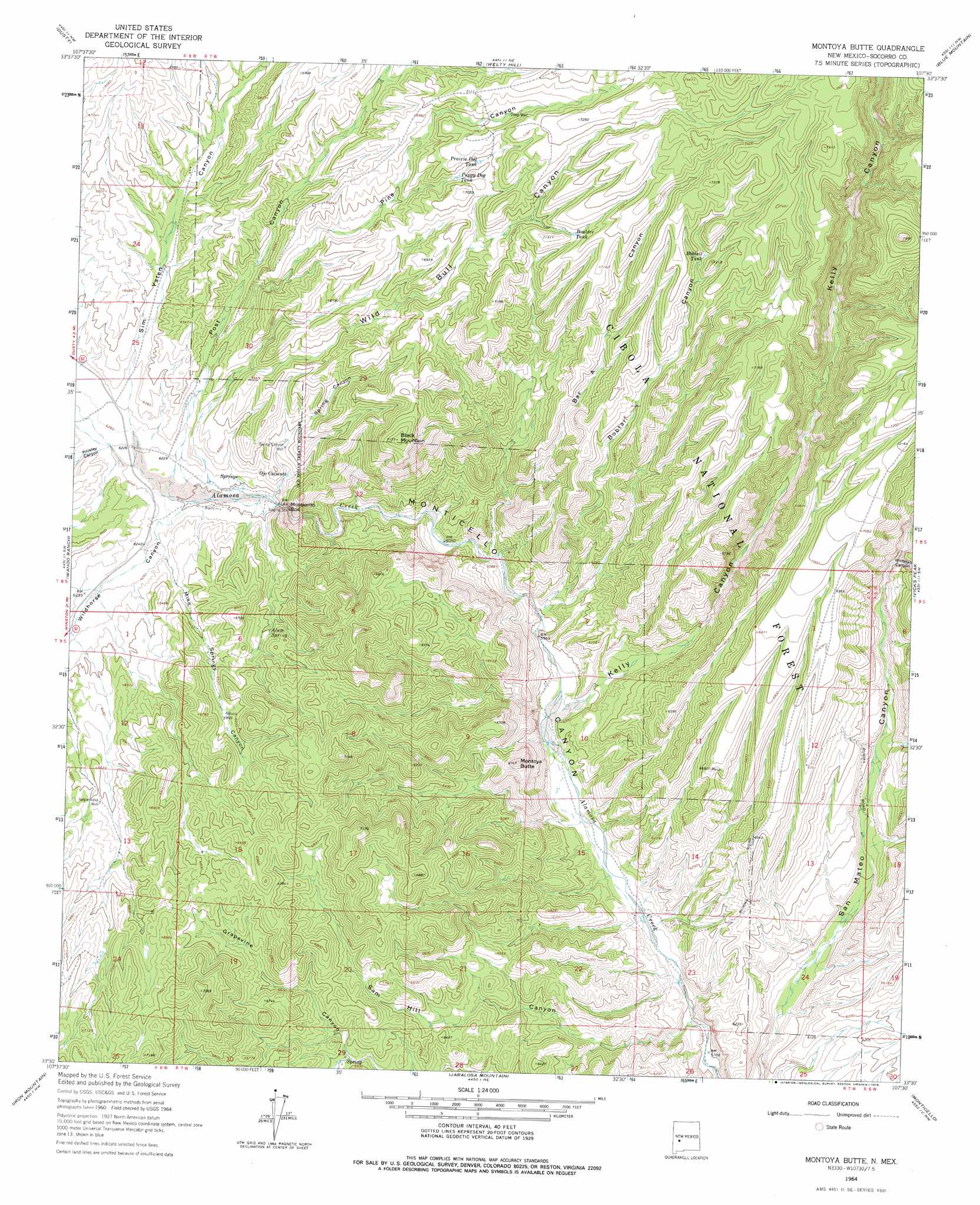
Montoya Butte Topo Map New Mexico
To zoom in, hover over the map of Montoya Butte
USGS Topo Quad 33107e5 - 1:24,000 scale
| Topo Map Name: | Montoya Butte |
| USGS Topo Quad ID: | 33107e5 |
| Print Size: | ca. 21 1/4" wide x 27" high |
| Southeast Coordinates: | 33.5° N latitude / 107.5° W longitude |
| Map Center Coordinates: | 33.5625° N latitude / 107.5625° W longitude |
| U.S. State: | NM |
| Filename: | o33107e5.jpg |
| Download Map JPG Image: | Montoya Butte topo map 1:24,000 scale |
| Map Type: | Topographic |
| Topo Series: | 7.5´ |
| Map Scale: | 1:24,000 |
| Source of Map Images: | United States Geological Survey (USGS) |
| Alternate Map Versions: |
Montoya Butte NM 1964, updated 1966 Download PDF Buy paper map Montoya Butte NM 1964, updated 1978 Download PDF Buy paper map Montoya Butte NM 1995, updated 1998 Download PDF Buy paper map Montoya Butte NM 2011 Download PDF Buy paper map Montoya Butte NM 2013 Download PDF Buy paper map Montoya Butte NM 2017 Download PDF Buy paper map |
| FStopo: | US Forest Service topo Montoya Butte is available: Download FStopo PDF Download FStopo TIF |
1:24,000 Topo Quads surrounding Montoya Butte
Luera Mountains East |
Oak Peak |
Bay Buck Peaks |
Grassy Lookout |
Tenmile Hill |
Paddys Hole |
Dusty |
Welty Hill |
Blue Mountain |
San Juan Peak |
Wahoo Peak |
Wahoo Ranch |
Montoya Butte |
Vicks Peak |
Steel Hill |
Sawmill Peak |
Iron Mountain |
Jaralosa Mountain |
Monticello |
Sierra Fijardo |
Lookout Mountain |
Winston |
Chise |
Priest Tank |
Huerfano Hill |
> Back to 33107e1 at 1:100,000 scale
> Back to 33106a1 at 1:250,000 scale
> Back to U.S. Topo Maps home
Montoya Butte topo map: Gazetteer
Montoya Butte: Gaps
Monticello Box elevation 1880m 6167′Montoya Butte: Mines
Ojo Caliente Spring elevation 1890m 6200′Taylor elevation 2072m 6797′
Montoya Butte: Populated Places
Cherryville (historical) elevation 1894m 6213′Montoya Butte: Reservoirs
Bar A Tank elevation 2107m 6912′Bobtail Tank elevation 2169m 7116′
Boulder Tank elevation 2157m 7076′
Drift Fence Tank elevation 2192m 7191′
Elk Tank elevation 2121m 6958′
Flat Tank elevation 2110m 6922′
Park Tank elevation 2114m 6935′
Prairie Dog Tank elevation 2132m 6994′
Puppy Dog Tank elevation 2120m 6955′
Montoya Butte: Springs
Alum Spring elevation 1961m 6433′Ojo Caliente elevation 2077m 6814′
Ojo Caliente elevation 1912m 6272′
Montoya Butte: Summits
Black Mountain elevation 2184m 7165′Montoya Butte elevation 2032m 6666′
Montoya Butte: Valleys
Bar A Canyon elevation 1841m 6040′Bobtail Canyon elevation 1830m 6003′
Kelly Canyon elevation 1814m 5951′
Knisely Canyon elevation 1903m 6243′
Mike Springs Canyon elevation 1902m 6240′
Pine Canyon elevation 1936m 6351′
Post Canyon elevation 1941m 6368′
Sam Hill Canyon elevation 1763m 5784′
Sim Yaten Canyon elevation 1901m 6236′
Spring Canyon elevation 1882m 6174′
Whitetail Canyon elevation 1952m 6404′
Wild Bull Canyon elevation 1891m 6204′
Wildhorse Canyon elevation 1890m 6200′
Montoya Butte: Wells
Allison Well elevation 1998m 6555′Bennie Mil Water Well elevation 2050m 6725′
Deep Water Well elevation 2142m 7027′
Deep Well elevation 2144m 7034′
Rattlesnake Well elevation 2015m 6610′
Spring Canyon Well elevation 1946m 6384′
Montoya Butte digital topo map on disk
Buy this Montoya Butte topo map showing relief, roads, GPS coordinates and other geographical features, as a high-resolution digital map file on DVD: