Wahoo Ranch Topo Map New Mexico
To zoom in, hover over the map of Wahoo Ranch
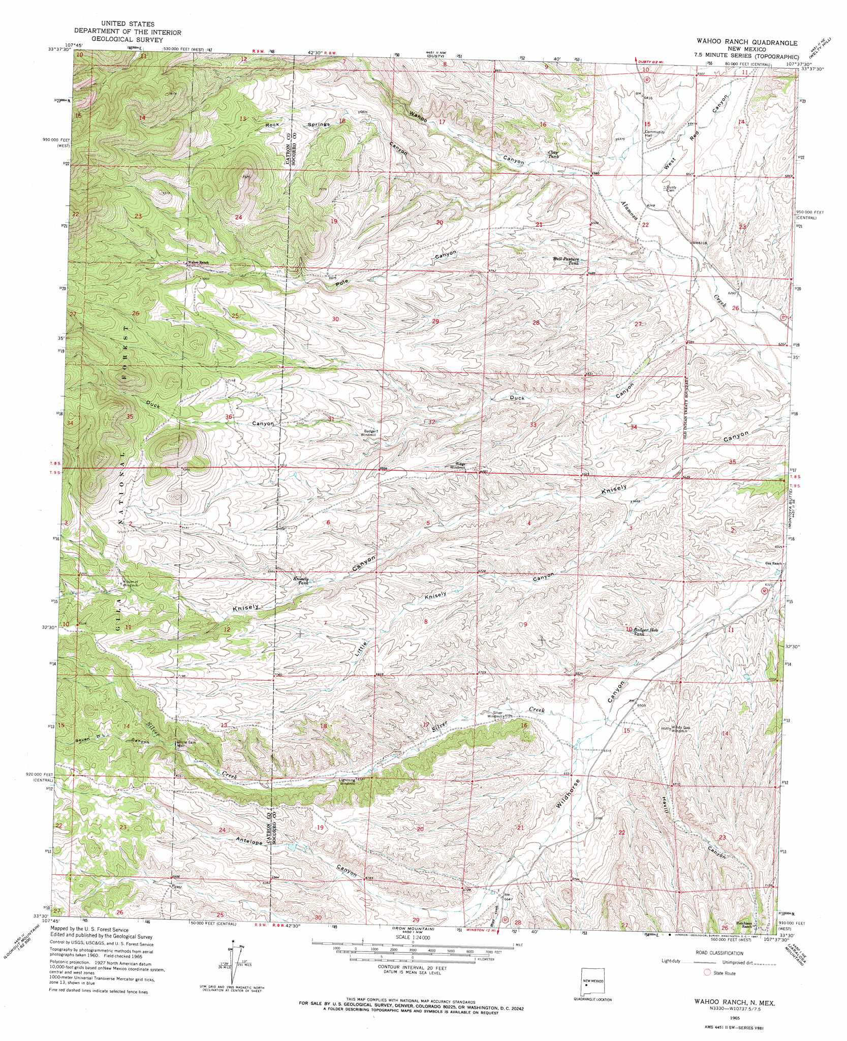
USGS Topo Quad 33107e6 - 1:24,000 scale
| Topo Map Name: | Wahoo Ranch |
| USGS Topo Quad ID: | 33107e6 |
| Print Size: | ca. 21 1/4" wide x 27" high |
| Southeast Coordinates: | 33.5° N latitude / 107.625° W longitude |
| Map Center Coordinates: | 33.5625° N latitude / 107.6875° W longitude |
| U.S. State: | NM |
| Filename: | o33107e6.jpg |
| Download Map JPG Image: | Wahoo Ranch topo map 1:24,000 scale |
| Map Type: | Topographic |
| Topo Series: | 7.5´ |
| Map Scale: | 1:24,000 |
| Source of Map Images: | United States Geological Survey (USGS) |
| Alternate Map Versions: |
Wahoo Ranch NM 1999, updated 2002 Download PDF Buy paper map Wahoo Ranch NM 2011 Download PDF Buy paper map Wahoo Ranch NM 2013 Download PDF Buy paper map Wahoo Ranch NM 2017 Download PDF Buy paper map |
| FStopo: | US Forest Service topo Wahoo Ranch is available: Download FStopo PDF Download FStopo TIF |
1:24,000 Topo Quads surrounding Wahoo Ranch
Luera Mountains West |
Luera Mountains East |
Oak Peak |
Bay Buck Peaks |
Grassy Lookout |
Mojonera Canyon |
Paddys Hole |
Dusty |
Welty Hill |
Blue Mountain |
Indian Peaks East |
Wahoo Peak |
Wahoo Ranch |
Montoya Butte |
Vicks Peak |
Taylor Peak |
Sawmill Peak |
Iron Mountain |
Jaralosa Mountain |
Monticello |
Baily Points |
Lookout Mountain |
Winston |
Chise |
Priest Tank |
> Back to 33107e1 at 1:100,000 scale
> Back to 33106a1 at 1:250,000 scale
> Back to U.S. Topo Maps home
Wahoo Ranch topo map: Gazetteer
Wahoo Ranch: Arroyos
Knisely elevation 2159m 7083′Little Knisley Canyon elevation 2122m 6961′
Wahoo Ranch: Populated Places
Dusty (historical) elevation 1948m 6391′Wahoo Ranch: Post Offices
Dusty Post Office (historical) elevation 1948m 6391′Wahoo Ranch: Reservoirs
Badger Hole Tank elevation 1980m 6496′Bull Pasture Tank elevation 1965m 6446′
Clay Tank elevation 1975m 6479′
Knisely Tank elevation 2089m 6853′
Wahoo Ranch: Streams
Hipp Creek elevation 2029m 6656′Silver Creek elevation 1979m 6492′
Wahoo Ranch: Valleys
Antelope Canyon elevation 2027m 6650′Duck Canyon elevation 1915m 6282′
Havill Canyon elevation 1979m 6492′
Little Knisely Canyon elevation 1946m 6384′
Pole Canyon elevation 1927m 6322′
Rock Springs Canyon elevation 1962m 6437′
Seven H L Canyon elevation 2116m 6942′
Wahoo Canyon elevation 1936m 6351′
West Red Canyon elevation 1937m 6354′
Wahoo Ranch: Wells
Badger Windmill Water Well elevation 2084m 6837′Folsby Water Well elevation 2026m 6646′
H Over H Water Well elevation 2167m 7109′
Headquaters Water Well elevation 1926m 6318′
Knisely Water Well elevation 2080m 6824′
Lighting Water Well elevation 2051m 6729′
Ridge Windmill Water Well elevation 2082m 6830′
Rock Spring Water Well elevation 2086m 6843′
Silver Windmill Water Well elevation 2010m 6594′
Uncle Sam Well elevation 2105m 6906′
Windy Gap Water Well elevation 2017m 6617′
Wahoo Ranch digital topo map on disk
Buy this Wahoo Ranch topo map showing relief, roads, GPS coordinates and other geographical features, as a high-resolution digital map file on DVD: