Dusty Topo Map New Mexico
To zoom in, hover over the map of Dusty
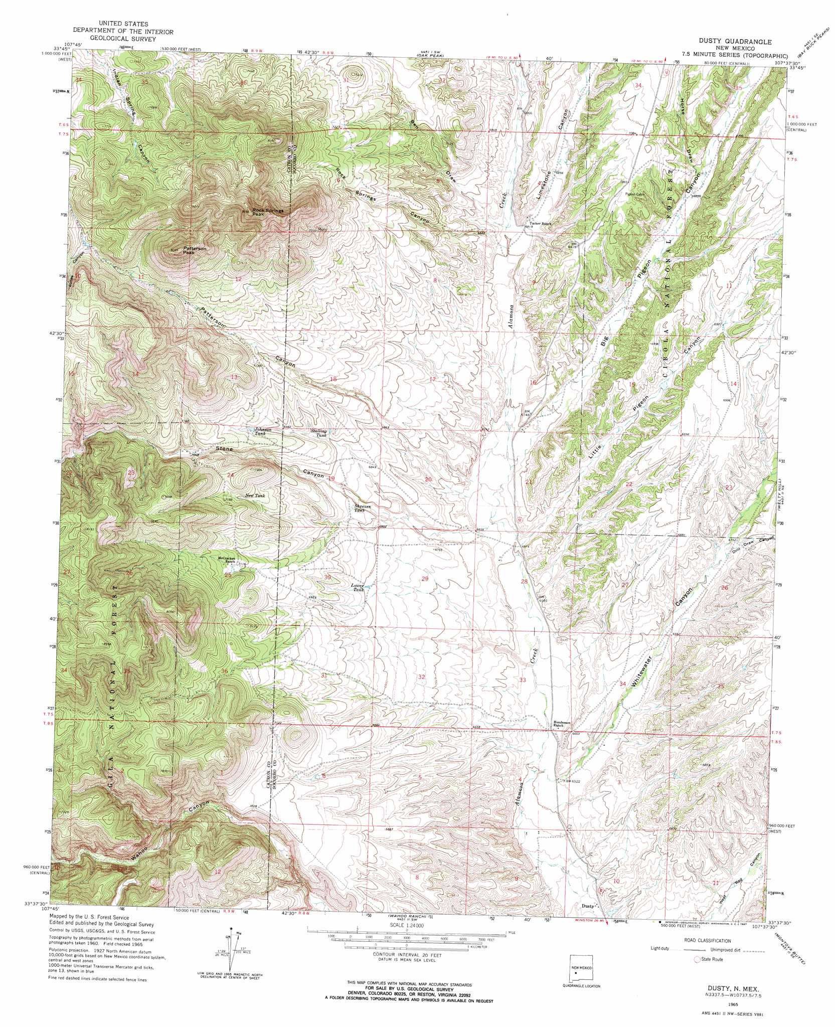
USGS Topo Quad 33107f6 - 1:24,000 scale
| Topo Map Name: | Dusty |
| USGS Topo Quad ID: | 33107f6 |
| Print Size: | ca. 21 1/4" wide x 27" high |
| Southeast Coordinates: | 33.625° N latitude / 107.625° W longitude |
| Map Center Coordinates: | 33.6875° N latitude / 107.6875° W longitude |
| U.S. State: | NM |
| Filename: | o33107f6.jpg |
| Download Map JPG Image: | Dusty topo map 1:24,000 scale |
| Map Type: | Topographic |
| Topo Series: | 7.5´ |
| Map Scale: | 1:24,000 |
| Source of Map Images: | United States Geological Survey (USGS) |
| Alternate Map Versions: |
Dusty NM 1965, updated 1967 Download PDF Buy paper map Dusty NM 1995, updated 1998 Download PDF Buy paper map Dusty NM 2005, updated 2006 Download PDF Buy paper map Dusty NM 2011 Download PDF Buy paper map Dusty NM 2013 Download PDF Buy paper map Dusty NM 2017 Download PDF Buy paper map |
| FStopo: | US Forest Service topo Dusty is available: Download FStopo PDF Download FStopo TIF |
1:24,000 Topo Quads surrounding Dusty
Luera Mountains Nw |
C-N Lake |
Kellog Well |
Monica Saddle |
Mount Withington |
Luera Mountains West |
Luera Mountains East |
Oak Peak |
Bay Buck Peaks |
Grassy Lookout |
Mojonera Canyon |
Paddys Hole |
Dusty |
Welty Hill |
Blue Mountain |
Indian Peaks East |
Wahoo Peak |
Wahoo Ranch |
Montoya Butte |
Vicks Peak |
Taylor Peak |
Sawmill Peak |
Iron Mountain |
Jaralosa Mountain |
Monticello |
> Back to 33107e1 at 1:100,000 scale
> Back to 33106a1 at 1:250,000 scale
> Back to U.S. Topo Maps home
Dusty topo map: Gazetteer
Dusty: Populated Places
Dusty elevation 1961m 6433′Dusty elevation 1962m 6437′
Dusty: Reservoirs
Hells Tank elevation 2275m 7463′Home Tank elevation 2242m 7355′
Johnson Tank elevation 2140m 7020′
Lower Pigeon Tank elevation 2074m 6804′
Lower Pigeon Tank elevation 2144m 7034′
Lower Tank elevation 2071m 6794′
New Tank elevation 2163m 7096′
Outlaw Tank elevation 2228m 7309′
Outlaw Tank elevation 2195m 7201′
Shreves Tank elevation 2081m 6827′
Snow Tank elevation 2432m 7979′
Spring Tank elevation 2290m 7513′
Spring Tank elevation 2281m 7483′
Stalling Tank elevation 2111m 6925′
Stock Tank elevation 2285m 7496′
Dusty: Summits
Patterson Peak elevation 2513m 8244′Rock Springs Peak elevation 2508m 8228′
Dusty: Valleys
Ben Draw elevation 2077m 6814′Big Pigeon Canyon elevation 2030m 6660′
Drill Draw Canyon elevation 2054m 6738′
Horse Draw elevation 2097m 6879′
Jones Canyon elevation 2277m 7470′
Limestone Canyon elevation 2074m 6804′
Little Pigeon Canyon elevation 2012m 6601′
Patterson Canyon elevation 2023m 6637′
Rock Springs Canyon elevation 2074m 6804′
Stone Canyon elevation 2019m 6624′
Sullivans Hole Canyon elevation 2074m 6804′
Whitewater Canyon elevation 1982m 6502′
Dusty: Wells
10016 Water Well elevation 2081m 6827′10017 Water Well elevation 2081m 6827′
10018 Water Well elevation 1961m 6433′
Dusty digital topo map on disk
Buy this Dusty topo map showing relief, roads, GPS coordinates and other geographical features, as a high-resolution digital map file on DVD: