Tenmile Hill Topo Map New Mexico
To zoom in, hover over the map of Tenmile Hill
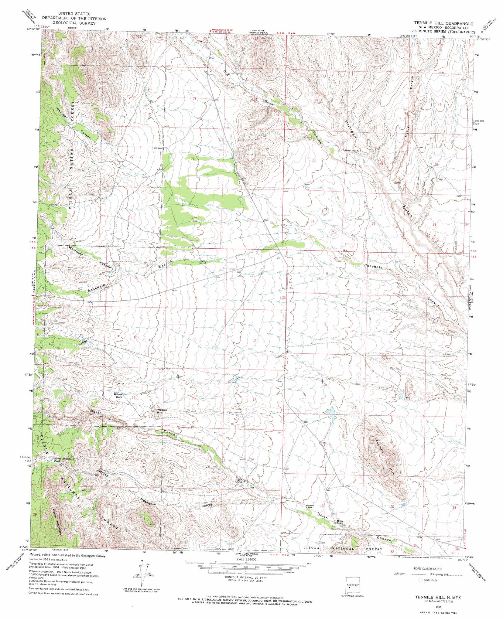
USGS Topo Quad 33107g3 - 1:24,000 scale
| Topo Map Name: | Tenmile Hill |
| USGS Topo Quad ID: | 33107g3 |
| Print Size: | ca. 21 1/4" wide x 27" high |
| Southeast Coordinates: | 33.75° N latitude / 107.25° W longitude |
| Map Center Coordinates: | 33.8125° N latitude / 107.3125° W longitude |
| U.S. State: | NM |
| Filename: | o33107g3.jpg |
| Download Map JPG Image: | Tenmile Hill topo map 1:24,000 scale |
| Map Type: | Topographic |
| Topo Series: | 7.5´ |
| Map Scale: | 1:24,000 |
| Source of Map Images: | United States Geological Survey (USGS) |
| Alternate Map Versions: |
Tenmile Hill NM 1965, updated 1968 Download PDF Buy paper map Tenmile Hill NM 1995, updated 1998 Download PDF Buy paper map Tenmile Hill NM 2011 Download PDF Buy paper map Tenmile Hill NM 2013 Download PDF Buy paper map Tenmile Hill NM 2017 Download PDF Buy paper map |
| FStopo: | US Forest Service topo Tenmile Hill is available: Download FStopo PDF Download FStopo TIF |
1:24,000 Topo Quads surrounding Tenmile Hill
Arrowhead Well |
Tres Montosas |
Arroyo Landavaso |
Magdalena |
Water Canyon |
Monica Saddle |
Mount Withington |
Squaw Peak |
South Baldy |
Molino Peak |
Bay Buck Peaks |
Grassy Lookout |
Tenmile Hill |
Puertecito Gap |
Cienega Ranch |
Welty Hill |
Blue Mountain |
San Juan Peak |
Hickman Ranch |
Fort Craig |
Montoya Butte |
Vicks Peak |
Steel Hill |
Black Hill |
Paraje Well |
> Back to 33107e1 at 1:100,000 scale
> Back to 33106a1 at 1:250,000 scale
> Back to U.S. Topo Maps home
Tenmile Hill topo map: Gazetteer
Tenmile Hill: Reservoirs
Bald Tank elevation 2003m 6571′Caliche Tank elevation 1990m 6528′
Deer Tank elevation 1992m 6535′
Horse Mountain Tank elevation 1994m 6541′
Lane Tank elevation 2017m 6617′
Wilson Tank elevation 1934m 6345′
Tenmile Hill: Summits
Horse Mountain elevation 2253m 7391′Tenmile Hill elevation 1904m 6246′
Wilson Hill elevation 1958m 6423′
Tenmile Hill: Valleys
Big Rosa Canyon elevation 1784m 5853′Chavez Canyon elevation 1979m 6492′
Hardy Canyon elevation 1779m 5836′
Horse Mountain Canyon elevation 1805m 5921′
Whitecap Canyon elevation 1927m 6322′
Tenmile Hill: Wells
Little Well elevation 1797m 5895′RG 30339 Water Well elevation 1885m 6184′
Tigner Headquaters Water Well elevation 1827m 5994′
Tenmile Hill digital topo map on disk
Buy this Tenmile Hill topo map showing relief, roads, GPS coordinates and other geographical features, as a high-resolution digital map file on DVD: