Grouse Mountain Topo Map New Mexico
To zoom in, hover over the map of Grouse Mountain
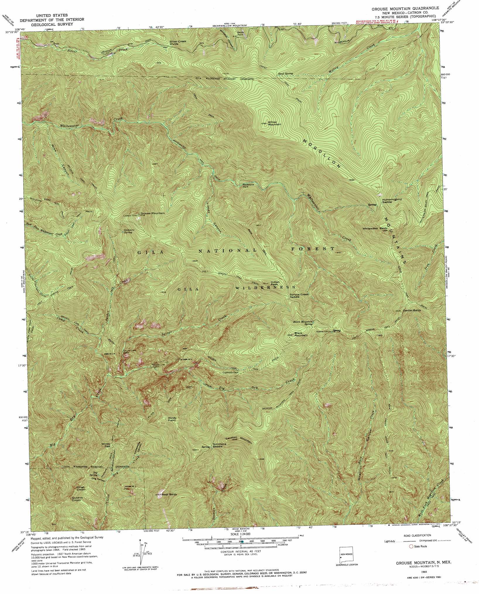
USGS Topo Quad 33108c6 - 1:24,000 scale
| Topo Map Name: | Grouse Mountain |
| USGS Topo Quad ID: | 33108c6 |
| Print Size: | ca. 21 1/4" wide x 27" high |
| Southeast Coordinates: | 33.25° N latitude / 108.625° W longitude |
| Map Center Coordinates: | 33.3125° N latitude / 108.6875° W longitude |
| U.S. State: | NM |
| Filename: | o33108c6.jpg |
| Download Map JPG Image: | Grouse Mountain topo map 1:24,000 scale |
| Map Type: | Topographic |
| Topo Series: | 7.5´ |
| Map Scale: | 1:24,000 |
| Source of Map Images: | United States Geological Survey (USGS) |
| Alternate Map Versions: |
Grouse Mountain NM 1965, updated 1970 Download PDF Buy paper map Grouse Mountain NM 1999, updated 2002 Download PDF Buy paper map Grouse Mountain NM 2011 Download PDF Buy paper map Grouse Mountain NM 2013 Download PDF Buy paper map Grouse Mountain NM 2017 Download PDF Buy paper map |
| FStopo: | US Forest Service topo Grouse Mountain is available: Download FStopo PDF Download FStopo TIF |
1:24,000 Topo Quads surrounding Grouse Mountain
Saliz Pass |
O Block Canyon |
Sign Camp Mountain |
Telephone Canyon |
Pitchfork Canyon |
Alma |
Mogollon |
Bearwallow Mountain |
Negrito Mountain |
Loco Mountain |
Glenwood |
Holt Mountain |
Grouse Mountain |
Mogollon Baldy Peak |
Lilley Mountain |
Wilson Mountain |
Moon Ranch |
Rice Ranch |
Shelley Peak |
Diablo Range |
Mule Creek |
Bear Mountain |
Buckhorn |
Canteen Canyon |
Canyon Hill |
> Back to 33108a1 at 1:100,000 scale
> Back to 33108a1 at 1:250,000 scale
> Back to U.S. Topo Maps home
Grouse Mountain topo map: Gazetteer
Grouse Mountain: Capes
Sandy Point elevation 2769m 9084′Grouse Mountain: Flats
California Park elevation 2830m 9284′Redstone Park elevation 2416m 7926′
Grouse Mountain: Gaps
Camp Creek Saddle elevation 2653m 8704′Hummingbird Saddle elevation 3164m 10380′
Silver Creek Divide elevation 2774m 9101′
Simmons Saddle elevation 3037m 9963′
Spider Saddle elevation 2825m 9268′
Spruce Creek Saddle elevation 2842m 9324′
Windy Gap elevation 2509m 8231′
Grouse Mountain: Mines
Deer Trail Tunnel elevation 2433m 7982′Deloche Trail Prospects elevation 2705m 8874′
Gold Bar elevation 2516m 8254′
Kirkpatrick Prospect elevation 2774m 9101′
Maverick Prospect elevation 2196m 7204′
Mountain View Claim elevation 2066m 6778′
New Eureka Adit elevation 2452m 8044′
Pilgrim Camp Prospects elevation 2433m 7982′
Quartz Number One Prospect elevation 2095m 6873′
Quartz Number Prospect elevation 2158m 7080′
Rainstorm Gulch Working elevation 2362m 7749′
Regal Adit elevation 2333m 7654′
Royal Gorge Claim elevation 2244m 7362′
Spruce Creek Workings elevation 2849m 9347′
Uncle John Mine elevation 2340m 7677′
Upper Big Dry Creek Prospects elevation 2698m 8851′
Upper Little Dry Creek Working elevation 2362m 7749′
Western Big Dry Creek Property elevation 2408m 7900′
Grouse Mountain: Springs
Apache Spring elevation 3116m 10223′Bead Spring elevation 3001m 9845′
Black Mountain Spring elevation 3142m 10308′
Cold Spring elevation 2762m 9061′
Dog Spring elevation 2400m 7874′
Hobo Spring elevation 2639m 8658′
Hummingbird Spring elevation 3124m 10249′
Nabours Spring elevation 2776m 9107′
Rock Spring elevation 2598m 8523′
Grouse Mountain: Streams
Camp Creek elevation 2133m 6998′Spider Creek elevation 2027m 6650′
Spruce Creek elevation 2050m 6725′
Grouse Mountain: Summits
Black Mountain elevation 3239m 10626′Center Baldy elevation 3209m 10528′
Grouse Mountain elevation 3076m 10091′
Indian Peak elevation 3062m 10045′
Kings Crown elevation 2553m 8375′
Queens Crown elevation 2558m 8392′
Sacaton Mountain elevation 3249m 10659′
West Baldy elevation 2980m 9776′
Whitewater Baldy elevation 3307m 10849′
Willow Mountain elevation 3284m 10774′
Windy Point elevation 2992m 9816′
Grouse Mountain: Trails
East Fork Trail elevation 2707m 8881′Golden Link Trail elevation 2968m 9737′
Hanging Rock Trail elevation 2475m 8120′
Rain Creek Divide Trail elevation 2786m 9140′
Sacaton Mountain Trail elevation 2947m 9668′
Silver Drip Trail elevation 2740m 8989′
Skeleton Ridge Trail elevation 2799m 9183′
Grouse Mountain: Valleys
Dog Canyon elevation 2255m 7398′Lipsey Canyon elevation 2324m 7624′
Packsaddle Canyon elevation 2372m 7782′
Rainstorm Canyon elevation 2276m 7467′
Winn Canyon elevation 2054m 6738′
Grouse Mountain digital topo map on disk
Buy this Grouse Mountain topo map showing relief, roads, GPS coordinates and other geographical features, as a high-resolution digital map file on DVD: