Holt Mountain Topo Map New Mexico
To zoom in, hover over the map of Holt Mountain
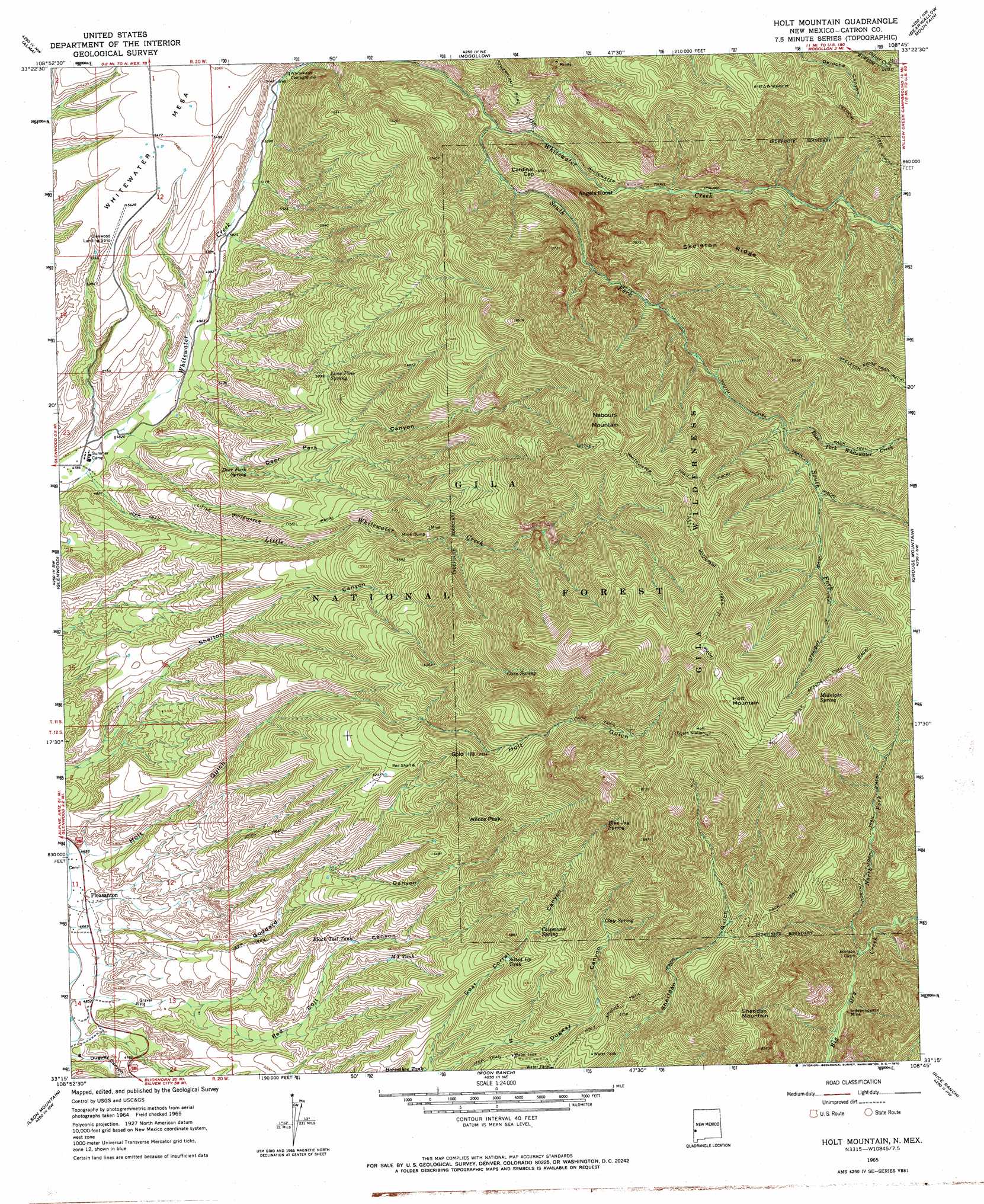
USGS Topo Quad 33108c7 - 1:24,000 scale
| Topo Map Name: | Holt Mountain |
| USGS Topo Quad ID: | 33108c7 |
| Print Size: | ca. 21 1/4" wide x 27" high |
| Southeast Coordinates: | 33.25° N latitude / 108.75° W longitude |
| Map Center Coordinates: | 33.3125° N latitude / 108.8125° W longitude |
| U.S. State: | NM |
| Filename: | o33108c7.jpg |
| Download Map JPG Image: | Holt Mountain topo map 1:24,000 scale |
| Map Type: | Topographic |
| Topo Series: | 7.5´ |
| Map Scale: | 1:24,000 |
| Source of Map Images: | United States Geological Survey (USGS) |
| Alternate Map Versions: |
Holt Mountain NM 1965, updated 1969 Download PDF Buy paper map Holt Mountain NM 1965, updated 1970 Download PDF Buy paper map Holt Mountain NM 1999, updated 2002 Download PDF Buy paper map Holt Mountain NM 2011 Download PDF Buy paper map Holt Mountain NM 2013 Download PDF Buy paper map Holt Mountain NM 2017 Download PDF Buy paper map |
| FStopo: | US Forest Service topo Holt Mountain is available: Download FStopo PDF Download FStopo TIF |
1:24,000 Topo Quads surrounding Holt Mountain
Blue |
Saliz Pass |
O Block Canyon |
Sign Camp Mountain |
Telephone Canyon |
Alma Mesa |
Alma |
Mogollon |
Bearwallow Mountain |
Negrito Mountain |
Maple Peak |
Glenwood |
Holt Mountain |
Grouse Mountain |
Mogollon Baldy Peak |
Harden Cienega |
Wilson Mountain |
Moon Ranch |
Rice Ranch |
Shelley Peak |
Big Lue Mountains |
Mule Creek |
Bear Mountain |
Buckhorn |
Canteen Canyon |
> Back to 33108a1 at 1:100,000 scale
> Back to 33108a1 at 1:250,000 scale
> Back to U.S. Topo Maps home
Holt Mountain topo map: Gazetteer
Holt Mountain: Airports
Glenwood Airport elevation 1652m 5419′Glenwood Landing Strip elevation 1651m 5416′
Whitewater Mesa Ranch Airport elevation 1672m 5485′
Holt Mountain: Benches
Whitewater Mesa elevation 1671m 5482′Holt Mountain: Flats
Tennessee Meadow elevation 2558m 8392′Holt Mountain: Forests
Glenwood Ranger District elevation 1586m 5203′Holt Mountain: Mines
Deer Park Canyon Prospects elevation 1887m 6190′Goat Corral Canyon Prospect elevation 2139m 7017′
Goddard Canyon Prospects elevation 1736m 5695′
Hardscrabble Prospects elevation 2368m 7769′
Holt Canyon Prospects elevation 2804m 9199′
Holt Tunnel elevation 2488m 8162′
Huckleberry Spar Mine elevation 1950m 6397′
Ida Bell and Bessie Number One Prospect elevation 2263m 7424′
Independence Mine elevation 1832m 6010′
Iron Bar Prospect elevation 2243m 7358′
Iron Clad Claims elevation 2488m 8162′
Iron Group Mine elevation 2225m 7299′
Kordic Claim elevation 2260m 7414′
Lauderbaugh Prospect elevation 2182m 7158′
Liberty Bell Number One Claim elevation 1840m 6036′
Little Spar Prospects elevation 2669m 8756′
Lone Star Group Mine elevation 2318m 7604′
Lone Star Number Seven Prospect elevation 2786m 9140′
Moose Group Mine elevation 1887m 6190′
Morning Star Prospects elevation 2318m 7604′
Old Uncle John Mine elevation 2368m 7769′
Red Colt Canyon Prospects elevation 1839m 6033′
Red Shaft elevation 1904m 6246′
Red Shaft Propsect elevation 1915m 6282′
Shelton Canyon Prospects elevation 1856m 6089′
The Lime Kiln Mine elevation 2225m 7299′
Thunderhead Workings elevation 2402m 7880′
Wilcox Claims elevation 2318m 7604′
Wilcox Peak Prospects elevation 2318m 7604′
Wilcox Prospects elevation 2114m 6935′
Holt Mountain: Parks
The Catwalk Historical Marker elevation 1580m 5183′Holt Mountain: Populated Places
Pleasanton elevation 1416m 4645′Wilcox Peak elevation 2116m 6942′
Holt Mountain: Post Offices
Pleasanton Post Office (historical) elevation 1416m 4645′Holt Mountain: Reservoirs
Allotment Tank elevation 1627m 5337′Black Tail Tank elevation 1678m 5505′
Cave Tank elevation 2112m 6929′
CCC Tank elevation 1578m 5177′
Fence Tank elevation 1610m 5282′
Goat Water Tank elevation 1755m 5757′
Goodard Tank elevation 1703m 5587′
Hunter Water Tank elevation 1820m 5971′
Hunters Tank elevation 2075m 6807′
Lower Tank elevation 1497m 4911′
M T Tank elevation 1708m 5603′
Middle Tank elevation 1673m 5488′
Muddy Tank elevation 1511m 4957′
PDQ Tank elevation 1597m 5239′
Red Tank elevation 1910m 6266′
Sheridan Tank elevation 1951m 6400′
Silted Up Tank elevation 1904m 6246′
Sunshine Tank elevation 1933m 6341′
West Side Tank elevation 1671m 5482′
White Water Mesa Tank elevation 1618m 5308′
York Tank elevation 1573m 5160′
Holt Mountain: Ridges
Skeleton Ridge elevation 2506m 8221′Holt Mountain: Springs
Blue Jay Spring elevation 2380m 7808′Burns Spring elevation 1906m 6253′
Cave Spring elevation 2374m 7788′
Chipmunk Spring elevation 1984m 6509′
Clay Spring elevation 2171m 7122′
Deer Park Spring elevation 1617m 5305′
Dripping Gold Spring elevation 1955m 6414′
Goat Spring elevation 1928m 6325′
Goat Spring elevation 1821m 5974′
Holt Spring elevation 2558m 8392′
Lone Pine Spring elevation 1806m 5925′
Lower Seridan Spring elevation 1866m 6122′
Lucky Tank elevation 1904m 6246′
Midnight Spring elevation 2732m 8963′
Whitetail Spring elevation 2136m 7007′
Holt Mountain: Streams
East Fork Whitewater Creek elevation 2238m 7342′Little Whitewater Creek elevation 1455m 4773′
North Fork Dry Creek elevation 1819m 5967′
South Fork Whitewater Creek elevation 1738m 5702′
Holt Mountain: Summits
Angels Roost elevation 2070m 6791′Cardinal Gap elevation 1993m 6538′
Gold Hill elevation 2111m 6925′
Holt Mountain elevation 2981m 9780′
Nabours Mountain elevation 2802m 9192′
Sheridan Mountain elevation 2528m 8293′
Holt Mountain: Trails
Deloche Trail elevation 2365m 7759′Holt Apache Trail elevation 2740m 8989′
Holt Mountain Trail elevation 2787m 9143′
Little Whitewater Trail elevation 1768m 5800′
North Fork Trail elevation 2044m 6706′
South Fork Trail elevation 2194m 7198′
Straight Up Trail elevation 2464m 8083′
Whitewater Trail elevation 1855m 6085′
Holt Mountain: Valleys
Deer Park Canyon elevation 1456m 4776′Holt Mountain: Wells
Red Colt Canyon Well elevation 1480m 4855′Schoolhouse Canyon Well elevation 1477m 4845′
Holt Mountain digital topo map on disk
Buy this Holt Mountain topo map showing relief, roads, GPS coordinates and other geographical features, as a high-resolution digital map file on DVD: