Collins Park Topo Map New Mexico
To zoom in, hover over the map of Collins Park
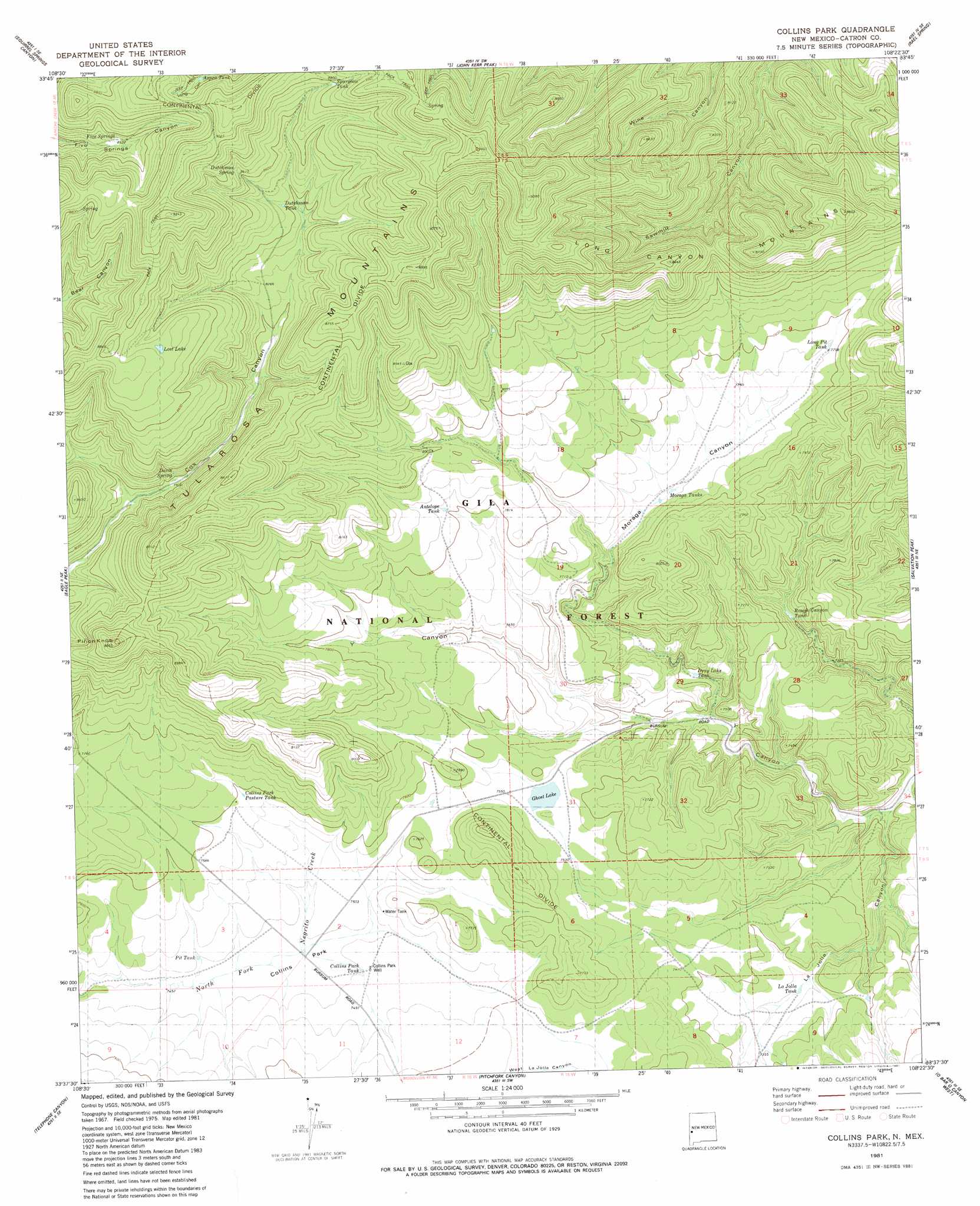
USGS Topo Quad 33108f4 - 1:24,000 scale
| Topo Map Name: | Collins Park |
| USGS Topo Quad ID: | 33108f4 |
| Print Size: | ca. 21 1/4" wide x 27" high |
| Southeast Coordinates: | 33.625° N latitude / 108.375° W longitude |
| Map Center Coordinates: | 33.6875° N latitude / 108.4375° W longitude |
| U.S. State: | NM |
| Filename: | o33108f4.jpg |
| Download Map JPG Image: | Collins Park topo map 1:24,000 scale |
| Map Type: | Topographic |
| Topo Series: | 7.5´ |
| Map Scale: | 1:24,000 |
| Source of Map Images: | United States Geological Survey (USGS) |
| Alternate Map Versions: |
Collins Park NM 1981, updated 1981 Download PDF Buy paper map Collins Parks NM 1999, updated 2002 Download PDF Buy paper map Collins Park NM 2011 Download PDF Buy paper map Collins Park NM 2013 Download PDF Buy paper map Collins Park NM 2017 Download PDF Buy paper map |
| FStopo: | US Forest Service topo Collins Park is available: Download FStopo PDF Download FStopo TIF |
1:24,000 Topo Quads surrounding Collins Park
Queens Head |
Aragon |
Tullarosa Canyon |
Bell Peak |
Horse Mountain West |
Cruzville |
Squirrel Springs Canyon |
John Kerr Peak |
Rael Spring |
Fullerton |
Milligan Mountain |
Eagle Peak |
Collins Park |
Salvation Peak |
Rail Canyon |
Sign Camp Mountain |
Telephone Canyon |
Pitchfork Canyon |
O Bar O Canyon West |
O Bar O Canyon East |
Bearwallow Mountain |
Negrito Mountain |
Loco Mountain |
Canyon Creek Mountains |
Black Mountain |
> Back to 33108e1 at 1:100,000 scale
> Back to 33108a1 at 1:250,000 scale
> Back to U.S. Topo Maps home
Collins Park topo map: Gazetteer
Collins Park: Lakes
Ghost Lake elevation 2302m 7552′Lost Lake elevation 2644m 8674′
Collins Park: Reservoirs
Antelope Tank elevation 2384m 7821′Aspen Tank elevation 2667m 8750′
Collins Park Pasture Tank elevation 2315m 7595′
Collins Park Tank elevation 2281m 7483′
Coyote Seep Tank elevation 2481m 8139′
Dray Lake Tank elevation 2247m 7372′
Dutchman Tank elevation 2572m 8438′
Fence Line Tank elevation 2289m 7509′
LaJolla Tank elevation 2231m 7319′
Long Pit Tank elevation 2366m 7762′
Moraga Tanks elevation 2340m 7677′
Park Tank elevation 2380m 7808′
Pinon Tank elevation 2419m 7936′
Pit Tank elevation 2280m 7480′
Rough Canyon Tank elevation 2263m 7424′
Salt Lick Tank elevation 2440m 8005′
Section Ten Tank elevation 2250m 7381′
Sheep Camp Tank elevation 2329m 7641′
Spurgeon Tank elevation 2679m 8789′
Collins Park: Springs
Davis Spring elevation 2503m 8211′Dutchman Spring elevation 2644m 8674′
Five Springs elevation 2600m 8530′
Collins Park: Summits
Long Canyon Mountains elevation 2649m 8690′Pinon Knob elevation 2638m 8654′
Collins Park: Valleys
East LaJolla Canyon elevation 2240m 7349′LaJolla Canyon elevation 2181m 7155′
Moraga Canyon elevation 2244m 7362′
West LaJolla Canyon elevation 2240m 7349′
Collins Park: Wells
Collins Park Well elevation 2281m 7483′Collins Park digital topo map on disk
Buy this Collins Park topo map showing relief, roads, GPS coordinates and other geographical features, as a high-resolution digital map file on DVD: