Eagle Peak Topo Map New Mexico
To zoom in, hover over the map of Eagle Peak
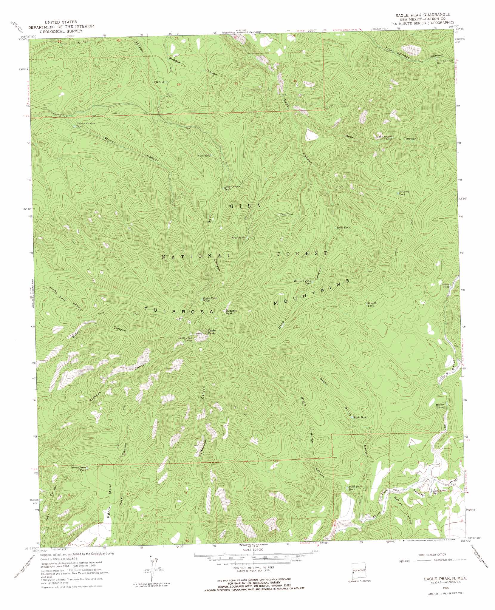
USGS Topo Quad 33108f5 - 1:24,000 scale
| Topo Map Name: | Eagle Peak |
| USGS Topo Quad ID: | 33108f5 |
| Print Size: | ca. 21 1/4" wide x 27" high |
| Southeast Coordinates: | 33.625° N latitude / 108.5° W longitude |
| Map Center Coordinates: | 33.6875° N latitude / 108.5625° W longitude |
| U.S. State: | NM |
| Filename: | o33108f5.jpg |
| Download Map JPG Image: | Eagle Peak topo map 1:24,000 scale |
| Map Type: | Topographic |
| Topo Series: | 7.5´ |
| Map Scale: | 1:24,000 |
| Source of Map Images: | United States Geological Survey (USGS) |
| Alternate Map Versions: |
Eagle Peak NM 1965, updated 1968 Download PDF Buy paper map Eagle Peak NM 1999, updated 2002 Download PDF Buy paper map Eagle Peak NM 2011 Download PDF Buy paper map Eagle Peak NM 2013 Download PDF Buy paper map Eagle Peak NM 2017 Download PDF Buy paper map |
| FStopo: | US Forest Service topo Eagle Peak is available: Download FStopo PDF Download FStopo TIF |
1:24,000 Topo Quads surrounding Eagle Peak
Centerfire Bog |
Queens Head |
Aragon |
Tullarosa Canyon |
Bell Peak |
Dillon Mountain |
Cruzville |
Squirrel Springs Canyon |
John Kerr Peak |
Rael Spring |
Reserve |
Milligan Mountain |
Eagle Peak |
Collins Park |
Salvation Peak |
O Block Canyon |
Sign Camp Mountain |
Telephone Canyon |
Pitchfork Canyon |
O Bar O Canyon West |
Mogollon |
Bearwallow Mountain |
Negrito Mountain |
Loco Mountain |
Canyon Creek Mountains |
> Back to 33108e1 at 1:100,000 scale
> Back to 33108a1 at 1:250,000 scale
> Back to U.S. Topo Maps home
Eagle Peak topo map: Gazetteer
Eagle Peak: Benches
Perry Mesa elevation 2259m 7411′Eagle Peak: Forests
Reserve Ranger District elevation 2511m 8238′Eagle Peak: Reservoirs
Bear Canyon Tank elevation 2429m 7969′Black Burro Tank elevation 2274m 7460′
Buzzard Peak Tank elevation 2472m 8110′
Deep Tank elevation 2434m 7985′
Eagle Peak Tank elevation 2727m 8946′
End of Road Tank elevation 2431m 7975′
FD Tank elevation 2268m 7440′
Five Springs Tank elevation 2521m 8270′
Fork Tank elevation 2381m 7811′
Long Canyon Tank elevation 2428m 7965′
McCarty Tank elevation 2541m 8336′
Miner Tank elevation 2391m 7844′
Negrito Tank elevation 2202m 7224′
Perry Canyon Tank elevation 2295m 7529′
Perry Mesa Tank elevation 2254m 7395′
Road Tank elevation 2555m 8382′
Rock Tank elevation 2349m 7706′
Sheep Seep Tank elevation 2438m 7998′
Trial Tank elevation 2413m 7916′
Trujillo Tank elevation 2487m 8159′
Wilson Canyon Tank elevation 2214m 7263′
Eagle Peak: Springs
Deadman Spring elevation 2253m 7391′Eagle Peak Spring elevation 2875m 9432′
Hidden Spring elevation 2335m 7660′
Eagle Peak: Summits
Buzzard Peak elevation 2948m 9671′Eagle Peak elevation 2970m 9744′
Eagle Peak: Valleys
Barrel Canyon elevation 2232m 7322′Bear Canyon elevation 2258m 7408′
Black Burro Canyon elevation 2217m 7273′
Black Horse Canyon elevation 2192m 7191′
Cox Canyon elevation 2239m 7345′
Eagle Peak digital topo map on disk
Buy this Eagle Peak topo map showing relief, roads, GPS coordinates and other geographical features, as a high-resolution digital map file on DVD: