Reserve Topo Map New Mexico
To zoom in, hover over the map of Reserve
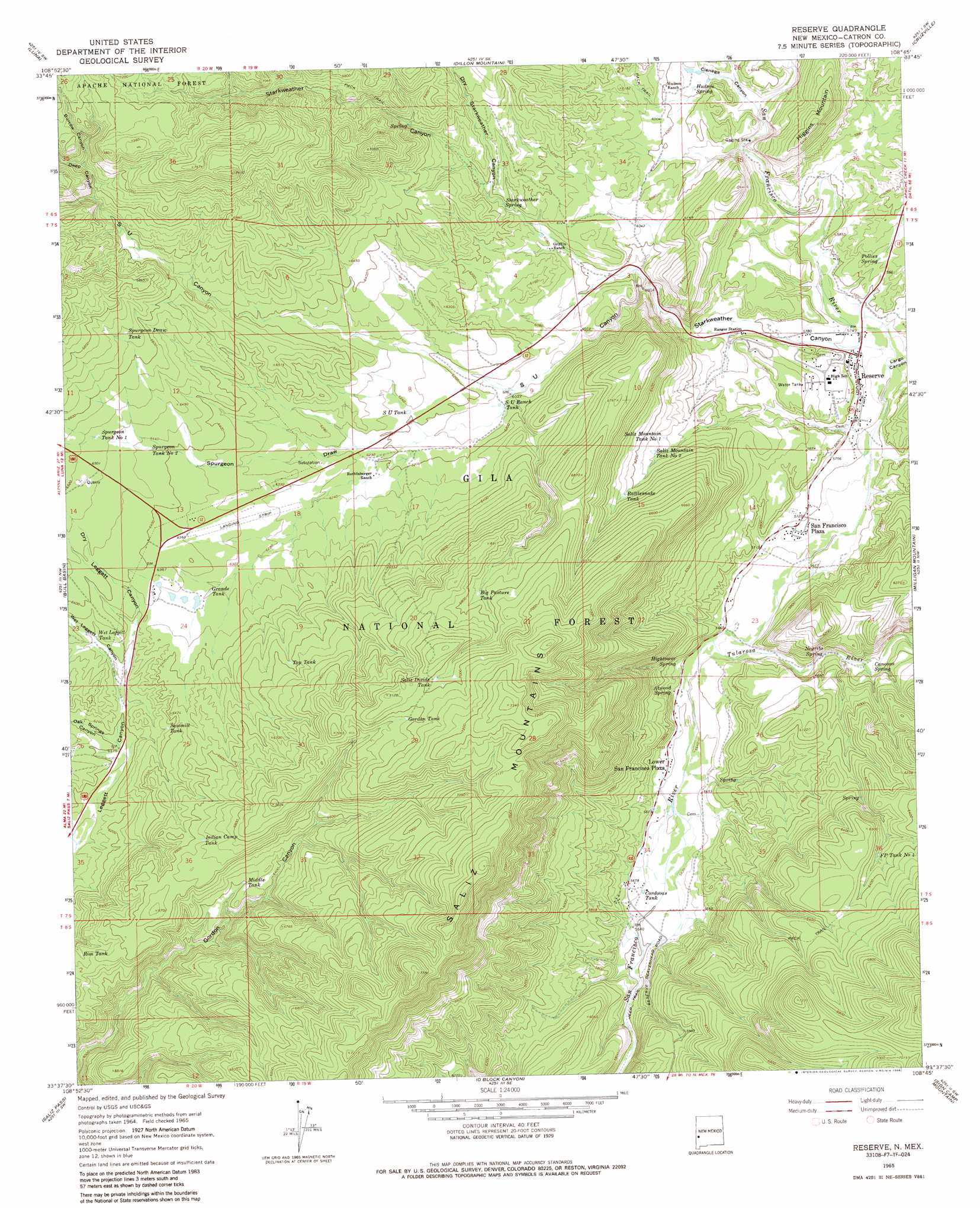
USGS Topo Quad 33108f7 - 1:24,000 scale
| Topo Map Name: | Reserve |
| USGS Topo Quad ID: | 33108f7 |
| Print Size: | ca. 21 1/4" wide x 27" high |
| Southeast Coordinates: | 33.625° N latitude / 108.75° W longitude |
| Map Center Coordinates: | 33.6875° N latitude / 108.8125° W longitude |
| U.S. State: | NM |
| Filename: | o33108f7.jpg |
| Download Map JPG Image: | Reserve topo map 1:24,000 scale |
| Map Type: | Topographic |
| Topo Series: | 7.5´ |
| Map Scale: | 1:24,000 |
| Source of Map Images: | United States Geological Survey (USGS) |
| Alternate Map Versions: |
Reserve NM 1965, updated 1968 Download PDF Buy paper map Reserve NM 1965, updated 1986 Download PDF Buy paper map Reserve NM 1999, updated 2002 Download PDF Buy paper map Reserve NM 2011 Download PDF Buy paper map Reserve NM 2013 Download PDF Buy paper map Reserve NM 2017 Download PDF Buy paper map |
| FStopo: | US Forest Service topo Reserve is available: Download FStopo PDF Download FStopo TIF |
1:24,000 Topo Quads surrounding Reserve
Escudilla Mountain |
Underwood Lake |
Centerfire Bog |
Queens Head |
Aragon |
Luna Lake |
Luna |
Dillon Mountain |
Cruzville |
Squirrel Springs Canyon |
Maness Peak |
Bull Basin |
Reserve |
Milligan Mountain |
Eagle Peak |
Blue |
Saliz Pass |
O Block Canyon |
Sign Camp Mountain |
Telephone Canyon |
Alma Mesa |
Alma |
Mogollon |
Bearwallow Mountain |
Negrito Mountain |
> Back to 33108e1 at 1:100,000 scale
> Back to 33108a1 at 1:250,000 scale
> Back to U.S. Topo Maps home
Reserve topo map: Gazetteer
Reserve: Airports
Reserve Airport elevation 1929m 6328′Reserve: Mines
S.U. Canyon Sand and Gravel Prospect elevation 1940m 6364′Reserve: Populated Places
Lower San Francisco Plaza elevation 1724m 5656′Rancho Grande Estates elevation 1940m 6364′
Reserve elevation 1759m 5770′
San Francisco Plaza elevation 1745m 5725′
Reserve: Post Offices
Reserve Post Office elevation 1759m 5770′Reserve: Reservoirs
Balkie Tank elevation 1946m 6384′Big Pasture Tank elevation 2053m 6735′
Cordovas Tank elevation 1718m 5636′
FP Tank Number 4 elevation 1915m 6282′
Gordon Tank elevation 2121m 6958′
Grande Tank elevation 1927m 6322′
Indian Camp Tank elevation 2023m 6637′
Lower Plaza Tank Number One elevation 1844m 6049′
Lower Plaza Tank Number Two elevation 2182m 7158′
Middle Tank elevation 1952m 6404′
Rattlesnake Tank elevation 1903m 6243′
Red Tank elevation 2110m 6922′
Rim Tank elevation 1976m 6482′
S U Ranch Tank elevation 1870m 6135′
S U Tank elevation 1896m 6220′
S U Tank Number Two elevation 1857m 6092′
Saddle Tank elevation 2050m 6725′
Saliz Divide Tank elevation 2122m 6961′
Saliz Mountain Tank Number 1 elevation 1852m 6076′
Saliz Mountain Tank Number 2 elevation 1864m 6115′
Sawmill Tank elevation 1937m 6354′
Spring Tank elevation 1999m 6558′
Spurgeon Draw Tank elevation 2035m 6676′
Spurgeon Draw Tanks elevation 2035m 6676′
Spurgeon Tank Number 1 elevation 1984m 6509′
Spurgeon Tank Number 2 elevation 1960m 6430′
Stone Tank elevation 2154m 7066′
Top Tank elevation 2005m 6578′
Wee Tank elevation 1995m 6545′
Wet Leggett Tank elevation 1923m 6309′
Reserve: Springs
Atwood Spring elevation 1739m 5705′Canovas Spring elevation 1738m 5702′
Frisco Spring elevation 1734m 5688′
Griffen Spring elevation 1849m 6066′
Hightower Spring elevation 1739m 5705′
Hudson Spring elevation 1813m 5948′
Negrito Spring elevation 1745m 5725′
Pollies Spring elevation 1798m 5898′
S U Spring elevation 1876m 6154′
Starkweather Spring elevation 1877m 6158′
Reserve: Streams
Tularosa River elevation 1722m 5649′Reserve: Summits
Higgins Mountain elevation 1977m 6486′Reserve: Valleys
Burrow Canyon elevation 2091m 6860′Cienega Canyon elevation 1780m 5839′
Deep Canyon elevation 2048m 6719′
Dry Leggett Canyon elevation 1926m 6318′
Dry Starkweather Canyon elevation 1876m 6154′
Largo Canyon elevation 1748m 5734′
Magdalena Canyon elevation 1740m 5708′
Oak Springs Canyon elevation 1887m 6190′
S U Canyon elevation 1816m 5958′
Spurgeon Draw elevation 1863m 6112′
Starkweather Canyon elevation 1749m 5738′
Wet Leggett Canyon elevation 1896m 6220′
Reserve: Wells
10008 Water Well elevation 1938m 6358′Reserve digital topo map on disk
Buy this Reserve topo map showing relief, roads, GPS coordinates and other geographical features, as a high-resolution digital map file on DVD: