Dillon Mountain Topo Map New Mexico
To zoom in, hover over the map of Dillon Mountain
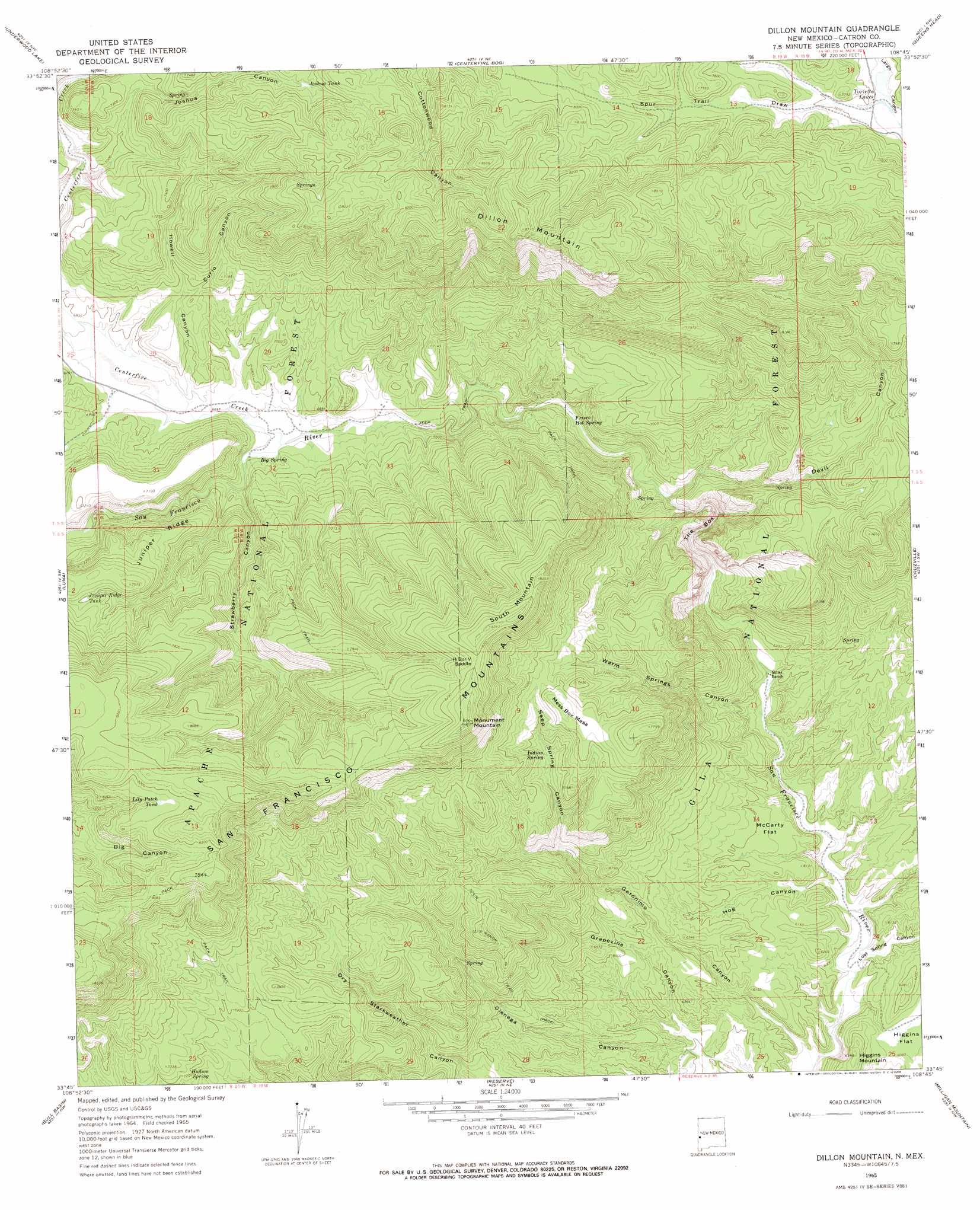
USGS Topo Quad 33108g7 - 1:24,000 scale
| Topo Map Name: | Dillon Mountain |
| USGS Topo Quad ID: | 33108g7 |
| Print Size: | ca. 21 1/4" wide x 27" high |
| Southeast Coordinates: | 33.75° N latitude / 108.75° W longitude |
| Map Center Coordinates: | 33.8125° N latitude / 108.8125° W longitude |
| U.S. State: | NM |
| Filename: | o33108g7.jpg |
| Download Map JPG Image: | Dillon Mountain topo map 1:24,000 scale |
| Map Type: | Topographic |
| Topo Series: | 7.5´ |
| Map Scale: | 1:24,000 |
| Source of Map Images: | United States Geological Survey (USGS) |
| Alternate Map Versions: |
Dillon Mountain NM 1965, updated 1969 Download PDF Buy paper map Dillon Mountain NM 1999, updated 2002 Download PDF Buy paper map Dillon Mountain NM 2011 Download PDF Buy paper map Dillon Mountain NM 2013 Download PDF Buy paper map Dillon Mountain NM 2017 Download PDF Buy paper map |
| FStopo: | US Forest Service topo Dillon Mountain is available: Download FStopo PDF Download FStopo TIF |
1:24,000 Topo Quads surrounding Dillon Mountain
Loco Knoll |
Jones Canyon |
Black Peak |
Gallo Mountains West |
Gallo Mountains East |
Escudilla Mountain |
Underwood Lake |
Centerfire Bog |
Queens Head |
Aragon |
Luna Lake |
Luna |
Dillon Mountain |
Cruzville |
Squirrel Springs Canyon |
Maness Peak |
Bull Basin |
Reserve |
Milligan Mountain |
Eagle Peak |
Blue |
Saliz Pass |
O Block Canyon |
Sign Camp Mountain |
Telephone Canyon |
> Back to 33108e1 at 1:100,000 scale
> Back to 33108a1 at 1:250,000 scale
> Back to U.S. Topo Maps home
Dillon Mountain topo map: Gazetteer
Dillon Mountain: Flats
McCarty Flat elevation 1877m 6158′Dillon Mountain: Gaps
H Bar V Saddle elevation 2492m 8175′Dillon Mountain: Reservoirs
Crass V Tank elevation 2169m 7116′Curio Tank elevation 2168m 7112′
Devil Tank elevation 2164m 7099′
Devil Tank Number One elevation 2307m 7568′
Devil Tank Number Two elevation 2351m 7713′
Heifer Basin Tank elevation 2165m 7103′
Howell Tank elevation 2230m 7316′
Joshua Tank elevation 2285m 7496′
Juniper Ridge Tank elevation 2254m 7395′
Liedman Tank elevation 2447m 8028′
Lily Patch Tank elevation 2482m 8143′
Lonnie Tank elevation 2477m 8126′
Pine Tank elevation 1944m 6377′
Shelby Tank elevation 2438m 7998′
Strawberry Tank elevation 2247m 7372′
Toriette Lakes elevation 2300m 7545′
Dillon Mountain: Ridges
Juniper Ridge elevation 2232m 7322′South Mountain elevation 2539m 8330′
Dillon Mountain: Springs
Big Spring elevation 2040m 6692′Bill Lewis Spring elevation 1878m 6161′
Devil Spring elevation 2069m 6788′
Frisco Hot Spring elevation 1983m 6505′
Hudson Spring elevation 2165m 7103′
Indian Spring elevation 2159m 7083′
Lion Spring elevation 2059m 6755′
Mess Box Spring elevation 1879m 6164′
Skunk Spring elevation 2104m 6902′
Upper Frisco Hot Springs elevation 2035m 6676′
Dillon Mountain: Streams
Centerfire Creek elevation 2030m 6660′Dillon Mountain: Summits
Bill Lewis Mesa elevation 2213m 7260′Dillon Mountain elevation 2650m 8694′
Mess Box Mesa elevation 2360m 7742′
Monument Mountain elevation 2540m 8333′
Dillon Mountain: Valleys
Curio Canyon elevation 2111m 6925′Devil Canyon elevation 1963m 6440′
Geronimo Canyon elevation 1788m 5866′
Grapevine Canyon elevation 1824m 5984′
Hog Canyon elevation 1816m 5958′
Howell Canyon elevation 2043m 6702′
Joshua Canyon elevation 2085m 6840′
Lost Spring Canyon elevation 1801m 5908′
Pine Canyon elevation 1854m 6082′
Seep Spring Canyon elevation 2020m 6627′
Spur Trail Draw elevation 2297m 7536′
Strawberry Canyon elevation 2036m 6679′
The Box elevation 2034m 6673′
The Box elevation 1902m 6240′
Warm Springs Canyon elevation 1849m 6066′
Dillon Mountain digital topo map on disk
Buy this Dillon Mountain topo map showing relief, roads, GPS coordinates and other geographical features, as a high-resolution digital map file on DVD: