Queens Head Topo Map New Mexico
To zoom in, hover over the map of Queens Head
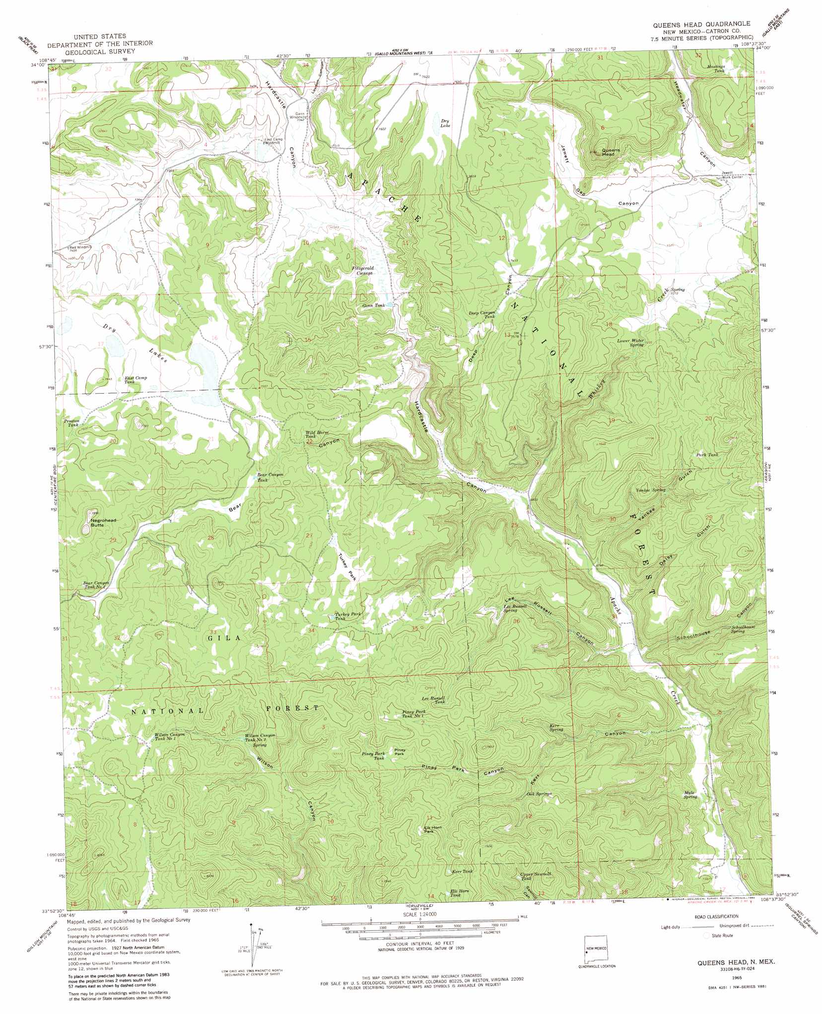
USGS Topo Quad 33108h6 - 1:24,000 scale
| Topo Map Name: | Queens Head |
| USGS Topo Quad ID: | 33108h6 |
| Print Size: | ca. 21 1/4" wide x 27" high |
| Southeast Coordinates: | 33.875° N latitude / 108.625° W longitude |
| Map Center Coordinates: | 33.9375° N latitude / 108.6875° W longitude |
| U.S. State: | NM |
| Filename: | o33108h6.jpg |
| Download Map JPG Image: | Queens Head topo map 1:24,000 scale |
| Map Type: | Topographic |
| Topo Series: | 7.5´ |
| Map Scale: | 1:24,000 |
| Source of Map Images: | United States Geological Survey (USGS) |
| Alternate Map Versions: |
Queens Head NM 1965, updated 1968 Download PDF Buy paper map Queens Head NM 1965, updated 1984 Download PDF Buy paper map Queens Head NM 1999, updated 2002 Download PDF Buy paper map Queens Head NM 2011 Download PDF Buy paper map Queens Head NM 2013 Download PDF Buy paper map Queens Head NM 2017 Download PDF Buy paper map |
| FStopo: | US Forest Service topo Queens Head is available: Download FStopo PDF Download FStopo TIF |
1:24,000 Topo Quads surrounding Queens Head
Cow Springs |
Red Hill |
Pondersoa Tank |
Largo Mesa |
Escondido Mountains |
Jones Canyon |
Black Peak |
Gallo Mountains West |
Gallo Mountains East |
Slaughter Mesa |
Underwood Lake |
Centerfire Bog |
Queens Head |
Aragon |
Tullarosa Canyon |
Luna |
Dillon Mountain |
Cruzville |
Squirrel Springs Canyon |
John Kerr Peak |
Bull Basin |
Reserve |
Milligan Mountain |
Eagle Peak |
Collins Park |
> Back to 33108e1 at 1:100,000 scale
> Back to 33108a1 at 1:250,000 scale
> Back to U.S. Topo Maps home
Queens Head topo map: Gazetteer
Queens Head: Flats
Elk Horn Park elevation 2325m 7627′Piney Park elevation 2277m 7470′
Turkey Park elevation 2268m 7440′
Queens Head: Forests
Quemado Ranger District elevation 2330m 7644′Queens Head: Lakes
Dry Lake elevation 2336m 7664′Dry Lakes elevation 2303m 7555′
Queens Head: Reservoirs
Bear Canyon Tank elevation 2286m 7500′Bear Canyon Tank Number Two elevation 2328m 7637′
Deep Canyon Tank elevation 2261m 7417′
East Camp Tank elevation 2305m 7562′
Elk Horn Tank elevation 2324m 7624′
Gann Tank elevation 2198m 7211′
Hastings Tank elevation 2349m 7706′
Kerr Tank elevation 2314m 7591′
Lee Russell Tank elevation 2292m 7519′
Park Tank elevation 2265m 7431′
Piney Park Tank elevation 2275m 7463′
Piney Park Tank Number 1 elevation 2303m 7555′
Preston Tank elevation 2303m 7555′
Turkey Park Tank elevation 2256m 7401′
Upper Sawmill Tank elevation 2307m 7568′
Wild Horse Tank elevation 2269m 7444′
Wilson Canyon Tank Number 1 elevation 2343m 7687′
Wilson Canyon Tank Number 2 elevation 2286m 7500′
Queens Head: Springs
Kerr Spring elevation 2170m 7119′Lee Russell Spring elevation 2158m 7080′
Lower Water Spring elevation 2206m 7237′
Mule Spring elevation 2034m 6673′
Oak Springs elevation 2201m 7221′
Schoolhouse Spring elevation 2141m 7024′
Yankee Spring elevation 2158m 7080′
Queens Head: Streams
Whiskey Creek elevation 2073m 6801′Queens Head: Summits
Negrohead Butte elevation 2404m 7887′Queens Head elevation 2476m 8123′
Queens Head: Swamps
Fitzgerald Cienega elevation 2201m 7221′Queens Head: Valleys
Bear Canyon elevation 2097m 6879′Daisy Gulch elevation 2050m 6725′
Deep Canyon elevation 2107m 6912′
Hardcastle Canyon elevation 2073m 6801′
Headwater Canyon elevation 2240m 7349′
Jewett Gap Canyon elevation 2229m 7312′
Kerr Canyon elevation 2021m 6630′
Lawson Canyon elevation 2240m 7349′
Lee Russell Canyon elevation 2037m 6683′
Piney Park Canyon elevation 2172m 7125′
Sawmill Canyon elevation 2002m 6568′
Schoolhouse Canyon elevation 2046m 6712′
Yankee Gulch elevation 2050m 6725′
Queens Head digital topo map on disk
Buy this Queens Head topo map showing relief, roads, GPS coordinates and other geographical features, as a high-resolution digital map file on DVD: