Centerfire Bog Topo Map New Mexico
To zoom in, hover over the map of Centerfire Bog
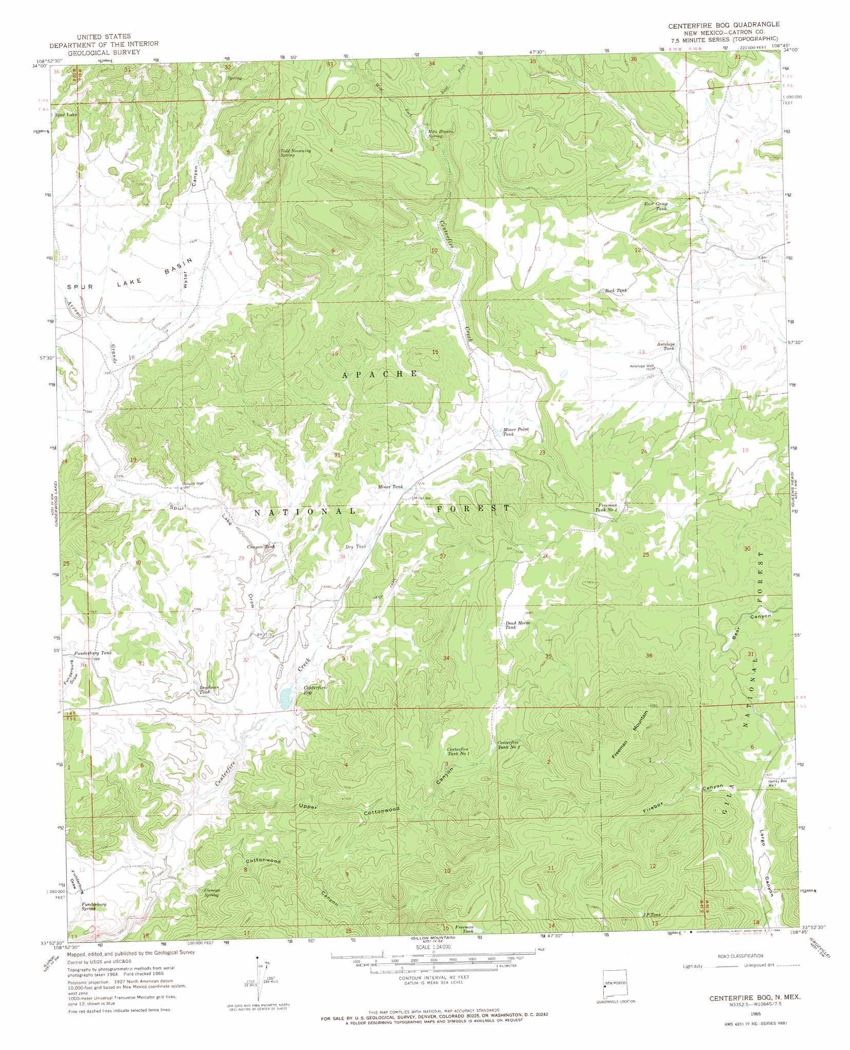
USGS Topo Quad 33108h7 - 1:24,000 scale
| Topo Map Name: | Centerfire Bog |
| USGS Topo Quad ID: | 33108h7 |
| Print Size: | ca. 21 1/4" wide x 27" high |
| Southeast Coordinates: | 33.875° N latitude / 108.75° W longitude |
| Map Center Coordinates: | 33.9375° N latitude / 108.8125° W longitude |
| U.S. State: | NM |
| Filename: | o33108h7.jpg |
| Download Map JPG Image: | Centerfire Bog topo map 1:24,000 scale |
| Map Type: | Topographic |
| Topo Series: | 7.5´ |
| Map Scale: | 1:24,000 |
| Source of Map Images: | United States Geological Survey (USGS) |
| Alternate Map Versions: |
Centerfire Bog NM 1965, updated 1968 Download PDF Buy paper map Centerfire Bog NM 1965, updated 1968 Download PDF Buy paper map Centerfire Bog NM 1999, updated 2002 Download PDF Buy paper map Centerfire Bog NM 2011 Download PDF Buy paper map Centerfire Bog NM 2013 Download PDF Buy paper map Centerfire Bog NM 2017 Download PDF Buy paper map |
| FStopo: | US Forest Service topo Centerfire Bog is available: Download FStopo PDF Download FStopo TIF |
1:24,000 Topo Quads surrounding Centerfire Bog
Nelson Reservoir Ne |
Cow Springs |
Red Hill |
Pondersoa Tank |
Largo Mesa |
Loco Knoll |
Jones Canyon |
Black Peak |
Gallo Mountains West |
Gallo Mountains East |
Escudilla Mountain |
Underwood Lake |
Centerfire Bog |
Queens Head |
Aragon |
Luna Lake |
Luna |
Dillon Mountain |
Cruzville |
Squirrel Springs Canyon |
Maness Peak |
Bull Basin |
Reserve |
Milligan Mountain |
Eagle Peak |
> Back to 33108e1 at 1:100,000 scale
> Back to 33108a1 at 1:250,000 scale
> Back to U.S. Topo Maps home
Centerfire Bog topo map: Gazetteer
Centerfire Bog: Basins
Spur Lake Basin elevation 2242m 7355′Centerfire Bog: Reservoirs
Antelope Tank elevation 2292m 7519′Black Gap Tank Number Two elevation 2196m 7204′
Cabin Tank elevation 2375m 7791′
Canyon Tank elevation 2199m 7214′
Centerfire Tank Number 1 elevation 2325m 7627′
Centerfire Tank Number 2 elevation 2340m 7677′
Corner Tank Number One elevation 2233m 7326′
Corner Tank Number Two elevation 2400m 7874′
Dead Horse Tank elevation 2339m 7673′
Deadman Tank elevation 2183m 7162′
Draw Tank elevation 2346m 7696′
Dry Tank elevation 2203m 7227′
East Camp Tank elevation 2313m 7588′
Fifteen Tank elevation 2266m 7434′
Freeman Tank elevation 2423m 7949′
Freeman Tank Number 2 elevation 2329m 7641′
Funderburg Tank elevation 2217m 7273′
Gap Tank elevation 2231m 7319′
Hay Tank elevation 2249m 7378′
J P Tank elevation 2361m 7746′
Lower Cottonwood Tank elevation 2264m 7427′
Miner Point Tank elevation 2236m 7335′
Miner Tank elevation 2218m 7276′
Nancy Tank elevation 2308m 7572′
Peak Tank elevation 2257m 7404′
Rock Tank elevation 2317m 7601′
Shack Tank elevation 2388m 7834′
Upper Cottonwood Tank elevation 2260m 7414′
Whiting Tank elevation 2206m 7237′
Centerfire Bog: Springs
Cienega Spring elevation 2160m 7086′Funderburg Spring elevation 2159m 7083′
Rita Blanca Spring elevation 2366m 7762′
Todd Browning Spring elevation 2390m 7841′
Centerfire Bog: Streams
Arroyo Grande elevation 2241m 7352′Arroyo Grande elevation 2241m 7352′
East Fork Centerfire Creek elevation 2364m 7755′
West Fork Centerfire Creek elevation 2364m 7755′
Centerfire Bog: Summits
Freeman Mountain elevation 2674m 8772′Centerfire Bog: Swamps
Centerfire Bog elevation 2180m 7152′Centerfire Bog: Valleys
Cottonwood Canyon elevation 2132m 6994′Firebox Canyon elevation 2326m 7631′
Spur Lake Draw elevation 2172m 7125′
Upper Cottonwood Canyon elevation 2146m 7040′
Water Canyon elevation 2241m 7352′
Centerfire Bog: Wells
Antelope Well elevation 2294m 7526′Canyon Well elevation 2221m 7286′
Honey Bee Well elevation 2333m 7654′
Miner Well elevation 2224m 7296′
Centerfire Bog digital topo map on disk
Buy this Centerfire Bog topo map showing relief, roads, GPS coordinates and other geographical features, as a high-resolution digital map file on DVD: