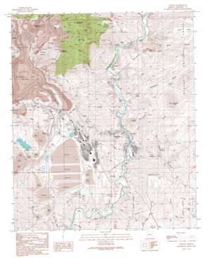
Clifton Topo Map Arizona
To zoom in, hover over the map of Clifton
USGS Topo Quad 33109a3 - 1:24,000 scale
| Topo Map Name: | Clifton |
| USGS Topo Quad ID: | 33109a3 |
| Print Size: | ca. 21 1/4" wide x 27" high |
| Southeast Coordinates: | 33° N latitude / 109.25° W longitude |
| Map Center Coordinates: | 33.0625° N latitude / 109.3125° W longitude |
| U.S. State: | AZ |
| Filename: | o33109a3.jpg |
| Download Map JPG Image: | Clifton topo map 1:24,000 scale |
| Map Type: | Topographic |
| Topo Series: | 7.5´ |
| Map Scale: | 1:24,000 |
| Source of Map Images: | United States Geological Survey (USGS) |
| Alternate Map Versions: |
Clifton AZ 1989, updated 1990 Download PDF Buy paper map Clifton AZ 1997, updated 2000 Download PDF Buy paper map Clifton AZ 2011 Download PDF Buy paper map Clifton AZ 2014 Download PDF Buy paper map |
| FStopo: | US Forest Service topo Clifton is available: Download FStopo PDF Download FStopo TIF |
1:24,000 Topo Quads surrounding Clifton
> Back to 33109a1 at 1:100,000 scale
> Back to 33108a1 at 1:250,000 scale
> Back to U.S. Topo Maps home
Clifton topo map: Gazetteer
Clifton: Cliffs
Evans Point elevation 1229m 4032′Clifton: Dams
Tailings Water Reclamation Dam elevation 1093m 3585′Clifton: Mines
Morenci Open Pit elevation 1272m 4173′Clifton: Parks
Blackbridge Picnic Area elevation 1299m 4261′Clifton: Populated Places
Clifton elevation 1060m 3477′East Plantsite elevation 1249m 4097′
Morenci elevation 1447m 4747′
Plantsite elevation 1295m 4248′
Stargo elevation 1428m 4685′
Clifton: Post Offices
Clifton Post Office elevation 1076m 3530′Morenci Post Office elevation 1243m 4078′
Clifton: Reservoirs
Tailings Water Reclamation Reservoir elevation 1260m 4133′Clifton: Springs
Ash Spring elevation 1257m 4124′Cement Spring elevation 1246m 4087′
Clifton Hot Springs elevation 1075m 3526′
Hot Spring elevation 1067m 3500′
Limestone Spring elevation 1212m 3976′
Clifton: Streams
Chase Creek elevation 1053m 3454′King Creek elevation 1378m 4520′
Silver Basin Creek elevation 1018m 3339′
Clifton: Summits
Clifton Peak elevation 1363m 4471′Copper King Mountain elevation 2075m 6807′
Harper Mesa elevation 1477m 4845′
Markeen Mountain elevation 1943m 6374′
Modoc Mountain elevation 1491m 4891′
Modoc Mountain elevation 1513m 4963′
Morenci Mountain elevation 1440m 4724′
Mulligan Peak elevation 1709m 5606′
Shannon Mountain elevation 1527m 5009′
Smelter Hill elevation 1150m 3772′
Square Butte elevation 1494m 4901′
Clifton: Valleys
Ash Spring Canyon elevation 1095m 3592′Colorado Gulch elevation 1120m 3674′
Devils Canyon elevation 1072m 3517′
Dorsey Gulch elevation 1174m 3851′
Drive Canyon elevation 1042m 3418′
Hickory Gulch elevation 1321m 4333′
King Gulch elevation 1378m 4520′
Limestone Gulch elevation 1068m 3503′
Morenci Gulch elevation 1034m 3392′
Morenci Gulch elevation 1351m 4432′
Placer Gulch elevation 1621m 5318′
Red Canyon elevation 1096m 3595′
Rock House Canyon elevation 1167m 3828′
Rocky Gulch elevation 1097m 3599′
Standard Gulch elevation 1302m 4271′
Stargo Gulch elevation 1261m 4137′
Trail Canyon elevation 1025m 3362′
Ward Canyon elevation 1049m 3441′
West Brushy Canyon elevation 1167m 3828′
Clifton digital topo map on disk
Buy this Clifton topo map showing relief, roads, GPS coordinates and other geographical features, as a high-resolution digital map file on DVD:


