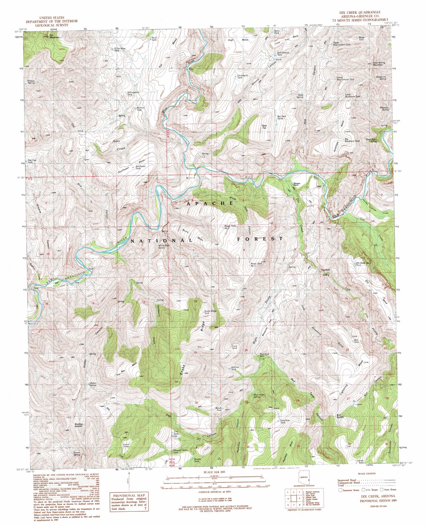
Dix Creek Topo Map Arizona
To zoom in, hover over the map of Dix Creek
USGS Topo Quad 33109b2 - 1:24,000 scale
| Topo Map Name: | Dix Creek |
| USGS Topo Quad ID: | 33109b2 |
| Print Size: | ca. 21 1/4" wide x 27" high |
| Southeast Coordinates: | 33.125° N latitude / 109.125° W longitude |
| Map Center Coordinates: | 33.1875° N latitude / 109.1875° W longitude |
| U.S. State: | AZ |
| Filename: | o33109b2.jpg |
| Download Map JPG Image: | Dix Creek topo map 1:24,000 scale |
| Map Type: | Topographic |
| Topo Series: | 7.5´ |
| Map Scale: | 1:24,000 |
| Source of Map Images: | United States Geological Survey (USGS) |
| Alternate Map Versions: |
Dix Creek AZ 1989, updated 1990 Download PDF Buy paper map Dix Creek AZ 1997, updated 2000 Download PDF Buy paper map Dix Creek AZ 2011 Download PDF Buy paper map Dix Creek AZ 2014 Download PDF Buy paper map |
| FStopo: | US Forest Service topo Dix Creek is available: Download FStopo PDF Download FStopo TIF |
1:24,000 Topo Quads surrounding Dix Creek
Robinson Mesa |
Rose Peak |
Dutch Blue Creek |
Alma Mesa |
Alma |
Bee Canyon |
Pipestem Mountain |
Fritz Canyon |
Maple Peak |
Glenwood |
Coronado Mountain |
Mitchell Peak |
Dix Creek |
Harden Cienega |
Wilson Mountain |
Copperplate Gulch |
Clifton |
Rattlesnake Spring |
Big Lue Mountains |
Mule Creek |
Gila Box |
Guthrie |
York |
Tillie Hall Peak |
Crookson Peak |
> Back to 33109a1 at 1:100,000 scale
> Back to 33108a1 at 1:250,000 scale
> Back to U.S. Topo Maps home
Dix Creek topo map: Gazetteer
Dix Creek: Flats
Mesquite Flat elevation 1400m 4593′Sunset Glade elevation 1919m 6295′
Dix Creek: Gaps
Bootleg Saddle elevation 1699m 5574′Bull Saddle elevation 1695m 5561′
Dix Creek: Reservoirs
Basin Tank elevation 1497m 4911′Beehive Tank elevation 1329m 4360′
Bench Tank elevation 1616m 5301′
Big Buckhorn Tank elevation 1619m 5311′
Big Tank Series elevation 1488m 4881′
Big Tank Series Number One elevation 1501m 4924′
Bloody Canyon Tank elevation 1568m 5144′
Bobby Tank elevation 1658m 5439′
Boulder Tank elevation 1682m 5518′
Brushy Tank elevation 1660m 5446′
Brushy Tanks Number One elevation 1785m 5856′
Bull Canyon Tank elevation 1646m 5400′
Burro Mesa Tank elevation 1572m 5157′
Chinaberry Tank elevation 1491m 4891′
Chinaberry Tank elevation 1509m 4950′
Chuck Box Tank elevation 1303m 4274′
Corner Tank elevation 1743m 5718′
Curly Tank elevation 1612m 5288′
Dix Mesa Number One Tank elevation 1629m 5344′
Dix Mesa Number Two Tank elevation 1597m 5239′
Dix Mesa Tank elevation 1632m 5354′
Draw Tank elevation 1764m 5787′
Fence Tank elevation 1851m 6072′
Hamilton Tank elevation 1686m 5531′
Johnnie Tank elevation 1443m 4734′
Lightening Mesa Tank elevation 1667m 5469′
Lightning Mesa Tank elevation 1660m 5446′
Lower Buckhorn Tank elevation 1632m 5354′
Lower Bull Tank elevation 1645m 5396′
Lower Hog Canyon Tank elevation 1567m 5141′
Mesquite Flat Tank elevation 1457m 4780′
Mesquite Tank elevation 1375m 4511′
Middle Tank elevation 1745m 5725′
North Pat Mesa Tank elevation 1439m 4721′
Number Two Tank elevation 1388m 4553′
Panther Tank elevation 1665m 5462′
Pat Mesa Tank elevation 1440m 4724′
Piñon Tank Number One elevation 1594m 5229′
Pleasant Valley Tank elevation 1668m 5472′
Pleasant Valley Tank elevation 1663m 5456′
Pleasant Valley Tank Number Two elevation 1668m 5472′
Red Flats Tank elevation 1369m 4491′
Red Tank Well elevation 1443m 4734′
Ridge Tank elevation 1765m 5790′
Salt Ground Tank elevation 1533m 5029′
Saltground Tank elevation 1649m 5410′
Snake Ridge Tank elevation 1621m 5318′
Split Ridge Tank elevation 1260m 4133′
Sunflower Mesa Tank elevation 1414m 4639′
Sunflower Tank elevation 1409m 4622′
Trail Tank elevation 1696m 5564′
Upper Hog Canyon Tank elevation 1547m 5075′
Yellowjacket Tank elevation 1361m 4465′
Zumwalt Corner Tank elevation 1582m 5190′
Dix Creek: Ridges
Snake Ridge elevation 1833m 6013′Dix Creek: Springs
Blow Out Spring elevation 1248m 4094′Blue Holes Spring elevation 1447m 4747′
Cottonwood Spring elevation 1298m 4258′
Dave Spring elevation 1455m 4773′
Frisco Bluff Spring elevation 1658m 5439′
Grapevine Spring elevation 1579m 5180′
Hackberry Spring elevation 1331m 4366′
Hickey Spring elevation 1597m 5239′
Hog Canyon Spring elevation 1423m 4668′
Malpais Spring elevation 1603m 5259′
Maverick Spring elevation 1396m 4580′
Narrow Spring elevation 1344m 4409′
Oak Spring elevation 1716m 5629′
Point Spring elevation 1602m 5255′
Rock Basin Spring elevation 1270m 4166′
Seep Spring elevation 1424m 4671′
Seep Spring elevation 1535m 5036′
Shake Spring elevation 1279m 4196′
Sunset Spring elevation 1670m 5479′
The Hole elevation 1305m 4281′
Trail Spring elevation 1511m 4957′
White Rock Spring elevation 1169m 3835′
Yellow Jacket Spring elevation 1415m 4642′
Yolk Spring elevation 1332m 4370′
Dix Creek: Streams
Blue River elevation 1188m 3897′Coal Creek elevation 1213m 3979′
Dix Creek elevation 1200m 3937′
Harden Cienega Creek elevation 1213m 3979′
Left Prong Dix Creek elevation 1256m 4120′
Pat Creek elevation 1192m 3910′
Right Prong Dix Creek elevation 1256m 4120′
Sardine Creek elevation 1138m 3733′
Dix Creek: Summits
Antelope Mesa elevation 1631m 5351′Bee Mesa elevation 1958m 6423′
Burro Mesa elevation 1579m 5180′
High Mesa elevation 1613m 5291′
Lightning Mesa elevation 1782m 5846′
Lone Tree Mesa elevation 1647m 5403′
Seep Spring Mountain elevation 1897m 6223′
Sunflower Mesa elevation 1492m 4895′
Table Top elevation 1542m 5059′
Dix Creek: Valleys
Bird Canyon elevation 1154m 3786′Bull Canyon elevation 1531m 5022′
Hackberry Gulch elevation 1261m 4137′
Hamilton Canyon elevation 1510m 4954′
Hickey Canyon elevation 1166m 3825′
Hog Canyon elevation 1200m 3937′
Lone Sycamore Gulch elevation 1291m 4235′
Oak Canyon elevation 1596m 5236′
Orejana Canyon elevation 1144m 3753′
Pleasant Valley elevation 1674m 5492′
Red Tank Canyon elevation 1410m 4625′
Salt Ground Canyon elevation 1206m 3956′
White Rock Canyon elevation 1193m 3914′
Dix Creek digital topo map on disk
Buy this Dix Creek topo map showing relief, roads, GPS coordinates and other geographical features, as a high-resolution digital map file on DVD: