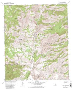
Fritz Canyon Topo Map Arizona
To zoom in, hover over the map of Fritz Canyon
USGS Topo Quad 33109c2 - 1:24,000 scale
| Topo Map Name: | Fritz Canyon |
| USGS Topo Quad ID: | 33109c2 |
| Print Size: | ca. 21 1/4" wide x 27" high |
| Southeast Coordinates: | 33.25° N latitude / 109.125° W longitude |
| Map Center Coordinates: | 33.3125° N latitude / 109.1875° W longitude |
| U.S. State: | AZ |
| Filename: | o33109c2.jpg |
| Download Map JPG Image: | Fritz Canyon topo map 1:24,000 scale |
| Map Type: | Topographic |
| Topo Series: | 7.5´ |
| Map Scale: | 1:24,000 |
| Source of Map Images: | United States Geological Survey (USGS) |
| Alternate Map Versions: |
Fritz Canyon AZ 1967, updated 1971 Download PDF Buy paper map Fritz Canyon AZ 1967, updated 1982 Download PDF Buy paper map Fritz Canyon AZ 1967, updated 1982 Download PDF Buy paper map Fritz Canyon AZ 1997, updated 2000 Download PDF Buy paper map Fritz Canyon AZ 2011 Download PDF Buy paper map Fritz Canyon AZ 2014 Download PDF Buy paper map |
| FStopo: | US Forest Service topo Fritz Canyon is available: Download FStopo PDF Download FStopo TIF |
1:24,000 Topo Quads surrounding Fritz Canyon
> Back to 33109a1 at 1:100,000 scale
> Back to 33108a1 at 1:250,000 scale
> Back to U.S. Topo Maps home
Fritz Canyon topo map: Gazetteer
Fritz Canyon: Gaps
Sunflower Saddle elevation 1704m 5590′Fritz Canyon: Reservoirs
Big Saddle Tank elevation 1475m 4839′Black Jack Tank elevation 1454m 4770′
Buckhorn Canyon Tank elevation 1371m 4498′
Buckhorn Tank elevation 1643m 5390′
Clear Creek Ridge Tank elevation 1582m 5190′
Dry Lake Tank elevation 1743m 5718′
Garage Tank elevation 1365m 4478′
Hobo Number Four Tanks elevation 1735m 5692′
Hobo Number Two Tank elevation 1873m 6145′
Horse Canyon Ridge Tank elevation 1713m 5620′
Jeep Tank elevation 1437m 4714′
Joe Fritz Pasture Tank elevation 1417m 4648′
Joe Fritz Tank elevation 1350m 4429′
Jump Up Tank elevation 1607m 5272′
Lower Tank elevation 1703m 5587′
Manning Tank elevation 1506m 4940′
Maple Number One Tank elevation 1801m 5908′
No Tank elevation 1462m 4796′
Number One Tank elevation 1425m 4675′
Piñon Mountain Tank elevation 1799m 5902′
Roan Cow Tank elevation 1774m 5820′
Sen Canyon Tank elevation 1878m 6161′
Suicide Tank elevation 1754m 5754′
Sunflower Saddle Tank elevation 1699m 5574′
Upper Salt Ground Tank elevation 1605m 5265′
White Basin Tank elevation 1510m 4954′
White Bluff Tank elevation 1585m 5200′
White Saddle Tank elevation 1471m 4826′
Wild Bunch Tank elevation 1438m 4717′
Winter Camp Tank elevation 1816m 5958′
Yellowstone Tank elevation 1396m 4580′
Fritz Canyon: Springs
Alder Spring elevation 1570m 5150′Big Horn Spring elevation 1352m 4435′
Black Coffee Spring elevation 1860m 6102′
Burns Spring elevation 1635m 5364′
Cienega Spring elevation 1547m 5075′
Cow Spring elevation 1582m 5190′
Divide Spring elevation 1654m 5426′
Dry Prong Seep elevation 1616m 5301′
Fish Spring elevation 1784m 5853′
Fritz Spring elevation 1383m 4537′
Head of Wild Bunch Spring elevation 1798m 5898′
Hobo Spring elevation 1528m 5013′
Holding Cienega Spring elevation 1325m 4347′
Horse Canyon Ridge Spring elevation 1772m 5813′
Lemonade Spring elevation 1705m 5593′
Maple Spring elevation 1510m 4954′
Mud Spring elevation 1544m 5065′
Onery Spring elevation 1316m 4317′
Pocket Spring elevation 1667m 5469′
Pungent Spring elevation 1527m 5009′
Rattlesnake Spring elevation 1486m 4875′
Rock Tank Spring elevation 1641m 5383′
Sour Spring elevation 1399m 4589′
Suicide Spring elevation 1558m 5111′
Sweet Spring elevation 1351m 4432′
Tea Bag Spirngs Number One elevation 1814m 5951′
Tea Bag Springs Number Three elevation 1742m 5715′
Tea Bag Springs Number Two elevation 1773m 5816′
The Spring elevation 1278m 4192′
Upper Cienega Spring elevation 1691m 5547′
Upper Mud Spring elevation 1649m 5410′
Upper Spring elevation 1689m 5541′
Wild Bear Spring elevation 1630m 5347′
Wild Bunch Spring elevation 1589m 5213′
Fritz Canyon: Streams
Alder Creek elevation 1326m 4350′Bear Creek elevation 1329m 4360′
Cienega Creek elevation 1240m 4068′
Clear Creek elevation 1270m 4166′
Juan Miller Creek elevation 1657m 5436′
Little Blue Creek elevation 1370m 4494′
Pigeon Creek elevation 1248m 4094′
Fritz Canyon: Summits
Pat Mesa elevation 1458m 4783′Pat Mountain elevation 1987m 6519′
Fritz Canyon: Valleys
Dry Prong Canyon elevation 1526m 5006′Fritz Canyon elevation 1287m 4222′
Harry Canyon elevation 1564m 5131′
Harry Canyon elevation 1404m 4606′
Horse Canyon elevation 1349m 4425′
Maple Canyon elevation 1365m 4478′
Mud Springs Canyon elevation 1254m 4114′
Open Canyon elevation 1584m 5196′
Porky Canyon elevation 1539m 5049′
Roan Cow Canyon elevation 1609m 5278′
Rock Tank Canyon elevation 1680m 5511′
Spring Canyon elevation 1523m 4996′
Suicide Canyon elevation 1584m 5196′
Wild Bunch Canyon elevation 1289m 4229′
Fritz Canyon digital topo map on disk
Buy this Fritz Canyon topo map showing relief, roads, GPS coordinates and other geographical features, as a high-resolution digital map file on DVD:


