Robinson Mesa Topo Map Arizona
To zoom in, hover over the map of Robinson Mesa
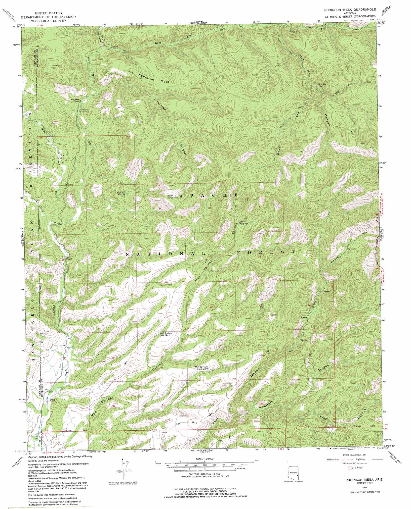
USGS Topo Quad 33109d4 - 1:24,000 scale
| Topo Map Name: | Robinson Mesa |
| USGS Topo Quad ID: | 33109d4 |
| Print Size: | ca. 21 1/4" wide x 27" high |
| Southeast Coordinates: | 33.375° N latitude / 109.375° W longitude |
| Map Center Coordinates: | 33.4375° N latitude / 109.4375° W longitude |
| U.S. State: | AZ |
| Filename: | o33109d4.jpg |
| Download Map JPG Image: | Robinson Mesa topo map 1:24,000 scale |
| Map Type: | Topographic |
| Topo Series: | 7.5´ |
| Map Scale: | 1:24,000 |
| Source of Map Images: | United States Geological Survey (USGS) |
| Alternate Map Versions: |
Robinson Mesa AZ 1967, updated 1970 Download PDF Buy paper map Robinson Mesa AZ 1967, updated 1982 Download PDF Buy paper map Robinson Mesa AZ 1967, updated 1991 Download PDF Buy paper map Robinson Mesa AZ 1997, updated 2000 Download PDF Buy paper map Robinson Mesa AZ 2011 Download PDF Buy paper map Robinson Mesa AZ 2014 Download PDF Buy paper map |
| FStopo: | US Forest Service topo Robinson Mesa is available: Download FStopo PDF Download FStopo TIF |
1:24,000 Topo Quads surrounding Robinson Mesa
Odart Mountain |
Maverick |
Hoodoo Knob |
Hannagan Meadow |
Beaverhead |
Maverick Sw |
Freezeout Mountain |
Baldy Bill Point |
Strayhorse |
Bear Mountain |
Sawbuck Mountain |
Willow Mountain |
Robinson Mesa |
Rose Peak |
Dutch Blue Creek |
Point Of Pines East |
Willow Mountain Se |
Bee Canyon |
Pipestem Mountain |
Fritz Canyon |
Park Creek Cabins |
Elevator Mountain |
Coronado Mountain |
Mitchell Peak |
Dix Creek |
> Back to 33109a1 at 1:100,000 scale
> Back to 33108a1 at 1:250,000 scale
> Back to U.S. Topo Maps home
Robinson Mesa topo map: Gazetteer
Robinson Mesa: Gaps
Sheep Saddle elevation 2234m 7329′Robinson Mesa: Ranges
Blue Range elevation 2434m 7985′Robinson Mesa: Reservoirs
Big Pasture Tank elevation 1571m 5154′Black Mountain Tank elevation 1811m 5941′
Blackwater Pit Tank elevation 1708m 5603′
Caborne Tank elevation 1903m 6243′
Circle Canyon Stock Tank elevation 2022m 6633′
Coyote Tank elevation 1912m 6272′
East Eagle Tank elevation 1751m 5744′
Glover Tank elevation 2014m 6607′
Goodwin Tank elevation 1702m 5583′
Hot Air Tank elevation 1946m 6384′
Mud Springs Canyon Tank elevation 1649m 5410′
Mud Springs Tank Number One elevation 1755m 5757′
Mud Springs Tank Number Two elevation 1717m 5633′
P Tank elevation 1669m 5475′
Road Tank elevation 1536m 5039′
Robinson Mesa Tank elevation 1878m 6161′
Sandy Tank elevation 1656m 5433′
Trail Tank elevation 1621m 5318′
West Fork Tank elevation 2033m 6669′
Robinson Mesa: Ridges
Glover Ridge elevation 2099m 6886′Robinson Mesa: Springs
Bear Cub Spring elevation 1966m 6450′Bear Spring elevation 1851m 6072′
Bear Spring Number One elevation 1897m 6223′
Juniper Spring elevation 1721m 5646′
Mud Springs elevation 1947m 6387′
Robinson Spring elevation 1707m 5600′
Tercer Springs Number Three elevation 2098m 6883′
Tercer Springs Number Two elevation 2135m 7004′
Robinson Mesa: Streams
Crabtree Creek elevation 1898m 6227′Dry Prong Creek elevation 1697m 5567′
East Eagle Creek elevation 1697m 5567′
Middle Prong Creek elevation 1591m 5219′
Wet Prong Creek elevation 1594m 5229′
Robinson Mesa: Summits
Robinson Mesa elevation 1898m 6227′Robinson Mesa: Trails
Adbar Trail Fourteen elevation 2184m 7165′Bear Canyon Trail elevation 1757m 5764′
East Eagle Trail Thirty-Three elevation 1852m 6076′
Hot Air Trail Fifteen elevation 1940m 6364′
Mud Springs Trail Forty-nine elevation 1788m 5866′
Robinson Mesa Twenty-seven Trail elevation 2168m 7112′
Robinson Mesa: Valleys
Hogtrail Canyon elevation 1698m 5570′Hot Air Canyon elevation 1816m 5958′
Pine Canyon elevation 1745m 5725′
Robinson Canyon elevation 1667m 5469′
West Fork Hot Air Canyon elevation 1926m 6318′
Robinson Mesa digital topo map on disk
Buy this Robinson Mesa topo map showing relief, roads, GPS coordinates and other geographical features, as a high-resolution digital map file on DVD: