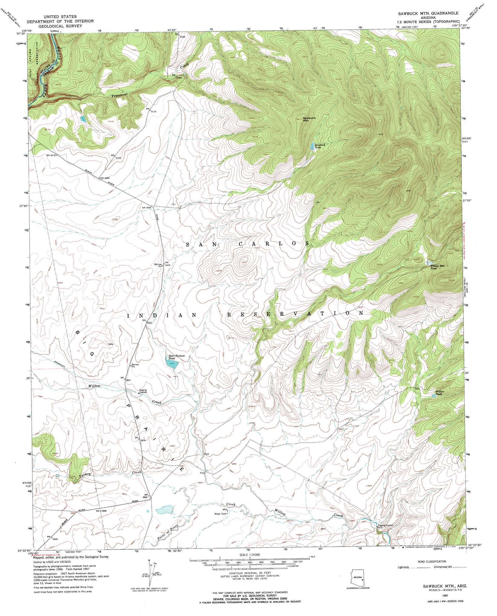
Sawbuck Mountain Topo Map Arizona
To zoom in, hover over the map of Sawbuck Mountain
USGS Topo Quad 33109d6 - 1:24,000 scale
| Topo Map Name: | Sawbuck Mountain |
| USGS Topo Quad ID: | 33109d6 |
| Print Size: | ca. 21 1/4" wide x 27" high |
| Southeast Coordinates: | 33.375° N latitude / 109.625° W longitude |
| Map Center Coordinates: | 33.4375° N latitude / 109.6875° W longitude |
| U.S. State: | AZ |
| Filename: | o33109d6.jpg |
| Download Map JPG Image: | Sawbuck Mountain topo map 1:24,000 scale |
| Map Type: | Topographic |
| Topo Series: | 7.5´ |
| Map Scale: | 1:24,000 |
| Source of Map Images: | United States Geological Survey (USGS) |
| Alternate Map Versions: |
Sawbuck Mtn. AZ 1967, updated 1970 Download PDF Buy paper map Sawbuck Mountain AZ 2011 Download PDF Buy paper map Sawbuck Mountain AZ 2014 Download PDF Buy paper map |
1:24,000 Topo Quads surrounding Sawbuck Mountain
Bonito Prairie |
Corn Creek |
Odart Mountain |
Maverick |
Hoodoo Knob |
Elwood Canyon |
West Poker Mountain |
Maverick Sw |
Freezeout Mountain |
Baldy Bill Point |
Natanes Mountains Nw |
Natanes Mountains Ne |
Sawbuck Mountain |
Willow Mountain |
Robinson Mesa |
Tule Tubs |
Point Of Pines West |
Point Of Pines East |
Willow Mountain Se |
Bee Canyon |
Gila Peak |
Bonita Tank |
Park Creek Cabins |
Elevator Mountain |
Coronado Mountain |
> Back to 33109a1 at 1:100,000 scale
> Back to 33108a1 at 1:250,000 scale
> Back to U.S. Topo Maps home
Sawbuck Mountain topo map: Gazetteer
Sawbuck Mountain: Dams
Freezeout Dam elevation 1870m 6135′Pump Station Dam elevation 1784m 5853′
Sawbuck Mountain: Flats
Big Prairie elevation 1825m 5987′Sawbuck Mountain: Reservoirs
Sawbuck Tank elevation 0m 0′Steer Pasture Tank elevation 1820m 5971′
Willow Mountain Tank elevation 1973m 6473′
Willow Tank elevation 1843m 6046′
Sawbuck Mountain: Streams
Freezeout Creek elevation 1756m 5761′Point of Pines Creek elevation 1778m 5833′
Turkey Creek elevation 1784m 5853′
Sawbuck Mountain: Summits
Sawbuck Mountain elevation 0m 0′Sawbuck Mountain digital topo map on disk
Buy this Sawbuck Mountain topo map showing relief, roads, GPS coordinates and other geographical features, as a high-resolution digital map file on DVD: