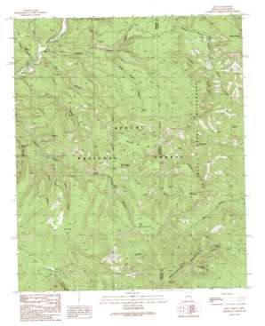
Blue Topo Map Arizona
To zoom in, hover over the map of Blue
USGS Topo Quad 33109e1 - 1:24,000 scale
| Topo Map Name: | Blue |
| USGS Topo Quad ID: | 33109e1 |
| Print Size: | ca. 21 1/4" wide x 27" high |
| Southeast Coordinates: | 33.5° N latitude / 109° W longitude |
| Map Center Coordinates: | 33.5625° N latitude / 109.0625° W longitude |
| U.S. States: | AZ, NM |
| Filename: | o33109e1.jpg |
| Download Map JPG Image: | Blue topo map 1:24,000 scale |
| Map Type: | Topographic |
| Topo Series: | 7.5´ |
| Map Scale: | 1:24,000 |
| Source of Map Images: | United States Geological Survey (USGS) |
| Alternate Map Versions: |
Blue AZ 1991, updated 1991 Download PDF Buy paper map Blue AZ 1997, updated 2000 Download PDF Buy paper map Blue AZ 2005, updated 2006 Download PDF Buy paper map Blue AZ 2011 Download PDF Buy paper map Blue AZ 2014 Download PDF Buy paper map |
| FStopo: | US Forest Service topo Blue is available: Download FStopo PDF Download FStopo TIF |
1:24,000 Topo Quads surrounding Blue
> Back to 33109e1 at 1:100,000 scale
> Back to 33108a1 at 1:250,000 scale
> Back to U.S. Topo Maps home
Blue topo map: Gazetteer
Blue: Cliffs
Tige Rim elevation 2285m 7496′Blue: Flats
Bonanza Bill Flat elevation 2294m 7526′Campbell Flat elevation 2318m 7604′
Cow Flat elevation 2321m 7614′
Blue: Forests
Apache National Forest elevation 2235m 7332′Blue: Lakes
Campbell Flat Lake elevation 2307m 7568′W S Lake elevation 2549m 8362′
Blue: Populated Places
Blue elevation 1755m 5757′Blue Vista elevation 1982m 6502′
Blue: Post Offices
Blue Post Office elevation 1754m 5754′Blue: Reservoirs
Dry Lakes elevation 2086m 6843′Stateline Tank elevation 2194m 7198′
Blue: Ridges
Fire Ridge elevation 2289m 7509′Blue: Springs
Bear Valley Cabin Spring elevation 2094m 6870′Bear Valley Spring elevation 2093m 6866′
Cashier Spring elevation 2160m 7086′
Cow Flat Spring elevation 2296m 7532′
Devil Spring elevation 2341m 7680′
Dutch Oven Spring elevation 1999m 6558′
Franz Spring elevation 2259m 7411′
Gray Bull Spring elevation 2133m 6998′
Grey Bull Spring elevation 2114m 6935′
Hinkle Spring elevation 2259m 7411′
Lower Steeple Spring elevation 1840m 6036′
Maple Spring elevation 2021m 6630′
Maverick Spring elevation 1971m 6466′
Tige Spring elevation 2291m 7516′
Twin Springs elevation 1769m 5803′
Upper Steeple Spring elevation 1863m 6112′
Whiterock Spring elevation 2211m 7253′
Whiterocks Spring elevation 2299m 7542′
Blue: Streams
Bush Creek elevation 1744m 5721′Blue: Summits
Bonanza Bill Point elevation 2435m 7988′Brushy Mountain elevation 2437m 7995′
Devils Monument elevation 2370m 7775′
Saddle Mountain elevation 2527m 8290′
W S Mountain elevation 2563m 8408′
Whiterocks Mountain elevation 2673m 8769′
Blue: Trails
Sycamore Trail elevation 2318m 7604′Blue: Valleys
Bear Valley elevation 2091m 6860′Cow Canyon elevation 1737m 5698′
Hinkle Spring Canyon elevation 1906m 6253′
Indian Canyon elevation 1904m 6246′
Muddy Canyon elevation 1978m 6489′
S Canyon elevation 1784m 5853′
Steeple Canyon elevation 1753m 5751′
Steeple Canyon elevation 1749m 5738′
Twin Springs Canyon elevation 1738m 5702′
Whoa Canyon elevation 1977m 6486′
Blue digital topo map on disk
Buy this Blue topo map showing relief, roads, GPS coordinates and other geographical features, as a high-resolution digital map file on DVD:


