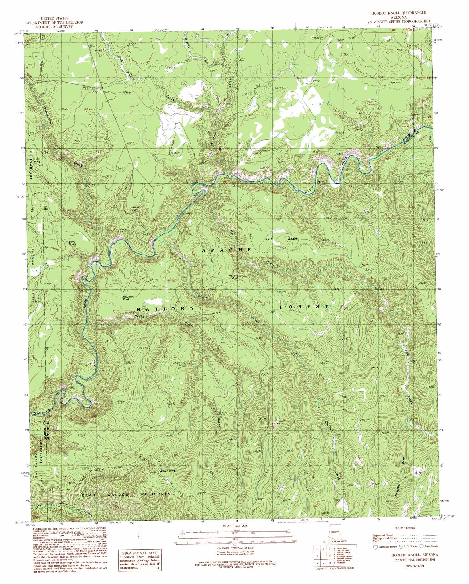
Hoodoo Knob Topo Map Arizona
To zoom in, hover over the map of Hoodoo Knob
USGS Topo Quad 33109f4 - 1:24,000 scale
| Topo Map Name: | Hoodoo Knob |
| USGS Topo Quad ID: | 33109f4 |
| Print Size: | ca. 21 1/4" wide x 27" high |
| Southeast Coordinates: | 33.625° N latitude / 109.375° W longitude |
| Map Center Coordinates: | 33.6875° N latitude / 109.4375° W longitude |
| U.S. State: | AZ |
| Filename: | o33109f4.jpg |
| Download Map JPG Image: | Hoodoo Knob topo map 1:24,000 scale |
| Map Type: | Topographic |
| Topo Series: | 7.5´ |
| Map Scale: | 1:24,000 |
| Source of Map Images: | United States Geological Survey (USGS) |
| Alternate Map Versions: |
Hoodoo Knoll AZ 1991, updated 1991 Download PDF Buy paper map Hoodoo Knoll AZ 1997, updated 2000 Download PDF Buy paper map Hoodoo Knoll AZ 2011 Download PDF Buy paper map Hoodoo Knoll AZ 2014 Download PDF Buy paper map |
| FStopo: | US Forest Service topo Hoodoo Knoll is available: Download FStopo PDF Download FStopo TIF |
1:24,000 Topo Quads surrounding Hoodoo Knob
Hawley Lake East |
Mount Baldy |
Big Lake North |
Rudd Knoll |
Nutrioso |
Marshall Butte |
Bonito Rock |
Big Lake South |
Buffalo Crossing |
Alpine |
Odart Mountain |
Maverick |
Hoodoo Knob |
Hannagan Meadow |
Beaverhead |
Maverick Sw |
Freezeout Mountain |
Baldy Bill Point |
Strayhorse |
Bear Mountain |
Sawbuck Mountain |
Willow Mountain |
Robinson Mesa |
Rose Peak |
Dutch Blue Creek |
> Back to 33109e1 at 1:100,000 scale
> Back to 33108a1 at 1:250,000 scale
> Back to U.S. Topo Maps home
Hoodoo Knob topo map: Gazetteer
Hoodoo Knob: Basins
Coyote Sink elevation 2314m 7591′Fish Sink elevation 2395m 7857′
Hoodoo Knob: Benches
Fish Bench elevation 2362m 7749′Hoodoo Knob: Flats
Paradise Park elevation 2199m 7214′Hoodoo Knob: Lakes
Elk Lake elevation 2427m 7962′McKibbins Pond elevation 2207m 7240′
Hoodoo Knob: Reservoirs
Bear Tank elevation 2298m 7539′Black Tank elevation 2287m 7503′
Burn Tank elevation 2365m 7759′
Carlock Tank elevation 2343m 7687′
Elk Tank elevation 2398m 7867′
Fishbench Tank elevation 2335m 7660′
Gobbler Tank elevation 2272m 7454′
Gravel Pit Tank elevation 2274m 7460′
Holiday Tank elevation 2363m 7752′
Juno Tank elevation 2528m 8293′
Knoll Tank elevation 2380m 7808′
L Fifty-six Tank elevation 2381m 7811′
Loop Tank elevation 2472m 8110′
Maverick Tank elevation 2360m 7742′
Pond Tank elevation 2354m 7723′
PS Tank elevation 2364m 7755′
Reservation Tank elevation 2283m 7490′
Salt Lick Tank elevation 2320m 7611′
Section Three Tank elevation 2539m 8330′
Slaughter Tank elevation 2318m 7604′
Snake Tank elevation 2354m 7723′
Tadpole Tank elevation 2383m 7818′
Turkey Enclosure Tank elevation 2347m 7700′
Turkey Tank elevation 2343m 7687′
Turkey Track Tank elevation 2404m 7887′
Wildcat Tank elevation 2318m 7604′
Wren Tank elevation 2528m 8293′
Hoodoo Knob: Springs
Bill Earl Spring elevation 2355m 7726′Burk Seep elevation 2366m 7762′
Long Canyon Spring elevation 2463m 8080′
Mushroom Seep elevation 2369m 7772′
Perry Spring elevation 2273m 7457′
Side Canyon Spring elevation 2392m 7847′
Hoodoo Knob: Streams
Boggy Creek elevation 2303m 7555′Centerfire Creek elevation 2102m 6896′
Conklin Creek elevation 2077m 6814′
Fish Creek elevation 2106m 6909′
Reservation Creek elevation 2060m 6758′
Snake Creek elevation 2035m 6676′
Wildcat Creek elevation 2206m 7237′
Hoodoo Knob: Summits
Gobbler Point elevation 2673m 8769′Hoodoo Knoll elevation 2403m 7883′
Wildcat Point elevation 2310m 7578′
Hoodoo Knob: Valleys
Slaughter Draw elevation 2445m 8021′Hoodoo Knob digital topo map on disk
Buy this Hoodoo Knob topo map showing relief, roads, GPS coordinates and other geographical features, as a high-resolution digital map file on DVD: