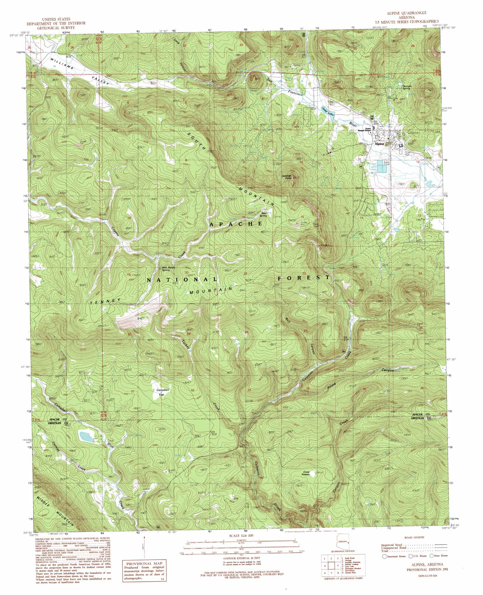
Alpine Topo Map Arizona
To zoom in, hover over the map of Alpine
USGS Topo Quad 33109g2 - 1:24,000 scale
| Topo Map Name: | Alpine |
| USGS Topo Quad ID: | 33109g2 |
| Print Size: | ca. 21 1/4" wide x 27" high |
| Southeast Coordinates: | 33.75° N latitude / 109.125° W longitude |
| Map Center Coordinates: | 33.8125° N latitude / 109.1875° W longitude |
| U.S. State: | AZ |
| Filename: | o33109g2.jpg |
| Download Map JPG Image: | Alpine topo map 1:24,000 scale |
| Map Type: | Topographic |
| Topo Series: | 7.5´ |
| Map Scale: | 1:24,000 |
| Source of Map Images: | United States Geological Survey (USGS) |
| Alternate Map Versions: |
Alpine AZ 1991, updated 1991 Download PDF Buy paper map Alpine AZ 1997, updated 2000 Download PDF Buy paper map Alpine AZ 2011 Download PDF Buy paper map Alpine AZ 2014 Download PDF Buy paper map |
| FStopo: | US Forest Service topo Alpine is available: Download FStopo PDF Download FStopo TIF |
1:24,000 Topo Quads surrounding Alpine
Greer |
Eagar |
Nelson Reservoir |
Loco Knoll |
Jones Canyon |
Big Lake North |
Rudd Knoll |
Nutrioso |
Escudilla Mountain |
Underwood Lake |
Big Lake South |
Buffalo Crossing |
Alpine |
Luna Lake |
Luna |
Hoodoo Knob |
Hannagan Meadow |
Beaverhead |
Maness Peak |
Bull Basin |
Baldy Bill Point |
Strayhorse |
Bear Mountain |
Blue |
Saliz Pass |
> Back to 33109e1 at 1:100,000 scale
> Back to 33108a1 at 1:250,000 scale
> Back to U.S. Topo Maps home
Alpine topo map: Gazetteer
Alpine: Basins
DT Sink elevation 2643m 8671′Porcelain Sink elevation 2753m 9032′
Spit Sink elevation 2827m 9274′
Alpine: Flats
Campbell Flat elevation 2482m 8143′Alpine: Lakes
Corner Lake elevation 2747m 9012′Elk Wallow Lake elevation 2637m 8651′
Halfmoon Lake elevation 2810m 9219′
Alpine: Populated Places
Alpine elevation 2442m 8011′Alpine: Reservoirs
Bear Spring Tank elevation 2855m 9366′Bennys Tank elevation 2729m 8953′
Bobs Tank elevation 2472m 8110′
Bull Tank elevation 2815m 9235′
C-7 Tank elevation 2682m 8799′
Campbell Flat Tank elevation 2483m 8146′
Canyon Creek Tank elevation 2528m 8293′
Canyon Creek Tank elevation 2584m 8477′
Carlton Tank elevation 2574m 8444′
Catch All Tank elevation 2630m 8628′
Center Tank elevation 2737m 8979′
Central Tank elevation 2806m 9206′
Chaparral Tank elevation 2531m 8303′
Cienega Tank elevation 2428m 7965′
Clyde Tank elevation 2475m 8120′
Clyde Tank elevation 2452m 8044′
Corner Tank elevation 2689m 8822′
Corral Tank elevation 2622m 8602′
Coyote Tank elevation 2676m 8779′
Coyote Tank elevation 2697m 8848′
Crow Poison Tank elevation 2487m 8159′
Donata Tank elevation 2531m 8303′
Draw Tank elevation 2736m 8976′
Dugout Tank elevation 2769m 9084′
E Tank elevation 2844m 9330′
Franks Tank elevation 2687m 8815′
George Tank elevation 2601m 8533′
Georges Lake Tank elevation 2493m 8179′
Georges Tank elevation 2500m 8202′
Half Section Tank elevation 2497m 8192′
Jacks Tank elevation 2517m 8257′
JC Tank elevation 2496m 8188′
Judd Lake elevation 2440m 8005′
Lee Tank elevation 2694m 8838′
Log Culvert Tank elevation 2413m 7916′
Long Canyon Fork Tank elevation 2658m 8720′
Lookout Pasture Tank elevation 2648m 8687′
Lower Nobel Draw Tank elevation 2632m 8635′
Lower Timber Bench Tank elevation 2673m 8769′
Middle Fork Tank elevation 2528m 8293′
Norm Tank elevation 2633m 8638′
Old Rim Tank elevation 2413m 7916′
Quail Tank elevation 2485m 8152′
Raw Tank elevation 2518m 8261′
Reynolds Tank elevation 2560m 8398′
Rincon Tank elevation 2595m 8513′
Road Steak Tank elevation 2702m 8864′
Roadside Tank elevation 2646m 8681′
SE Tank elevation 2621m 8599′
Section Eight Tank elevation 2799m 9183′
Section Twenty-four Tank elevation 2446m 8024′
Seldom Seen Tank elevation 2504m 8215′
Shallow Tank elevation 2634m 8641′
Skousen Tank elevation 2681m 8795′
Smileys Tank elevation 2618m 8589′
South Tank elevation 2697m 8848′
Spout Spring Tank elevation 2862m 9389′
Spring Stock Tank elevation 2636m 8648′
Sulzberger Tank elevation 2627m 8618′
Timber Bench Tank elevation 2735m 8973′
Turkey Creek Draw Tank elevation 2543m 8343′
Twins Tanks elevation 2402m 7880′
Two X Tank elevation 2446m 8024′
Upper Canyon Creek Tank elevation 2623m 8605′
Upper Canyon Creek Tank elevation 2669m 8756′
Williams Tank elevation 2647m 8684′
X E Tank elevation 2713m 8900′
XE Tank elevation 2668m 8753′
XV Tank elevation 2678m 8786′
Alpine: Springs
Bear Spring elevation 2853m 9360′Bear Spring elevation 2850m 9350′
Cienega Creek Spring elevation 2404m 7887′
Georges Spring elevation 2516m 8254′
Georges Spring elevation 2515m 8251′
Isabell Spring elevation 2428m 7965′
Joes Spring elevation 2479m 8133′
Milk Ranch Spring elevation 2673m 8769′
Snow Shoe Spring elevation 2816m 9238′
Spout Spring elevation 2845m 9333′
Upper Beaver Spring elevation 2505m 8218′
Willimans Valley Spring elevation 2513m 8244′
Alpine: Streams
Canyon Creek elevation 2292m 7519′Cienega Creek elevation 2382m 7814′
Turkey Creek elevation 2405m 7890′
Turkey Creek elevation 2452m 8044′
Alpine: Summits
Gobbler Point elevation 2820m 9251′South Mountain elevation 2899m 9511′
Tenney Mountain elevation 2705m 8874′
Tenny Mountain elevation 2758m 9048′
Alpine: Valleys
Bull Canyon elevation 2515m 8251′Long Canyon elevation 2609m 8559′
Prime Canyon elevation 2475m 8120′
Alpine digital topo map on disk
Buy this Alpine topo map showing relief, roads, GPS coordinates and other geographical features, as a high-resolution digital map file on DVD: