Corn Creek Plateau Topo Map Arizona
To zoom in, hover over the map of Corn Creek Plateau
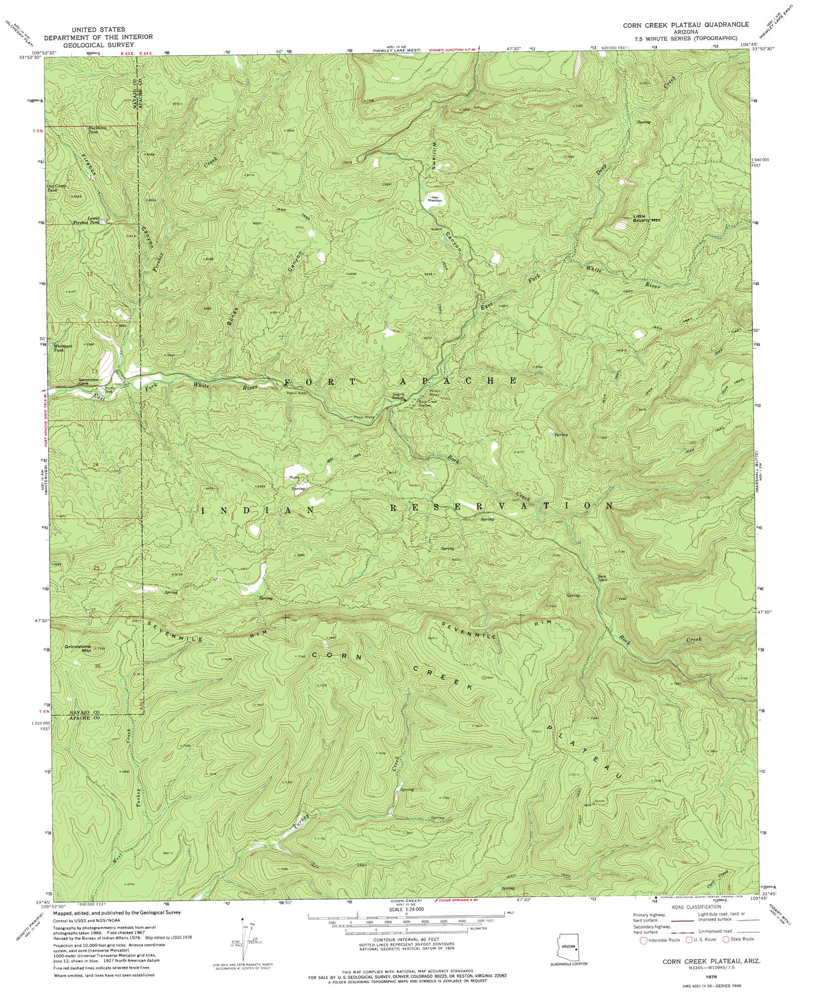
USGS Topo Quad 33109g7 - 1:24,000 scale
| Topo Map Name: | Corn Creek Plateau |
| USGS Topo Quad ID: | 33109g7 |
| Print Size: | ca. 21 1/4" wide x 27" high |
| Southeast Coordinates: | 33.75° N latitude / 109.75° W longitude |
| Map Center Coordinates: | 33.8125° N latitude / 109.8125° W longitude |
| U.S. State: | AZ |
| Filename: | o33109g7.jpg |
| Download Map JPG Image: | Corn Creek Plateau topo map 1:24,000 scale |
| Map Type: | Topographic |
| Topo Series: | 7.5´ |
| Map Scale: | 1:24,000 |
| Source of Map Images: | United States Geological Survey (USGS) |
| Alternate Map Versions: |
Corn Creek Plateau AZ 1967, updated 1970 Download PDF Buy paper map Corn Creek Plateau AZ 1978, updated 1978 Download PDF Buy paper map Corn Creek Plateau AZ 2011 Download PDF Buy paper map Corn Creek Plateau AZ 2014 Download PDF Buy paper map |
1:24,000 Topo Quads surrounding Corn Creek Plateau
Faught Ridge |
Indian Pine |
Mcnary |
Horseshoe Cienega |
Greens Peak |
Round Top Mountain |
Alchesay Flat |
Hawley Lake West |
Hawley Lake East |
Mount Baldy |
Canyon Day |
Whiteriver |
Corn Creek Plateau |
Marshall Butte |
Bonito Rock |
Velasquez Butte |
Bonito Prairie |
Corn Creek |
Odart Mountain |
Maverick |
Georges Butte |
Elwood Canyon |
West Poker Mountain |
Maverick Sw |
Freezeout Mountain |
> Back to 33109e1 at 1:100,000 scale
> Back to 33108a1 at 1:250,000 scale
> Back to U.S. Topo Maps home
Corn Creek Plateau topo map: Gazetteer
Corn Creek Plateau: Flats
Hay Meadow elevation 2057m 6748′Corn Creek Plateau: Parks
Rock Creek Picnic Area elevation 1840m 6036′Corn Creek Plateau: Plains
Corn Creek Plateau elevation 2337m 7667′Corn Creek Plateau: Reservoirs
Buckhorn Tank elevation 1902m 6240′Lower Firebox Tank elevation 1832m 6010′
Corn Creek Plateau: Streams
Deep Creek elevation 2009m 6591′Firebox Creek elevation 1708m 5603′
Rock Creek elevation 1822m 5977′
Corn Creek Plateau: Summits
Grindstone Mountain elevation 2237m 7339′Little Brushy Mountain elevation 2297m 7536′
Corn Creek Plateau: Valleys
Bones Canyon elevation 1744m 5721′Firebox Canyon elevation 1716m 5629′
Williams Canyon elevation 1925m 6315′
Corn Creek Plateau digital topo map on disk
Buy this Corn Creek Plateau topo map showing relief, roads, GPS coordinates and other geographical features, as a high-resolution digital map file on DVD: