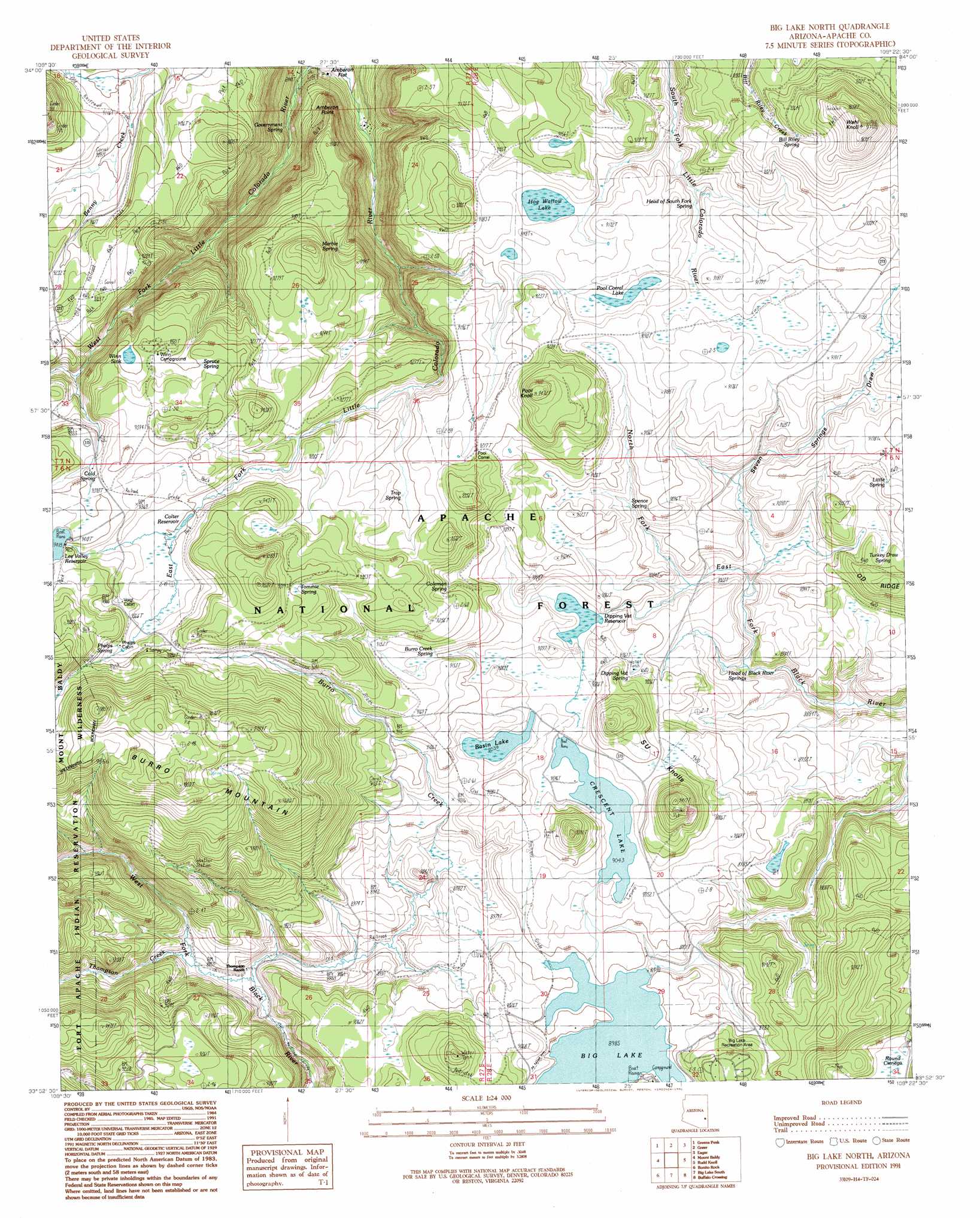
Big Lake North Topo Map Arizona
To zoom in, hover over the map of Big Lake North
USGS Topo Quad 33109h4 - 1:24,000 scale
| Topo Map Name: | Big Lake North |
| USGS Topo Quad ID: | 33109h4 |
| Print Size: | ca. 21 1/4" wide x 27" high |
| Southeast Coordinates: | 33.875° N latitude / 109.375° W longitude |
| Map Center Coordinates: | 33.9375° N latitude / 109.4375° W longitude |
| U.S. State: | AZ |
| Filename: | o33109h4.jpg |
| Download Map JPG Image: | Big Lake North topo map 1:24,000 scale |
| Map Type: | Topographic |
| Topo Series: | 7.5´ |
| Map Scale: | 1:24,000 |
| Source of Map Images: | United States Geological Survey (USGS) |
| Alternate Map Versions: |
Big Lake North AZ 1991, updated 1991 Download PDF Buy paper map Big Lake North AZ 1991, updated 1991 Download PDF Buy paper map Big Lake North AZ 1997, updated 2000 Download PDF Buy paper map Big Lake North AZ 2011 Download PDF Buy paper map Big Lake North AZ 2014 Download PDF Buy paper map |
| FStopo: | US Forest Service topo Big Lake North is available: Download FStopo PDF Download FStopo TIF |
1:24,000 Topo Quads surrounding Big Lake North
Boundary Butte |
Whiting Knoll |
Springerville Nw |
Springerville |
Coyote Hills |
Horseshoe Cienega |
Greens Peak |
Greer |
Eagar |
Nelson Reservoir |
Hawley Lake East |
Mount Baldy |
Big Lake North |
Rudd Knoll |
Nutrioso |
Marshall Butte |
Bonito Rock |
Big Lake South |
Buffalo Crossing |
Alpine |
Odart Mountain |
Maverick |
Hoodoo Knob |
Hannagan Meadow |
Beaverhead |
> Back to 33109e1 at 1:100,000 scale
> Back to 33108a1 at 1:250,000 scale
> Back to U.S. Topo Maps home
Big Lake North topo map: Gazetteer
Big Lake North: Basins
Rudd Knoll Pit elevation 2830m 9284′Trap Pit elevation 2800m 9186′
Big Lake North: Cliffs
Amberon Point elevation 2729m 8953′Big Lake North: Dams
Big Lake Dam elevation 2740m 8989′Burro Mountain Weir elevation 2784m 9133′
Crescent Lake Dam elevation 2759m 9051′
Hog Wallow Dam elevation 2788m 9146′
Lee Valley Dam elevation 2870m 9416′
Pool Corral Dam elevation 2792m 9160′
River Number One Dam elevation 2873m 9425′
Big Lake North: Flats
Round Cienega elevation 2704m 8871′Big Lake North: Lakes
Basin Lake elevation 2756m 9041′Big Lake elevation 2732m 8963′
Colter Reservoir elevation 2835m 9301′
Crescent Lake elevation 2758m 9048′
Dipping Vat Reservoir elevation 2749m 9019′
Hog Wallow Lake elevation 2779m 9117′
Pool Corral Lake elevation 2784m 9133′
Big Lake North: Reservoirs
71 Tank elevation 2792m 9160′72 Tank elevation 2767m 9078′
75 Tank elevation 2726m 8943′
Ant Tank elevation 2805m 9202′
BC Tank elevation 2817m 9242′
BC Tank Number 1 elevation 2798m 9179′
Big Lake elevation 2740m 8989′
Bill Riley Tank elevation 2832m 9291′
Blade Tank elevation 2797m 9176′
Boundary Tank elevation 2725m 8940′
Bull Pasture Tank elevation 2779m 9117′
Butch Tank elevation 2785m 9137′
Cherokee Tank elevation 2744m 9002′
Corner Tank elevation 2749m 9019′
Crossbar Tank elevation 2740m 8989′
Deep Pit Tank elevation 2836m 9304′
Dot Tank elevation 2790m 9153′
Draw Tank elevation 2785m 9137′
Drumstick Tank elevation 2790m 9153′
Egg Tank elevation 2715m 8907′
Elk Pit Tank elevation 2818m 9245′
Fence Tank elevation 2800m 9186′
Fir Pit Tank elevation 2812m 9225′
Half Tank elevation 2844m 9330′
Horse Corral Tank elevation 2788m 9146′
Lake Tank elevation 2785m 9137′
Line Tank elevation 2726m 8943′
Lower Tank elevation 2818m 9245′
Mandan Tank elevation 2737m 8979′
Mel Tank elevation 2789m 9150′
Mine Tank elevation 2772m 9094′
Mud Tank elevation 2780m 9120′
North Hog Wallow Tank elevation 2779m 9117′
Pasture Tank elevation 2779m 9117′
Pool Corral Lake Tank elevation 2785m 9137′
Pool Knoll Tank elevation 2775m 9104′
Pothole Tank elevation 2763m 9064′
Riley Canyon Tank elevation 2812m 9225′
Riley Tank elevation 2754m 9035′
Road Tank elevation 2803m 9196′
Road Tank elevation 2803m 9196′
Round Tank elevation 2730m 8956′
Rudd Knoll Tank Number 5 elevation 2829m 9281′
Ruth Tank elevation 2698m 8851′
Section 25 Tank elevation 2756m 9041′
Seventy-Four Tank elevation 2724m 8937′
Seventy-Three Tank elevation 2769m 9084′
South Fork Tank elevation 2770m 9087′
South Fork Tank elevation 2766m 9074′
South Hog Wallow Tank elevation 2779m 9117′
Stock Tank Number 1 elevation 2792m 9160′
Track Tank elevation 2768m 9081′
Turkey Tank elevation 2844m 9330′
Udall Pit Tank Number 8 elevation 2697m 8848′
Upper Tank elevation 2819m 9248′
Voigt Pit Tank Number 1 elevation 2806m 9206′
Voigt Pit Tank Number 2 elevation 2794m 9166′
Voigt Pit Tank Number Six elevation 2838m 9311′
Big Lake North: Springs
75 Spring elevation 2745m 9005′Alleged Spring elevation 2768m 9081′
Bill Riley Spring elevation 2847m 9340′
Black River Spring elevation 2751m 9025′
Boardshack Spring elevation 2781m 9124′
Buckshot Spring elevation 2942m 9652′
Buckshot Spring elevation 2942m 9652′
Burro Creek Spring elevation 2785m 9137′
Burro Creek Spring elevation 2716m 8910′
Burro Creek Spring Number 1 elevation 2854m 9363′
Cienega Spring elevation 2753m 9032′
Clear Cut Spring elevation 2838m 9311′
Cold Spring elevation 2854m 9363′
Coleman Spring elevation 2801m 9189′
Convicted Spring elevation 2776m 9107′
Crescent Lake Spring elevation 2766m 9074′
Day Spring elevation 2818m 9245′
Definite Spring elevation 2774m 9101′
Developed Spring elevation 2810m 9219′
Dipping Vat Spring elevation 2752m 9028′
Double Spring elevation 2797m 9176′
Dump Spring elevation 2726m 8943′
Government Spring elevation 2610m 8562′
Head of Black River Springs elevation 2708m 8884′
Head of South Fork Spring elevation 2770m 9087′
House Corral Spring elevation 2784m 9133′
Little Spring elevation 2784m 9133′
Marble Spring elevation 2793m 9163′
Merlyn Spring elevation 2765m 9071′
Need Spring elevation 2831m 9288′
Phelps Spring elevation 2872m 9422′
Point Spring elevation 2826m 9271′
Pool Corral Spring elevation 2812m 9225′
Reservoir Spring elevation 2793m 9163′
Rock Spring elevation 2712m 8897′
Round Cienega Spring elevation 2708m 8884′
Seven Springs elevation 2786m 9140′
Spence Spring elevation 2752m 9028′
Spruce Spring elevation 2835m 9301′
Spruce Spring elevation 2784m 9133′
Spruce Spring elevation 2937m 9635′
SU Knolls Spring elevation 2764m 9068′
SU Spring elevation 2717m 8914′
Sugar Spring elevation 2860m 9383′
Tommie Spring elevation 2865m 9399′
Trap Spring elevation 2804m 9199′
Trap Spring Number 2 elevation 2805m 9202′
Trap Tank Spring elevation 2784m 9133′
Turkey Draw Spring elevation 2754m 9035′
Udall 12 Spring elevation 2726m 8943′
Voigt Spring elevation 2854m 9363′
Big Lake North: Streams
Burro Creek elevation 2690m 8825′North Fork Black River elevation 2670m 8759′
Thompson Creek elevation 2703m 8868′
Big Lake North: Summits
Burro Mountain elevation 2952m 9685′Pool Knoll elevation 2883m 9458′
S U Knolls elevation 2868m 9409′
Slide Hill elevation 2780m 9120′
Wahl Knoll elevation 2967m 9734′
Big Lake North: Swamps
Wing Marsh elevation 2790m 9153′Winn Sink elevation 2834m 9297′
Big Lake North: Trails
East Fork Baldy Trail Ninetyfive elevation 2819m 9248′Big Lake North: Valleys
Seven Springs Draw elevation 2722m 8930′Big Lake North: Wells
409 Road Well elevation 2805m 9202′Fence Spring elevation 2835m 9301′
Seven Springs Well elevation 2832m 9291′
Big Lake North digital topo map on disk
Buy this Big Lake North topo map showing relief, roads, GPS coordinates and other geographical features, as a high-resolution digital map file on DVD: