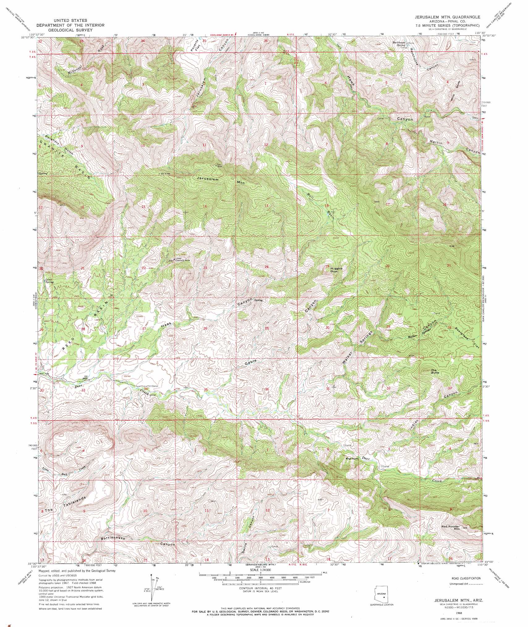
Jerusalem Mountain Topo Map Arizona
To zoom in, hover over the map of Jerusalem Mountain
USGS Topo Quad 33110a5 - 1:24,000 scale
| Topo Map Name: | Jerusalem Mountain |
| USGS Topo Quad ID: | 33110a5 |
| Print Size: | ca. 21 1/4" wide x 27" high |
| Southeast Coordinates: | 33° N latitude / 110.5° W longitude |
| Map Center Coordinates: | 33.0625° N latitude / 110.5625° W longitude |
| U.S. State: | AZ |
| Filename: | o33110a5.jpg |
| Download Map JPG Image: | Jerusalem Mountain topo map 1:24,000 scale |
| Map Type: | Topographic |
| Topo Series: | 7.5´ |
| Map Scale: | 1:24,000 |
| Source of Map Images: | United States Geological Survey (USGS) |
| Alternate Map Versions: |
Jerusalem Mtn. AZ 1968, updated 1971 Download PDF Buy paper map Jerusalem Mountain AZ 2011 Download PDF Buy paper map Jerusalem Mountain AZ 2014 Download PDF Buy paper map |
1:24,000 Topo Quads surrounding Jerusalem Mountain
Pinal Peak |
Cutter |
Bucket Mountain |
San Carlos |
Mount Triplet |
El Capitan Mountain |
Mescal Warm Spring |
Coolidge Dam |
San Carlos Reservoir |
Dewey Flat |
Hayden |
Christmas |
Jerusalem Mountain |
Rawhide Mountain |
Mount Turnbull |
Winkelman |
Dudleyville |
Brandenburg Mountain |
Booger Canyon |
Cobre Grande Mountain |
Putnam Wash |
Lookout Mountain |
Holy Joe Peak |
Oak Grove Canyon |
Klondike |
> Back to 33110a1 at 1:100,000 scale
> Back to 33110a1 at 1:250,000 scale
> Back to U.S. Topo Maps home
Jerusalem Mountain topo map: Gazetteer
Jerusalem Mountain: Basins
Bull Basin elevation 1266m 4153′Reed Basin elevation 842m 2762′
Jerusalem Mountain: Cliffs
White Bluffs elevation 1000m 3280′Jerusalem Mountain: Mines
Lower Coalfield Mine elevation 1001m 3284′Jerusalem Mountain: Springs
Lime Spring elevation 936m 3070′Rockhouse Spring elevation 869m 2851′
Walker Springs elevation 1119m 3671′
Jerusalem Mountain: Summits
Huggins Peak elevation 1319m 4327′Jerusalem Mountain elevation 1612m 5288′
Red Rooster Mountain elevation 1484m 4868′
The Butte elevation 1305m 4281′
Jerusalem Mountain: Valleys
Gable Canyon elevation 860m 2821′Haas Canyon elevation 817m 2680′
Indian Canyon elevation 970m 3182′
Martin Canyon elevation 817m 2680′
Walker Springs Canyon elevation 907m 2975′
Jerusalem Mountain digital topo map on disk
Buy this Jerusalem Mountain topo map showing relief, roads, GPS coordinates and other geographical features, as a high-resolution digital map file on DVD: