Bylas Topo Map Arizona
To zoom in, hover over the map of Bylas
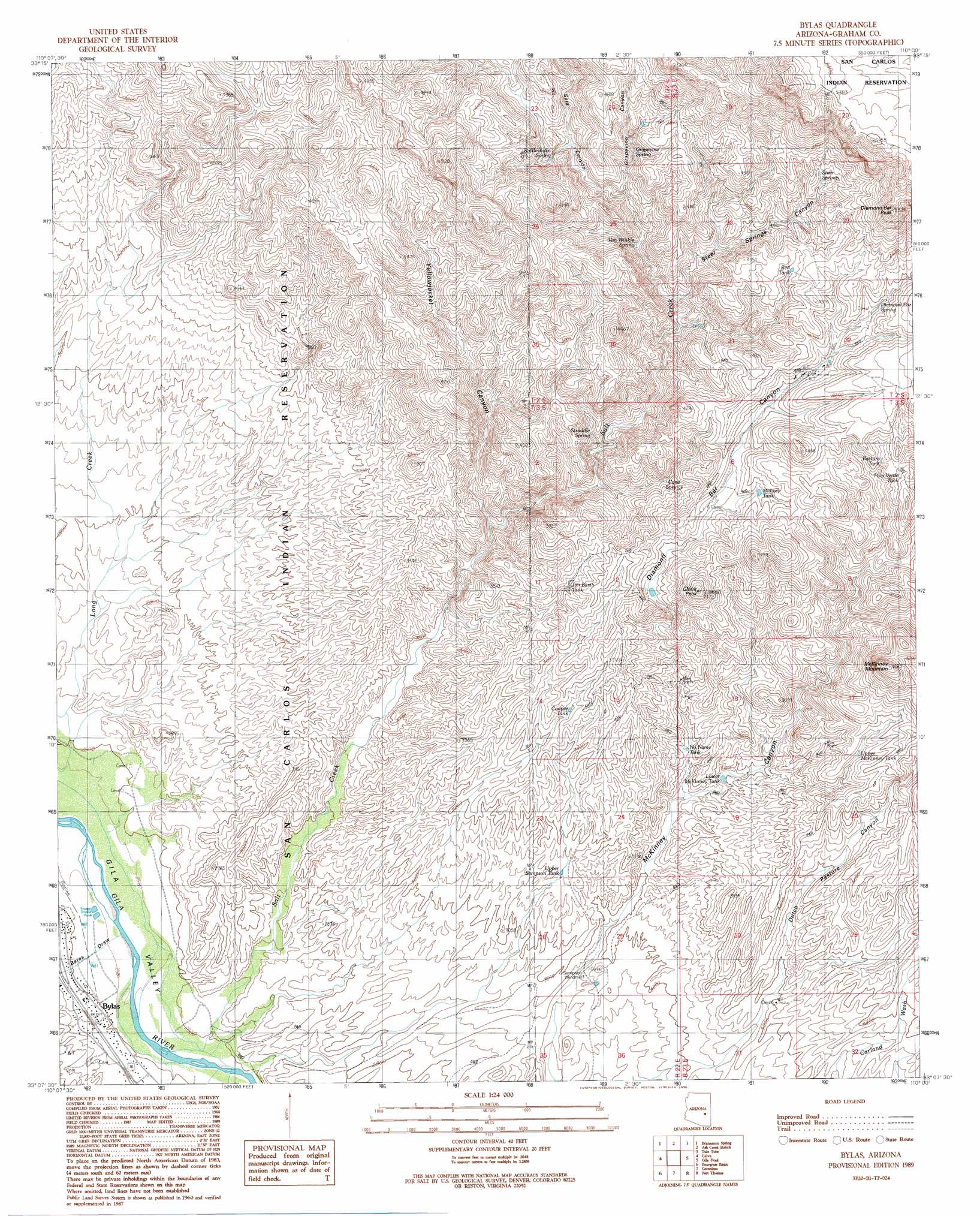
USGS Topo Quad 33110b1 - 1:24,000 scale
| Topo Map Name: | Bylas |
| USGS Topo Quad ID: | 33110b1 |
| Print Size: | ca. 21 1/4" wide x 27" high |
| Southeast Coordinates: | 33.125° N latitude / 110° W longitude |
| Map Center Coordinates: | 33.1875° N latitude / 110.0625° W longitude |
| U.S. State: | AZ |
| Filename: | o33110b1.jpg |
| Download Map JPG Image: | Bylas topo map 1:24,000 scale |
| Map Type: | Topographic |
| Topo Series: | 7.5´ |
| Map Scale: | 1:24,000 |
| Source of Map Images: | United States Geological Survey (USGS) |
| Alternate Map Versions: |
Bylas AZ 1989, updated 1990 Download PDF Buy paper map Bylas AZ 2011 Download PDF Buy paper map Bylas AZ 2014 Download PDF Buy paper map |
1:24,000 Topo Quads surrounding Bylas
Sontag Mesa |
Bronco Gulch |
Ash Creek Ne |
Natanes Mountains Nw |
Natanes Mountains Ne |
Mount Triplet |
Branaman Spring |
Ash Creek Ranch |
Tule Tubs |
Point Of Pines West |
Dewey Flat |
Calva |
Bylas |
Gila Peak |
Bonita Tank |
Mount Turnbull |
Beargrass Basin |
Geronimo |
Fort Thomas |
Markham Creek |
Cobre Grande Mountain |
Jackson Mountain |
Telegraph Wash |
Eden |
Pima |
> Back to 33110a1 at 1:100,000 scale
> Back to 33110a1 at 1:250,000 scale
> Back to U.S. Topo Maps home
Bylas topo map: Gazetteer
Bylas: Populated Places
Bylas elevation 796m 2611′Bylas: Reservoirs
Cooper Tank elevation 1053m 3454′Jim Barth Tank elevation 1090m 3576′
Longstreet Tank elevation 1261m 4137′
Lower McKinney Tank elevation 963m 3159′
Midway Tank elevation 1208m 3963′
No Name Tank elevation 964m 3162′
Palo Verde Tank elevation 1241m 4071′
Pasture Tank elevation 1229m 4032′
Red Tank elevation 1281m 4202′
Upper McKinney Tank elevation 1109m 3638′
Upper Sampson Tank elevation 950m 3116′
Bylas: Springs
Cane Springs elevation 1121m 3677′Diamond Bar Spring elevation 1278m 4192′
Grapevine Spring elevation 1240m 4068′
Rattlesnake Spring elevation 1212m 3976′
Steer Springs elevation 1291m 4235′
Straddle Spring elevation 1060m 3477′
Van Winkle Spring elevation 1143m 3750′
Bylas: Streams
Salt Creek elevation 0m 0′Bylas: Summits
China Peak elevation 1323m 4340′Diamond Bar Peak elevation 1612m 5288′
McKinney Mountain elevation 1396m 4580′
Bylas: Valleys
Diamond Bar Canyon elevation 945m 3100′Grapevine Canyon elevation 1160m 3805′
Sam Canyon elevation 0m 0′
Steer Springs Canyon elevation 1119m 3671′
Yellowjacket Canyon elevation 974m 3195′
Bylas digital topo map on disk
Buy this Bylas topo map showing relief, roads, GPS coordinates and other geographical features, as a high-resolution digital map file on DVD: