Mount Triplet Topo Map Arizona
To zoom in, hover over the map of Mount Triplet
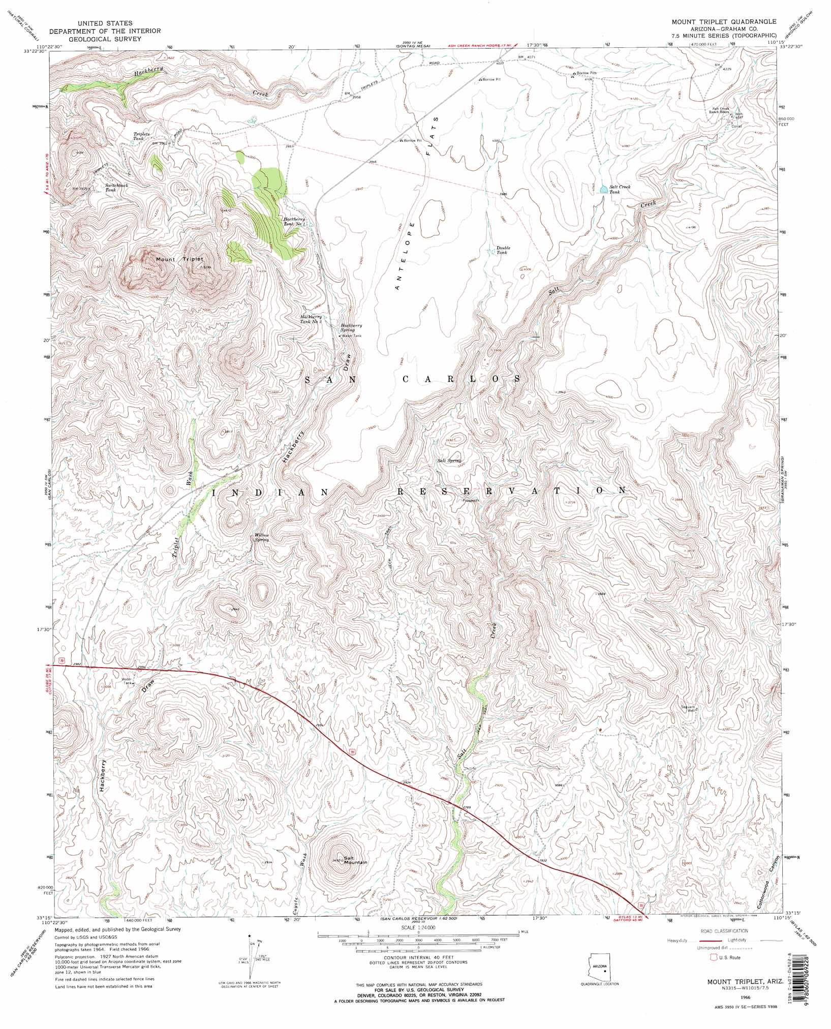
USGS Topo Quad 33110c3 - 1:24,000 scale
| Topo Map Name: | Mount Triplet |
| USGS Topo Quad ID: | 33110c3 |
| Print Size: | ca. 21 1/4" wide x 27" high |
| Southeast Coordinates: | 33.25° N latitude / 110.25° W longitude |
| Map Center Coordinates: | 33.3125° N latitude / 110.3125° W longitude |
| U.S. State: | AZ |
| Filename: | o33110c3.jpg |
| Download Map JPG Image: | Mount Triplet topo map 1:24,000 scale |
| Map Type: | Topographic |
| Topo Series: | 7.5´ |
| Map Scale: | 1:24,000 |
| Source of Map Images: | United States Geological Survey (USGS) |
| Alternate Map Versions: |
Mount Triplet AZ 1966, updated 1968 Download PDF Buy paper map Mount Triplet AZ 1966, updated 1968 Download PDF Buy paper map Mount Triplet AZ 2011 Download PDF Buy paper map Mount Triplet AZ 2014 Download PDF Buy paper map |
1:24,000 Topo Quads surrounding Mount Triplet
Sevenmile Mountains |
Cassadore Spring |
Sontag Creek |
Chiricahua Butte |
Georges Butte |
Dourine Canyon |
Natural Corral |
Sontag Mesa |
Bronco Gulch |
Ash Creek Ne |
Bucket Mountain |
San Carlos |
Mount Triplet |
Branaman Spring |
Ash Creek Ranch |
Coolidge Dam |
San Carlos Reservoir |
Dewey Flat |
Calva |
Bylas |
Jerusalem Mountain |
Rawhide Mountain |
Mount Turnbull |
Beargrass Basin |
Geronimo |
> Back to 33110a1 at 1:100,000 scale
> Back to 33110a1 at 1:250,000 scale
> Back to U.S. Topo Maps home
Mount Triplet topo map: Gazetteer
Mount Triplet: Reservoirs
Double Tank elevation 1207m 3959′Hackberry Tank Number One elevation 1181m 3874′
Hackberry Tank Number Two elevation 1142m 3746′
Salt Creek Tank elevation 0m 0′
Switchback Tank elevation 1177m 3861′
Triplets Tank elevation 1171m 3841′
Mount Triplet: Springs
Hackberry Spring elevation 1121m 3677′Salt Spring elevation 0m 0′
Willow Spring elevation 992m 3254′
Mount Triplet: Streams
Triplet Wash elevation 915m 3001′Mount Triplet: Summits
Mount Triplet elevation 1614m 5295′Salt Mountain elevation 0m 0′
Mount Triplet: Wells
Saguaro Well elevation 0m 0′Mount Triplet digital topo map on disk
Buy this Mount Triplet topo map showing relief, roads, GPS coordinates and other geographical features, as a high-resolution digital map file on DVD: